Lower Austria is one of the nine states of Austria, located in the northeastern corner of the country. Since 1986, the capital of Lower Austria has been Sankt Pölten, replacing Vienna which became a separate state in 1921. With a land area of 19,186 km2 (7,408 sq mi) and a population of 1.685 million people, Lower Austria is the second most populous federal state. Other large cities are Amstetten, Klosterneuburg, Krems an der Donau, Stockerau and Wiener Neustadt.

Articles related to Austria include:

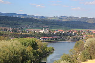
Krems an der Donau is a town of 23,992 inhabitants in Austria, in the federal state of Lower Austria. It is the fifth-largest city of Lower Austria and is approximately 70 kilometres west of Vienna. Krems is a city with its own statute, and therefore it is both a municipality and a district.

Melk Abbey is a Benedictine abbey above the town of Melk, Lower Austria, Austria, on a rocky outcrop overlooking the Danube river, adjoining the Wachau valley. The abbey contains the tomb of Saint Coloman of Stockerau and the remains of several members of the House of Babenberg, Austria's first ruling dynasty.

The University for Continuing Education Krems is an Austrian university specializing in further education for working professionals. It is located in Krems an der Donau, Lower Austria.
Bezirk Melk is a district of the state of Lower Austria in Austria.
Dunkelsteinerwald is a market municipality with 2,289 inhabitants in the district Melk in Lower Austria, Austria.
Mauer is a village in the municipality of Dunkelsteinerwald, in the Mostviertel in Lower Austria, Austria.

Göttweig Abbey is a Benedictine monastery near Krems in Lower Austria. It was founded in 1083 by Altmann, Bishop of Passau.

Maria Taferl is an Austrian market municipality of 872 people in the District of Melk and the most important pilgrimage site in all of Lower Austria. After Mariazell, Maria Taferl is the most important pilgrimage destination in all of Austria.
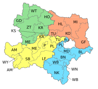
Mostviertel is the southwestern quarter of the four quarters of Lower Austria. It is bordered on the north by the Danube and to the south and west by the state borders of Styria and Upper Austria respectively. The Wienerwald forms the natural border to the east and gives the quarter its second name, "The Quarter over the Wienerwald".
Bezirk Krems-Land is a district of the state of Lower Austria in Austria. It comprises the areas to the West and North of the city Krems an der Donau, which itself is a statutory city.
The Waldviertel is the northwestern region of the northeast Austrian state of Lower Austria. It is bounded to the south by the Danube, to the southwest by Upper Austria, to the northwest and the north by the Czech Republic and to the east by the Manhartsberg, which is the survey point dividing Waldviertel from Weinviertel. Geologically it is a part of the Bohemian Massif. In the south are the Wachau and Kamptal wine regions.

Mautern an der Donau is a town in the district of Krems-Land in the Austrian state of Lower Austria.

The Wachau is an Austrian valley with a picturesque landscape formed by the Danube river. It is one of the most prominent tourist destinations of Lower Austria, located midway between the towns of Melk and Krems that also attracts "connoisseurs and epicureans" for its high-quality wines. It is 36 kilometres (22 mi) in length and was already settled in prehistoric times. A well-known place and tourist attraction is Dürnstein, where King Richard the Lionheart of England was held captive by Duke Leopold V of Austria and Styria. The architectural elegance of its ancient monasteries, castles and ruins combined with the urban architecture of its towns and villages, and the cultivation of vines as an important agricultural produce are the dominant features of the valley.

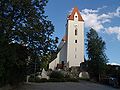
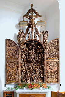
Gansbach is a small town and centre of the municipality of Dunkelsteinerwald in Melk District, Lower Austria in northeastern Austria. It lies several kilometres inland from the Danube. To the west and north of the settlement is the Wachau valley. The parish church probably originates from the 14th century. The side altar piece of the famous painter Kremser Schmidt and the high altarpiece, which was painted by one of his students are of note.
Krapfenberg is a settlement in the municipality of Dunkelsteinerwald in Melk District, Lower Austria in northeastern Austria.
Lottersberg is a settlement in the municipality of Dunkelsteinerwald in Melk District, Lower Austria in northeastern Austria.
Nölling is a settlement in the municipality of Dunkelsteinerwald in Melk District, Lower Austria in northeastern Austria.
Via donau is a subsidiary of the Austrian Ministry for Transport, Innovation and Technology (bmvit) tasked with the preservation and development of the Danube waterway. It was established in 2005.