
Austria-Hungary, also referred to as the Austro-Hungarian Empire, the Dual Monarchy or the Habsburg Monarchy, was a multi-national constitutional monarchy in Central Europe between 1867 and 1918. A military and diplomatic alliance, it consisted of two sovereign states with a single monarch who was titled both Emperor of Austria and King of Hungary. Austria-Hungary constituted the last phase in the constitutional evolution of the Habsburg monarchy: it was formed with the Austro-Hungarian Compromise of 1867 in the aftermath of the Austro-Prussian War, following wars of independence by Hungary in opposition to Habsburg rule. It was dissolved shortly after Hungary terminated the union with Austria in 1918.

Croatia, officially the Republic of Croatia, is a country in Central and Southeast Europe, on the coast of the Adriatic Sea. It borders Slovenia to the northwest, Hungary to the northeast, Serbia to the east, Bosnia and Herzegovina and Montenegro to the southeast, and shares a maritime border with Italy to the west. Its capital and largest city, Zagreb, forms one of the country's primary subdivisions, with twenty counties. Other major urban centers include Split, Rijeka and Osijek. The country spans 56,594 square kilometres, and has a population of nearly 3.9 million.
At the time of the Roman Empire, the area of modern Croatia comprised two Roman provinces, Pannonia and Dalmatia. After the collapse of the Western Roman Empire in the 5th century, the area was subjugated by the Ostrogoths for 50 years, before being incorporated into the Byzantine Empire.

The Croats are a South Slavic ethnic group native to Croatia, Bosnia and Herzegovina and other neighboring countries in Central and Southeastern Europe who share a common Croatian ancestry, culture, history and language. They also form a sizeable minority in a number of neighboring countries, namely Slovenia, Austria, the Czech Republic, Germany, Hungary, Italy, Montenegro, Romania, Serbia and Slovakia.

Burgenland is the easternmost and least populous state of Austria. It consists of two statutory cities and seven rural districts, with a total of 171 municipalities. It is 166 km (103 mi) long from north to south but much narrower from west to east. The region is part of the Centrope Project. The name of Burgenland was invented/coined in 1922, after its territories became part of Austria. The population of Burgenland as of 1 January 2024 is 301,951. Burgenland's capital is Eisenstadt.

Charles I was Emperor of Austria, King of Hungary, and the ruler of the other states of the Habsburg monarchy from November 1916 until the monarchy was abolished in November 1918. He was the last of the monarchs belonging to the House of Habsburg-Lorraine to rule over Austria-Hungary. The son of Archduke Otto of Austria and Princess Maria Josepha of Saxony, Charles became heir presumptive of Emperor Franz Joseph when his uncle Archduke Franz Ferdinand of Austria was assassinated in 1914. In 1911, he married Princess Zita of Bourbon-Parma.

Vojvodina, officially the Autonomous Province of Vojvodina, is an autonomous province that occupies the northernmost part of Serbia, located in Central Europe. It lies within the Pannonian Basin, bordered to the south by the national capital Belgrade and the Sava and Danube Rivers. The administrative centre, Novi Sad, is the second-largest city in Serbia.

Rijeka, also known as Fiume, is the principal seaport and the third-largest city in Croatia. It is located in Primorje-Gorski Kotar County on Kvarner Bay, an inlet of the Adriatic Sea and in 2021 had a population of 108,622 inhabitants. Historically, because of its strategic position and its excellent deep-water port, the city was fiercely contested, especially between the Holy Roman Empire, Italy and Croatia, changing rulers and demographics many times over centuries. According to the 2011 census data, the majority of its citizens are Croats, along with small numbers of Serbs, Bosniaks and Italians.

The State of Slovenes, Croats and Serbs was a political entity that was constituted in October 1918, at the end of World War I, by Slovenes, Croats and Serbs (Prečani) residing in what were the southernmost parts of the Austro-Hungarian Empire. Although internationally unrecognised, this was the first incarnation of a Yugoslav state founded on the Pan-Slavic ideology. Thirty-three days after it was proclaimed, the state joined the Kingdom of Serbia to form the Kingdom of Serbs, Croats and Slovenes.

The Kingdom of Croatia entered a personal union with the Kingdom of Hungary in 1102, after a period of rule of kings from the Trpimirović and Svetoslavić dynasties and a succession crisis following the death of king Demetrius Zvonimir. With the coronation of King Coloman of Hungary as "King of Croatia and Dalmatia" in 1102 in Biograd, the realm passed to the Árpád dynasty until 1301, when the (male) line of the dynasty died out. Then, kings from the Capetian House of Anjou, who were also cognatic descendants of the Árpád kings, ruled the kingdoms. Later centuries were characterized by conflicts with the Mongols, who sacked Zagreb in 1242, competition with Venice for control over Dalmatian coastal cities, and internal warfare among Croatian nobility. Various individuals emerged during the period, such as Paul I Šubić of Bribir, who was representing the most powerful Croatian dynasty at the time, the Šubić noble family. These powerful individuals were on occasion able to de facto secure great deal of independence for their fiefdoms. The Ottoman incursion into Europe in the 16th century significantly reduced Croatian territories and left the country weak and divided. After the death of Louis II in 1526 during the Battle of Mohács and a brief period of dynastic dispute, both crowns passed to the Austrian House of Habsburg, and the realms became part of the Habsburg monarchy.

The Kingdom of Hungary was a monarchy in Central Europe that existed for nearly a millennium, from 1000 to 1946. The Principality of Hungary emerged as a Christian kingdom upon the coronation of the first king Stephen I at Esztergom around the year 1000; his family led the monarchy for 300 years. By the 12th century, the kingdom became a European power.

Southeast Europe or Southeastern Europe is a geographical sub-region of Europe, consisting primarily of the region of the Balkans, as well as adjacent regions and archipelagos. There are overlapping and conflicting definitions of the region, due to political, economic, historical, cultural, and geographical considerations.

The Pannonian Basin or Carpathian Basin is a large sedimentary basin situated in southeast Central Europe. After the Treaty of Trianon following World War I, the geomorphological term Pannonian Plain became more widely used for roughly the same region, referring to the lowlands in the area occupied by the Pannonian Sea during the Pliocene Epoch. "Pannonian Plain" term being considered not only unhistorical but also topologically erroneous term.

Baranya or Baranja is a geographical and historical region between the Danube and the Drava rivers located in the Pannonian Plain. Its territory is divided between Hungary and Croatia. In Hungary, the region is included in Baranya county, while in Croatia, it is part of Osijek-Baranja county.
The Kingdom of Croatia, or Croatian Kingdom, was a medieval kingdom in Southern Europe comprising most of what is today Croatia, as well as most of the modern-day Bosnia and Herzegovina. The Croatian Kingdom was ruled for part of its existence by ethnic dynasties, and the Kingdom existed as a sovereign state for nearly two centuries. Its existence was characterized by various conflicts and periods of peace or alliance with the Bulgarians, Byzantines, Hungarians, and competition with Venice for control over the eastern Adriatic coast. The goal of promoting the Croatian language in the religious service was initially introduced by the 10th century bishop Gregory of Nin, which resulted in a conflict with the Pope, later to be put down by him. In the second half of the 11th century Croatia managed to secure most coastal cities of Dalmatia with the collapse of Byzantine control over them. During this time the kingdom reached its peak under the rule of kings Peter Krešimir IV (1058–1074) and Demetrius Zvonimir (1075–1089).

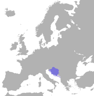
The Kingdom of Croatia-Slavonia was a nominally autonomous kingdom and constitutionally defined separate political nation within the Austro-Hungarian Empire. It was created in 1868 by merging the kingdoms of Croatia and Slavonia following the Croatian–Hungarian Settlement of 1868. It was associated with the Kingdom of Hungary within the dual Austro-Hungarian state, being within the Lands of the Crown of St. Stephen, also known as Transleithania. While Croatia had been granted a wide internal autonomy with "national features", in reality, Croatian control over key issues such as tax and military issues was minimal and hampered by Hungary. It was internally officially referred to as the Triune Kingdom of Croatia, Slavonia and Dalmatia, also simply known as the Triune Kingdom, and had claims on Dalmatia, which was administered separately by the Austrian Cisleithania. The city of Rijeka, following a disputed section in the 1868 Settlement known as the Rijeka Addendum, became a corpus separatum and was legally owned by Hungary, but administered by both Croatia and Hungary.

The Lands of the Crown of Saint Stephen, informally Transleithania, were the Hungarian territories of Austria-Hungary, throughout the latter's entire existence, and which disintegrated following its dissolution. The name referenced the historic coronation crown of Hungary, known as the Crown of Saint Stephen of Hungary, which had a symbolic importance to the Kingdom of Hungary.

The Kingdom of Croatia was part of the Lands of the Hungarian Crown, but was subject to direct Imperial Austrian rule for significant periods of time, including its final years. Its capital was Zagreb. It was also a part of the lands of the Habsburg monarchy from 1527, following the Election in Cetin, and the Austrian Empire from 1804 to 1867.

Bosnia and Herzegovina fell under Austro-Hungarian rule in 1878, when the Congress of Berlin approved the occupation of the Bosnia Vilayet, which officially remained part of the Ottoman Empire. Three decades later, in 1908, Austria-Hungary provoked the Bosnian Crisis by formally annexing the occupied zone, establishing the Condominium of Bosnia and Herzegovina under the joint control of Austria and Hungary.


