Related Research Articles

Hazelton is a village located at the junction of the Bulkley and Skeena Rivers in northern British Columbia, Canada. It was founded in 1866 and has a population of 305 (2011). The nearby larger community of New Hazelton is the northernmost point of the Yellowhead Highway, a major interprovincial highway which runs from Prince Rupert, British Columbia, to Portage la Prairie, Manitoba.

The Kitimat Ranges are one of the three main subdivisions of the Coast Mountains in British Columbia, Canada, the others being the Pacific Ranges to the south and the Boundary Ranges to the north.
Babine River Corridor Provincial Park is a provincial park in British Columbia, Canada, located to the north of Hazelton. The park was established by Order-in-Council in 1999 and is approximately 15,339 hectares in area.
Bulkley Junction Provincial Park is a provincial park in British Columbia, Canada, located on the west side of the Skeena River opposite Hazelton.
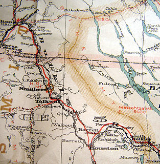
The Bulkley Valley is in the northwest Central Interior of British Columbia, Canada.
The Omineca Mountains, also known as "the Ominecas", are a group of remote mountain ranges in the Boreal Cordillera of north-central British Columbia, Canada. They are bounded by the Finlay River on the north, the Rocky Mountain Trench on the east, the Nation Lakes on the south, and the upper reaches of the Omineca River on the west. They form a section of the Continental Divide, that, in this region, separates water drainage between the Arctic and Pacific Oceans. The lower course of the Omineca River flows through the heart of the range. To the south of the Ominecas is the Nechako Plateau, to the west the Skeena Mountains and Hazelton Mountains, to the north the Spatsizi Plateau and the Stikine Ranges, while east across the Rocky Mountain Trench are the Muskwa Ranges.

The Hazelton Mountains are a grouping of mountain ranges on the inland lee of the Kitimat Ranges of the Coast Mountains in northwestern British Columbia, Canada, spanning the area of Hazelton south to the Nechako Reservoir. Defined by the British Columbia geographic names office, they span from the Nass River to the Nechako Plateau, and between the Coast Mountains and the Bulkley River, they are considered by geographers to be part of the Interior Mountains complex, though in local perspective they are considered to be part of the Coast Mountains. They are neighboured on the west by the Kitimat Ranges and on the east by the southernmost section of the Skeena Mountains; beyond the Nass River, which is their northern boundary, are the Boundary Ranges of the Coast Mountains. To their southeast is the Nechako Plateau, including the Quanchus Range on the near-island between Ootsa and Eutsuk Lakes of the Nechako Reservoir.
Gitsegukla is a Gitxsan community of about 500 at the confluence of the Kitseguecla and Skeena Rivers, approximately 40 km southwest of Hazelton, British Columbia, Canada. The community is on Gitsegukla Indian Reserve No. 1.

Kispiox is a Gitxsan village of approximately 550 in the Kispiox Valley, at the confluence of the Kispiox and Skeena Rivers in British Columbia. Located 13 km (8 mi) north of Hazelton, the community is situated within the Kispiox Indian Reserve and is managed by the Kispiox Band Council.
Simon Gunanoot was a prosperous Gitxsan man and a merchant in the Kispiox Valley region of Hazelton, British Columbia, Canada. He lived with his wife and children on a large ranch. A posse sought him after a murder but he escaped, retrieved his family and hid out. Eventually he surrendered and stood trial. He was found not guilty. The case garnered extensive media coverage and Gunanoot became a figure of legendary status.

Kitwanga or Gitwangak or Gitwangax is located where the Kitwanga River runs into the Skeena River in British Columbia. A long-standing village before contact, the village is within Gitwangak Indian Reserve No. 1.
The Nass Ranges are a mountain range north of the Skeena River, west of Hazelton, and northeast of Terrace, British Columbia, Canada. It is associated with the Hazelton Mountains, which in turn form part of the Interior Mountains.
Hagwilget Canyon is a canyon on the Bulkley River of northwestern British Columbia, Canada, located several kilometres upstream from that river's confluence with the Skeena River at Hazelton, at the Wet'suwet'en village of Hagwilget.

ʼKsan is a historical village and living museum of the Gitxsan Indigenous people in the Skeena Country of Northwestern British Columbia, Canada. ʼKsan is located near Hazelton at the confluence of the Skeena and Bulkley Rivers on Gitxsan territory.
Glen Vowell is an Indian reserve community of the Gitxsan people in the Hazelton area of the Skeena Country of northwestern British Columbia, Canada. It is located on the west side of the Skeena River between Hazelton and Kispiox. Its traditional name is Sik i dak, which has also been spelled Sikadoak and is reflected in the name of the reserve, Sik-e-dahk IR 2. Also nearby is another Indian reserve, Anlaw Indian Reserve No. 4. The band government of the reserve is the Glen Vowell Indian Band, which also goes by the name Sik-e-Dakh.

The Kitwanga River is a tributary of the Skeena River near Hazelton in northwestern British Columbia, Canada, joining that stream at the community of Kitwanga (Gitwangak), which means "people of the place of rabbits".
The Kispiox Range is a subrange of the Hazelton Mountains, located between the Kispiox and Kitwanga Rivers in northern British Columbia, Canada. The range is about 18 miles (29 km) long by 8 miles (13 km) wide.
Mount Thomlinson is a mountain in the Babine Range of the Skeena Mountains in northern British Columbia, Canada, located at the head of Thomlinson Creek, southeast of the junction of Babine River and Skeena River and north of Hazelton. It has a prominence of 1,661 m (5,449 ft), created by the Babine-Stuart Pass, thus making it one of Canada's many Ultra peaks. Thomlinson is one of the most isolated mountains of Canada.
Kispiox Mountain is the highest mountain in the Kispiox Range of the Hazelton Mountains in northern British Columbia, Canada, located northwest of the junction of Kispiox River and Skeena River. It has a prominence of 1,561 m (5,121 ft), created by the Kispiox-Nass Pass, thus making it one of Canada's many ultra-prominent peaks.
The Sustut River is a major tributary of the Skeena River in the north-central Interior of British Columbia, Canada. It forms the northwest boundary of the Hogem Ranges and flows southwest to meet the Skeena, north of Hazelton. Originally named the Bear Wallow River, its headwaters are at Sustut Lake, northwest of Germansen Landing.
References
- ↑ BC Names/GeoBC entry "Kispiox River"
- ↑ "Bulletin 48: Landforms of British Columbia. S. Holland, "Kispiox Range", pp. 58-59" (PDF). Archived from the original (PDF) on 2016-03-04. Retrieved 2014-04-30.
Coordinates: 55°20′33″N127°41′36″W / 55.34250°N 127.69333°W