Kiwira River

Last updated
Kiwira River
Bridge of God, Kiwira valley Tanzania2.jpg
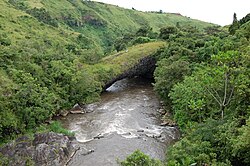
Daraja la Mungu, a natural bridge spanning Kiwira River west of Tukuyu
Lake Malawie Tanzania OSM.png
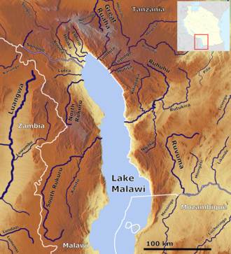
Kiwira river (top left center)
Native nameMto Kiwira (Swahili)
Location
Country Tanzania
Region Mbeya
District Kyela District
District Rungwe District
Physical characteristics
Source Mount Rungwe, Poroto Mountains
2nd sourceMarogala Stream
3rd sourceSinini Stream
4th sourceKipoke Stream
5th sourceKilasi Stream
Mouth Lake Malawi

Kiwira River is a river located in Rungwe District and Kyela District of Mbeya Region, Tanzania.

Contents

Course

It rises in the Poroto Mountains southeast of Mbeya and receives several streams originating on the slopes of Mount Rungwe, including the Marogala, Sinini, Kipoke, Kilasi and Mulagala. [1] Kijungu Falls is on the upper course of the river. It then flows southeast and empties into the northern end of Lake Malawi near the town of Kyela. [2] The lower course flows through the Kyela Plain, which sits northwest of Lake Malawi in the valley of the East African Rift. The Kyela Plain is cultivated intensively with rice and other crops. [3]

Daraja la Mungu

Daraja la Mungu (Swahili : "Bridge of God") is a natural bridge that spans the Kiwira River at 9°16′37″S33°33′07″E / 9.27703°S 33.55185°E / -9.27703; 33.55185 , reputedly formed less than a thousand years ago by a lava flow from Mount Rungwe. It can be viewed from a man-made bridge crossing the river 500 m upstream. [4]

Related Research Articles

<span class="mw-page-title-main">Geography of Tanzania</span>

Tanzania comprises many lakes, national parks, and Africa's highest point, Mount Kilimanjaro. Northeast Tanzania is mountainous, while the central area is part of a large plateau covered in grasslands. The country also contains the southern portion of Lake Victoria on its northern border with Uganda and Kenya.

<span class="mw-page-title-main">Mbeya</span> City in Mbeya Region, Tanzania

Mbeya is a city located in south west Tanzania, Africa, with an urban population of 649,000 in 2023. Mbeya is the capital of the surrounding rural Mbeya region.

<span class="mw-page-title-main">Mbeya Region</span> Region of Tanzania

Mbeya Region is one of Tanzania's 31 administrative regions. The region covers an area of 35,954 km2 (13,882 sq mi). The region is comparable in size to the combined land area of the nation state of Guinea Bissau. Mbeya Region is bordered to the east by Singida Region, Iringa Region and Njombe Region. The region is bordered to the south by Malawi and Lake Nyasa. To the north the region borders southern Tabora Region. Lastly, Mbeya is bordered to the west by Songwe Region. The regional capital is the city of Mbeya. According to the 2012 national census, the region had a population of 2,707,410.

The Kipengere Range, also known as the Livingstone Mountains, lies entirely in Njombe Region in southwest Tanzania at the northern end of Lake Nyasa. Near Lake Nyasa they are known as the Kinga Mountains. It is a plateau-like ridge of mountains running southeastwards from the basin of the Great Ruaha River in the north to that of the Ruhuhu River in the south, and forms part of the eastern escarpment of the East African Rift. The range is mostly clad in montane grasslands, renowned for their botanical diversity and displays of flowers, with montane evergreen forests mostly in stream valleys.

<span class="mw-page-title-main">Ileje District</span> District in Songwe Region, Tanzania

Ileje District is a district in Songwe Region, Tanzania. It is bordered to the north by Mbeya Urban and Rungwe districts, to the east by Kyela District, to the northwest by Mbozi District and to the south by Zambia and Malawi.

<span class="mw-page-title-main">Rungwe District</span> District in Tanzania

Rungwe is a District in Mbeya Region, Tanzania. It is bordered to the north by Mbeya Rural District, to the east by Busokelo District, to the southeast by Kyela District, to the southwest by Ileje District and to the west by Mbeya District.

<span class="mw-page-title-main">Kyela District</span> District of Mbeya Region, Tanzania

Kyela is one of the seven districts of Mbeya Region, Tanzania. It is bordered to the north by Rungwe District, to the northeast by Njombe Region, to the southeast by Lake Nyasa, to the south by Malawi and to the west by Ileje District.

<span class="mw-page-title-main">Mount Rungwe</span> Volcano in Mbeya Region of Tanzania

Mount Rungwe is a volcanic mountain in Mbeya Region, in Tanzania's Southern Highlands. At an altitude of 2,981 metres (9,780 ft), it is southern Tanzania's second-highest peak. Rungwe's volcano is currently inactive.

<span class="mw-page-title-main">Tukuyu</span> Town in Rugwe District, Mbeya Region, Tanzania

Tukuyu, known as Neu Langenburg during the German colonial rule, is a hillside town that lies about 36 miles (58 km) south of the city of Mbeya, at an elevation of around 5,000 ft (1,500 m) in the highland Rungwe District of southern Tanzania, East Africa. Tukuyu town has a moderate to cool temperature ranging from 10 °C in May and June to mid 20 °C in around November. The town and surrounding areas are green all year round due to the almost year-round convectional rains resulting from Lake Nyasa(Lake Malawi).Tukuyu town is divided into several wards include; Kawetere, Msasani, Bulyaga and Bagamoyo.

<span class="mw-page-title-main">Outline of Tanzania</span> Overview of and topical guide to Tanzania

The following outline is provided as an overview of and topical guide to Tanzania:

The Poroto Mountains are a mountain range in the Mbeya Region of Tanzania. They are located east of the city of Mbeya. The Poroto Mountains are a northwestward extension of the Kipengere Range, and part of the Southern Highlands. The Poroto mountains are volcanic in origin, part of the geological Rungwe Volcanic Province.

<span class="mw-page-title-main">Mbaka River</span>

Mbaka River is a river of Mbeya Region, Tanzania. It originates on the south slopes of Mount Rungwe and flows southeast into the north end of Lake Malawi at Mwaya.

Suma River is a river of Mbeya Region, Tanzania. It originates on the southern slopes of Mount Rungwe and is a tributary of the Mbaka River.

Mwatisi is a river of Tanzania. It flows through the Mbeya Region.

The Southern Highlands is a highland region in southwestern Tanzania, at the northern end of Lake Malawi. The highlands include portions of Mbeya, Njombe, Rukwa, Ruvuma, and Songwe regions, bordering Malawi, Mozambique, and Zambia. Mbeya is the largest city in the highlands.

Mbeya Range is a volcanic mountain range in Mbeya Region, in southwestern Tanzania, East Africa. It forms an arc just north of the town of Mbeya and includes Loleza Peak, Mbeya Peak, Nyanuwa Peak, and Pungulumo. The range is at the junction of the eastern Gregory Rift and western Albertine Rift valleys. and is in Rungwe volcanic province. The Songwe Scarp terminates the Rukwa Trough at its southeast end and forms the northwestern side of the Mbeya Range.

<span class="mw-page-title-main">Songwe River</span> River that divides Malawi and Tanzania

The Songwe River is a river that forms the international boundary between Malawi and Songwe Region, Tanzania. The songwe region in Tanzania is named after the river.

<span class="mw-page-title-main">Malawi–Tanzania border</span> International border

The Malawi–Tanzania border is an international boundary that separates Malawi and Tanzania in East Africa. Most of the border is formed by the river Songwe, whose source is found in the mountains to the south-west of Mount Rungwe and the town of Tukuyu. The Songwe is fast-flowing and changes its course regularly in a short period of time, forming new meanders and causing the precise border location to shift and become ambiguous. A dam is currently being constructed to regulate the river's flow.

The Misuku Hills are a mountain range in Malawi's Northern Region.

The Umalila Mountains are a mountain range in southern Tanzania, on the border with Malawi. The Umalila Mountains are part of Tanzania's Southern Highlands.

References

  1. "Rungwe Mountain Catchment Reserve". Utalii Travel & Safaris. Retrieved 4 June 2017.
  2. Sheet SC 36-2: Mbeya (Map). 1:500,000. Series Y401. US Army Map Service. 1958. Retrieved 4 June 2017.
  3. Racaud, Sylvain, and Francois Bart (2017). "Rural-Urban Dynamics in the East African Mountains" Mkuki na Nyota Publishers, 2017
  4. Briggs, Philip; Wildman, Kim (2009). Tanzania: With Zanzibar, Pemba and Mafia. Bradt Travel Guides. p. 529. ISBN   9781841622880 . Retrieved 4 June 2017.

9°37′16″S33°57′58″E / 9.621°S 33.966°E / -9.621; 33.966