
Aalter is a municipality located between Bruges and Ghent in the Belgian province of East Flanders. The municipality comprises the towns of Aalter, Bellem, Lotenhulle, Poeke, Knesselare and Ursel. It is bordered on the north by Maldegem, on the east by Zomergem and Nevele, on the south by Deinze, and on the west by the province of West Flanders. The mayor is Pieter De Crem.

Evergem is a municipality located in the Belgian province of East Flanders. The municipality comprises of the towns of Belzele, Doornzele, Ertvelde, Evergem proper, Kerkbrugge-Langerbrugge, Kluizen, Rieme, Sleidinge and Wippelgem. In 2021, Evergem had a total population of 35,791.

Hemelveerdegem is a village and borough which makes up part of the municipality of Lierde in the Denderstreek in the Belgian province of East Flanders. The village and estate were ruled from 1752 by the armigerous Boelare family.

Ertvelde is a village of the Belgian municipality of Evergem. Eddy Wally used to have his legendary show venue in the village-centre, called "Paris, Las Vegas".
Michelbeke is a village in the municipality of Brakel, Belgium. It is located in the Denderstreek and in the Flemish Ardennes, the hilly southern part of the province of East Flanders, Belgium. It was itself a municipality until the fusion of the municipalities on 1 January 1971.

Welden is a village in the municipality of Oudenaarde in the province of East Flanders, Belgium, and is situated along the Scheldt. It is located about 20 kilometres (12 mi) south of Ghent.

Parike is a village and deelgemeente (sub-municipality) of the municipality of Brakel. It is located in the Denderstreek in the province of East Flanders in Belgium. It used to be an independent municipality until 1977 when it was merged into Brakel.

Eine is a village located in the province of East Flanders, Belgium. Since 1965, it has been a deelgemeente (subdivision) of the municipality of Oudenaarde.

Erwetegem is a village and deelgemeente (sub-municipality) belonging to the municipality of Zottegem. It is located in the Denderstreek and in the Flemish Ardennes, the hilly southern part of the province of East Flanders, Belgium. Erwetegem used to an independent municipality until 1970.

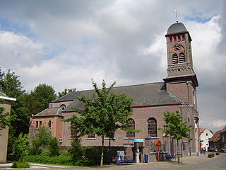
Doornzele is a village in the municipality of Evergem in the province of East Flanders, Belgium. The village is notable for its dries which is one of the largest in Belgium and in near original condition. Doornzele is located on the Ghent–Terneuzen Canal about 11 kilometres (6.8 mi) north of Ghent.
Vinderhoute is a village in the municipality of Lievegem in the province of East Flanders in Belgium. It is located in the Flemish Valley about 6 kilometres (3.7 mi) north-west of Ghent.

Zevergem is a village and deelgemeente (sub-municipality) of De Pinte in East Flanders, Belgium. It is located on the Scheldt about 8 kilometres (5.0 mi) south of Ghent.

Hansbeke is a village and deelgemeente (sub-municipality) in the municipality of Deinze in the Belgian province of East Flanders. The village is located about 13 kilometres (8.1 mi) west of Ghent.

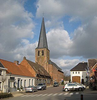
Bellem is a village and deelgemeente (sub-municipality) in the municipality of Aalter in the Belgian province of East Flanders. The village was originally called Bethlehem. Bellem is located about 16 kilometres (9.9 mi) west of Ghent.

Verrebroek is a village and deelgemeente in the municipality of Beveren in East Flanders, Belgium. Verrebroek was an independent municipality until 1 January 1977, when it merged with Beveren as part of the fusion of municipalities in Belgium.

Kieldrecht is a village and deelgemeente (sub-municipality) of Beveren in East Flanders, Belgium. Kieldrecht was an independent municipality until 1977, when it merged with Beveren as part of the fusion of municipalities in Belgium. The village is located on the border with the Netherlands, and forms a single urban area with the Dutch village of Nieuw-Namen.

Haasdonk is a village and deelgemeente (sub-municipality) of Beveren in East Flanders, Belgium. Haasdonk was an independent municipality until 1 January 1977, when it merged with Beveren as part of the fusion of municipalities in Belgium. It is located about 12 kilometres (7.5 mi) west of Antwerp.

Kallo is a village and deelgemeente (sub-municipality) of Beveren in East Flanders, Belgium. Kallo was an independent municipality until 1 January 1977, when it merged with Beveren as part of the fusion of municipalities in Belgium. Most of the deelgemeente consists of harbours and industrial zones.
Bevere is a village in the municipality of Oudenaarde. It is located in the Flemish Ardennes, the hilly southern part of the province of East Flanders, Belgium. In the mid-19th century, it started to form a single urban area with Oudenaarde, but retained some rural parts.

Zegelsem is a village in the municipality of Brakel in the province of East Flanders, Belgium. Zegelsem is an agricultural community in the Flemish Ardennes. It is located about 26 kilometres (16 mi) south of Ghent.

