Kobozha River

Last updated

Coordinates: 58°51′42″N36°17′10″E / 58.86167°N 36.28611°E / 58.86167; 36.28611

Geographic coordinate system Coordinate system

A geographic coordinate system is a coordinate system that enables every location on Earth to be specified by a set of numbers, letters or symbols. The coordinates are often chosen such that one of the numbers represents a vertical position and two or three of the numbers represent a horizontal position; alternatively, a geographic position may be expressed in a combined three-dimensional Cartesian vector. A common choice of coordinates is latitude, longitude and elevation. To specify a location on a plane requires a map projection.

Kobozha
Russian: Кобожа
Country Russia
Physical characteristics
Main source Lake Velikoye
River mouth Mologa
Length 184 km (114 mi) [1]
Discharge
  • Average rate:
    19.5 m3/s (690 cu ft/s) [1]
Basin features
Basin size 2,660 km2 (1,030 sq mi) [1]
Map of the Rybinsk Reservoir basin. The Kobozha is shown on the map. Rybinsk vdhr eng.svg
Map of the Rybinsk Reservoir basin. The Kobozha is shown on the map.

The Kobozha (Russian : Кобожа) is a river in Moshenskoy and Khvoyninsky Districts of Novgorod Oblast and in Chagodoshchensky and Ustyuzhensky Districts of Vologda Oblast in Russia. It is a left tributary of the Mologa River. It is 184 kilometres (114 mi) long, and the area of its basin 2,660 square kilometres (1,030 sq mi).

Russian language East Slavic language

Russian is an East Slavic language, which is official in the Russian Federation, Belarus, Kazakhstan and Kyrgyzstan, as well as being widely used throughout Eastern Europe, the Baltic states, the Caucasus and Central Asia. It was the de facto language of the Soviet Union until its dissolution on 25 December 1991. Although nearly three decades have passed since the breakup of the Soviet Union, Russian is used in official capacity or in public life in all the post-Soviet nation-states, as well as in Israel and Mongolia.

Moshenskoy District District in Novgorod Oblast, Russia

Moshenskoy District is an administrative and municipal district (raion), one of the twenty-one in Novgorod Oblast, Russia. It is located in the east of the oblast and borders with Khvoyninsky District in the north, Pestovsky District in the east, Lesnoy District of Tver Oblast in the southeast, Udomelsky District of Tver Oblast in the south, and with Borovichsky District in the west. The area of the district is 2,568 square kilometers (992 sq mi). Its administrative center is the rural locality of Moshenskoye. Population: 7,309 (2010 Census); 9,486 ; 10,679 (1989 Census). The population of Moshenskoye accounts for 34.3% of the district's total population.

Khvoyninsky District District in Novgorod Oblast, Russia

Khvoyninsky District is an administrative and municipal district (raion), one of the twenty-one in Novgorod Oblast, Russia. It is located in the northeast of the oblast and borders with Boksitogorsky District of Leningrad Oblast in the north, Chagodoshchensky District of Vologda Oblast in the northeast, Pestovsky District in the southeast, Moshenskoy District in the south, Borovichsky District in the southwest, and with Lyubytinsky District in the west. The area of the district is 3,200 square kilometers (1,200 sq mi). Its administrative center is the urban locality of Khvoynaya. Population: 15,552 (2010 Census); 17,173 ; 19,649 (1989 Census). The population of Khvoynaya accounts for 41.1% of the district's total population.

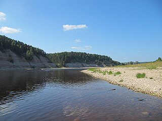
The source of the Kobozha is in Lake Velikoye in the eastern part of Moshenskoy District, in the east of the Valday Hills. The river flows in the northern direction, crosses Khvoyninsky District, passing the railway station of Kabozha, and enters Vologda Oblast, where it turns northeast, smoothly turns southeast, and enters Ustyuzhensky District. The mouth of the Kobozha is in the village of Sofrontsevo.

The river basin of the Kobozha comprises the eastern parts of Moshenskoy and Khvoyninsky Districts, as well as the southern part of Chagodoshchensky District and minor areas in Ustyuzhensky District. The areas to the west of the basin belong to the river basin of the Msta and thus to the basins of the Baltic Sea and the Atlantic Ocean. The Kobozha belongs to the basin of the Caspian Sea.

Msta River river in Russia, tributary of Lake Ilmen

The Msta is a river in Vyshnevolotsky, Udomelsky, and Bologovsky Districts of Tver Oblast and in Borovichsky, Okulovsky, Lyubytinsky, Malovishersky, Krestetsky, and Novgorodsky Districts, as well as in the town of Borovichi of Novgorod Oblast of Russia. It is a tributary of Lake Ilmen. It is 445 kilometres (277 mi) long, and the area of its basin 23,300 square kilometres (9,000 sq mi). The principal tributaries of the Msta are the Berezayka (left), the Uver (right), and the Kholova (left). The town of Borovichi and the urban-type settlement of Lyubytino are located on the banks of the Msta.

Baltic Sea A sea in Northern Europe bounded by the Scandinavian Peninsula, the mainland of Europe, and the Danish islands

The Baltic Sea is a marginal sea of the Atlantic Ocean, enclosed by Denmark, Estonia, Finland, Latvia, Lithuania, Sweden, northeast Germany, Poland, Russia and the North and Central European Plain.

Atlantic Ocean Ocean between Europe, Africa and the Americas

The Atlantic Ocean is the second largest of the world's oceans, with an area of about 106,460,000 square kilometers. It covers approximately 20 percent of the Earth's surface and about 29 percent of its water surface area. It separates the "Old World" from the "New World".

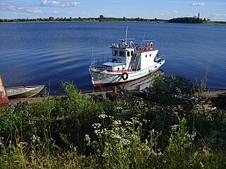
Until the 1990s, the Kobozha was used for timber rafting. [1]

Timber rafting log transportation method in which logs are tied together into rafts and drifted or pulled across a water body or down a flatter river

Timber rafting is a log transportation method in which logs are tied together into rafts and drifted or pulled across a water body or down a river. It is arguably the second cheapest method of transportation of timber, next after log driving. Both methods may be referred to as timber floating.

Related Research Articles

Mologa River river in Russia

The Mologa is a river in Maksatikhinsky, Bezhetsky, Lesnoy, and Sandovsky Districts of Tver Oblast, Pestovsky District in Novgorod Oblast, and Ustyuzhensky and Cherepovetsky Districts in Vologda Oblast Russia. It is a left tributary of the Volga River. The lower course of the Mologa has been turned into the Rybinsk Reservoir. It is 456 kilometres (283 mi) long, and the area of its basin 29,700 square kilometres (11,500 sq mi). The principal tributaries of the Mologa are the Osen (right), the Volchina (left), the Kobozha (left), the Chagodoshcha (left) and the Sit.

Sukhona River river in Russia

The Sukhona is a river in the European part of Russia, a tributary of the Northern Dvina River. The course of the Sukhona lies in Ust-Kubinsky, Sokolsky, Mezhdurechensky, Totemsky, Tarnogsky, Nyuksensky, and Velikoustyugsky Districts of Vologda Oblast in Russia. It is 558 kilometres (347 mi) long, and the area of its basin 50,300 square kilometres (19,400 sq mi). The Sukhona joins the Yug near the town of Veliky Ustyug, forming the Northern Dvina, one of the biggest rivers of European Russia.

Vologda River river in Russia

The Vologda is a river in Sheksninsky and Vologodsky Districts of Vologda Oblast as well as in the city of Vologda in Russia. A right-tributary of the Sukhona River, it is 155 kilometres (96 mi) long, and the area of its basin 3,030 square kilometres (1,170 sq mi). The principal tributary is the Toshnya (right). The river takes its name from the city of Vologda, which is located on the Vologda River.

The Uver is a river in Moshenskoy and Borovichsky Districts of Novgorod Oblast. It is a right tributary of the Msta River. It is 90 kilometres (56 mi) long, and the area of its basin 3,930 square kilometres (1,520 sq mi). The principal tributary is the Syezha (left).

Oyat River river in Leningrad Oblast, Russia

The Oyat is a river in Babayevsky District of Vologda Oblast and Podporozhsky and Lodeynopolsky Districts of Leningrad Oblast of Russia, a major left tributary of the Svir River. The length of the Oyat is 266 kilometres (165 mi), and the area of its drainage basin is 5,220 square kilometres (2,020 sq mi).

Kema River river in Russia

The Kema is a river in Vytegorsky and Vashkinsky Districts of Vologda Oblast in Russia. It flows out of Lake Kemskoye and is a tributary of Lake Beloye. It is 150 kilometres (93 mi) long, and the area of its basin 4,480 square kilometres (1,730 sq mi). The main tributary is the Indomanka River (left).

Chagoda Urban-type settlement in Vologda Oblast, Russia

Chagoda is an urban locality and the administrative center of Chagodoshchensky District of Vologda Oblast, Russia, situated on the Chagodoshcha River 326 kilometers (203 mi) from Vologda. Municipally, it is incorporated as Chagoda Urban Settlement, one of the two urban settlements in the district. Population: 6,920 (2010 Census); 7,432 (2002 Census); 8,171 (1989 Census).

Kubena River river in Russia

The Kubena is a river in Konoshsky District of Arkhangelsk Oblast and Vozhegodsky, Syamzhensky, Kharovsky, Sokolsky, and Ust-Kubinsky Districts of Vologda Oblast in Russia. It is 368 kilometres (229 mi) long, and the area of its basin 11,000 square kilometres (4,200 sq mi). The Kubena is the principal tributary of Lake Kubenskoye and belongs to the basins of the Sukhona River and the White Sea. Its main tributaries are the Syamzhena River (left) and the Sit River (right).

Kolp River river in Russia

The Kolp is a river in Boksitogorsky District of Leningrad Oblast and in Babayevsky and Kaduysky Districts of Vologda Oblast in Russia. It is a right tributary of the Suda River and belongs to the river basin of the Volga. It is 254 kilometres (158 mi) long, with a drainage basin of 3,730 square kilometres (1,440 sq mi) and an average discharge of 25.2 cubic metres per second (890 cu ft/s) measured 30 kilometres (19 mi) upstream from its mouth. Its main tributaries are the Vesyarka and the Krupen. The town of Babayevo is located by the Kolp.

Suda River river in Russia

The Suda is a river in Babayevsky, Kaduysky, and Cherepovetsky Districts of Vologda Oblast in Russia. It flows into the Rybinsk Reservoir of the Volga River. It is 184 kilometres (114 mi) long, with a drainage basin of 13,500 square kilometres (5,200 sq mi) and an average discharge of 134 cubic metres per second (4,700 cu ft/s). Its main tributaries are the Shogda, the Andoga, the Kolp, the Voron and the Petukh rivers.

Boksitogorsky District District in Leningrad Oblast, Russia

Boksitogorsky District is an administrative and municipal district (raion), one of the seventeen in Leningrad Oblast, Russia. It is located in the southeast of the oblast and borders with Tikhvinsky District in the north and west, Babayevsky District of Vologda Oblast in the east, Chagodoshchensky District of Vologda Oblast in the southeast, Khvoyninsky District of Novgorod Oblast in the south, and with Lyubytinsky District of Novgorod Oblast in the southwest. The area of the district is 7,200 square kilometers (2,800 sq mi). Its administrative center is the town of Boksitogorsk. Population : 15,695 (2010 Census); 17,698 ; 49,452 (1989 Census).

Pestovsky District is an administrative and municipal district (raion), one of the twenty-one in Novgorod Oblast, Russia. It is located in the east of the oblast and borders with Chagodoshchensky District of Vologda Oblast in the north, Ustyuzhensky District of Vologda Oblast in the northeast, Sandovsky District of Tver Oblast in the southeast, Lesnoy District of Tver Oblast in the south, Moshenskoy District in the west, and with Khvoyninsky District in the northwest. The area of the district is 2,120 square kilometers (820 sq mi). Its administrative center is the town of Pestovo. Population: 21,676 (2010 Census); 23,931 ; 25,331 (1989 Census). The population of Pestovo accounts for 73.4% of the district's total population.

Babayevsky District District in Vologda Oblast, Russia

Babayevsky District is an administrative and municipal district (raion), one of the twenty-six in Vologda Oblast, Russia. It is located in the west of the oblast and borders with Vytegorsky District in the north, Belozersky District in the east, Kaduysky District in the southeast, Ustyuzhensky District in the south, Chagodoshchensky District in the southeast, and with Boksitogorsky, Tikhvinsky, and Podporozhsky Districts of Leningrad Oblast in the west. The area of the district is 9,200 square kilometers (3,600 sq mi). Its administrative center is the town of Babayevo. Population: 21,944 (2010 Census); 24,930 ; 29,535 (1989 Census). The population of Babayevo accounts for 55.0% of the district's total population.

Chagodoshchensky District District in Vologda Oblast, Russia

Chagodoshchensky District is an administrative and municipal district (raion), one of the twenty-six in Vologda Oblast, Russia. It is located in the southwest of the oblast and borders with Babayevsky District in the northeast, Ustyuzhensky District in the southeast, Pestovsky District of Novgorod Oblast in the south, Khvoyninsky District of Novgorod Oblast in the southwest, and with Boksitogorsky District of Leningrad Oblast in the northwest. The area of the district is 2,400 square kilometers (930 sq mi). Its administrative center is the urban locality of Chagoda. Population: 13,865 (2010 Census); 15,624 ; 17,866 (1989 Census). The population of Chagoda accounts for 49.9% of the district's total population.

Chagodoshcha River river in Leningrad and Vologda Oblasts, Russia

The Chagodoshcha is a river in Boksitogorsky District of Leningrad Oblast and in Chagodoshchensky, Babayevsky, and Ustyuzhensky Districts of Vologda Oblast in Russia. It is a left tributary of the Mologa River. It is 242 kilometres (150 mi) long, and the area of its basin 9,680 square kilometres (3,740 sq mi). The principal tributaries are the Lid (left), the Pes (right), and the Vnina (left).

Pes River river in Khvoyninsky District of Novgorod Oblast and in Chagodoshchensky District of Vologda Oblast in Russia

The Pes is a river in Khvoyninsky District of Novgorod Oblast and in Chagodoshchensky District of Vologda Oblast in Russia. It is a right tributary of the Chagodoshcha River. It is 145 kilometres (90 mi) long, and the area of its basin 2,730 square kilometres (1,050 sq mi). The principal tributary of the Pes is the Rattsa River (left). The urban-type settlements of Khvoynaya and Sazonovo are located on the banks of the Pes.

Kabozha is the name of several rural localities in Russia:

Oryol, alternatively spelled Orel, is the name of several inhabited localities in Russia.

References

  1. 1 2 3 4 Кобожа. Great Soviet Encyclopedia.