
Kulob, also Kulyab, is a city in Kulob District, Khatlon Province, Tajikistan. Located 203 km south-east of the capital Dushanbe on the Yakhsu River, it is one of the largest cities in the country and has an estimated population of 100,000. The town is served by Kulob Airport.
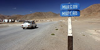
Murghab is the capital of Murghob District in the Pamir Mountains of Gorno-Badakhshan Autonomous Region, Tajikistan. With a population of 4,000, Murghab is about the only significant town the eastern half of Gorno-Badakhshan. It is the highest town in Tajikistan at 3,650 m above sea level. It located at the junction of the Murghab River and the Pamir Highway.

Rumi District or Nohiya-i Rumi, formerly Kolkhozobod District or Nohiya-i Kolkhozobod, is a district in Khatlon province, Tajikistan, located south of the provincial capital Kurgan-Tyube (Qurghonteppa) and Vakhsh district. It was renamed Rumi District on 23 June 2007 in commemoration of the 800th anniversary of the Persian poet and philosopher Rumi and plans were announced to erect a monument to Rumi in the district.

Jomi District is a district in Khatlon Province of Tajikistan, located north of the provincial capital Kurgan-Tyube (Qurghonteppa). Population 109,200. Called Kuybyshevskiy District in Soviet times, then Hojamaston District until 2004, and finally renamed Dzhami District in honor of the 15th century Persian Poet Abdurahman Jami. The district capital is still listed as Kuybyshev or Kuybyshevsk.

Yovon is a town in Tajikistan located in the Khatlon province. In 2000, the town had an estimated population of 20,000. It is approximately 30 kilometres (20 mi) southeast of Dushanbe.

Vahdat District is one of the larger districts of the Districts of Republican Subordination in Tajikistan, called Kofarnihon District until the introduction of a new administrative division in the end of 2003. During the Soviet period it was named Ordzhonikidzeabad district in honor of Georgian communist Grigoriy Ordzhonikidze. It extends east of Dushanbe along the southern slopes of the Gissar Range, bordering on Varzob District from the west and Rasht District from the east. Its long southern border runs along Khatlon Province and then Faizobod, Roghun, and Nurobod districts. The district capital Vahdat is placed off-center at the extreme southwest of the district, just 10 km east of Dushanbe.

' Khuroson District', formerly Ghozimalik District, is a district in Khatlon province of Tajikistan extending south from national capital Dushanbe toward the provincial capital Kurgan-Tyube (Qurghonteppa). The district population is 73,100. Ghozimalik District was renamed Khuroson District around 2003, and its capital was renamed at about that time from Pravda to Obikiik.
Temurmalik District or Nohiya-i Temurmalik is a district in the Khatlon province of Tajikistan, located south of the Vakhsh Range along the middle course of Kyzylsu River. It had an estimated population of 57,700 as of 2008. Before 1957, it was called Qizil-Mazor District or Kzyl-Mazar District, then renamed Sovetskiy District, and in 2004 given its present name Temurmalik District. The new name honors a medieval military hero, Timur Malik, who in 1220 led the people of Khujand in their struggle against the Mongol occupation.

Nosiri Khusrav District, sometimes Nosiri Khisrav District, is located in the south-western corner of Khatlon province of Tajikistan on the Amu Darya, an enclave within the Shahrtuz district. Population 27,400. Until 2004 called Beshkent District ; then renamed in honor of the 11th century Persian-Tajik poet Nosiri Khusrav. The district capital is Bakhori, a village at the northernmost tip of the district.
Beshkent is a lowland 70 kilometers in length and 5 kilometers in width—dry without any reliable source of water. beshkent is the warmest valley in Tajikistan, with average temperatures in January and July of 3 °C and 31 °C respectively. The annual average precipitation is 140 millimeters.

Hamadoni District is a district in the south-east of Khatlon Province of Tajikistan, located south of Kulob and stretching along a section of the Panj on the border with Afghanistan. Population 123,800. Between 1950 and 2004 called Moskovskiy District, then renamed in honor of Mir Sayyid Ali Hamadani, a 14th-century Persia Great Islamic preacher,Traveller, poet, and scholar who preached Islam in different parts of world, and is buried in Khatlon.
Levakant, Kalininabad (Калилининобод) until February 1996, Sarband (Сарбанд) until January 2018, is a city in south-west Tajikistan. It is the administrative capital of Sarband district in Khatlon Province, located just east of the provincial capital Bokhtar and about 120 km south of the national capital Dushanbe. The Golovnaya Dam on the Vakhsh River lies directly to its east.
Roghun is a town in Tajikistan. It is the administrative capital of Roghun district in the central part of the Region of Republican Subordination.

Obigarm is a town in Tajikistan, located in Roghun district in the central part of the Region of Republican Subordination, just north of the district capital of Roghun.
Kuybyshevsk or Kuybyshev is a location in south-west Tajikistan. It is the administrative capital of Jomi district in Khatlon Province, located just north of the provincial capital Qurghonteppa and about 100 km south of the national capital Dushanbe.
Mu'minobod, also known as Muminabad, Leningradskiy or Leningrad is a location in south Tajikistan. It is the administrative capital of the Muminobod District in the eastern part of Khatlon Province, located north-east of the city of Kulob, not far from the Panj River and the international border with Afghanistan.
Moskovskiy or Moskva is a location in Tajikistan. It is the administrative capital of Hamadoni district in Khatlon Province, located at 37°39′24″N69°37′45″E. Its population is 20,700.
Obikiik, formerly Pravda, is a location in Tajikistan. It is the administrative capital of Khuroson district in Khatlon Province, located at 38.158611°N 68.6722222°E. Its population is 6,200.
Hulbuk is the capital of the Vose' District of the Khatlon Province, Tajikistan. In 2000 the population was approximately 20,000. It is located in the southern portion of Tajikistan 26 kilometres (16 mi) southwest of Kulob and 174 km (108 mi) south of Dushanbe.
Jilikul is the capital of the Jilikul District of the Khatlon Province, Tajikistan. It is located in the southwestern portion of Tajikistan approximately 117km from Dushanbe.
The 2018 Tajik League is the 27th season of Tajik League, Tajikistan's top division of association football. The season began on 10 March 2018.

