
Himachal Pradesh is a state in the northern part of India. Situated in the Western Himalayas, it is one of the thirteen mountain states and is characterized by an extreme landscape featuring several peaks and extensive river systems. Himachal Pradesh is the northernmost state of India and shares borders with the union territories of Jammu and Kashmir and Ladakh to the north, and the states of Punjab to the west, Haryana to the southwest, Uttarakhand to the southeast and a very narrow border with Uttar Pradesh to the south. The state also shares an international border to the east with the Tibet Autonomous Region in China. Himachal Pradesh is also known as Dev Bhoomi, meaning 'Land of Gods' and Veer Bhoomi which means 'Land of the Brave'.
Matteson is a village in Cook County, Illinois, United States. The population was 19,073 at the 2020 census. It is a suburb of Chicago.

Shimla is the capital and the largest city of the northern Indian state of Himachal Pradesh. In 1864, Shimla was declared as the summer capital of British India. After independence, the city became the capital of East Punjab and was later made the capital city of Himachal Pradesh. It is the principal commercial, cultural and educational centre of the state.

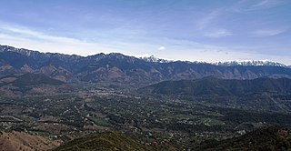
Kullu is a district in Himachal Pradesh, India. It borders Shimla district to the south, Mandi and Kangra districts to the west, and the Lahaul and Spiti district to the north and east. The largest valley in this mountainous district is the Kullu Valley. The Kullu valley follows the course of the Beas River, and ranges from an elevation of 833m above sea level at Aut to 3330m above sea level at the Atal Tunnel South Portal, below the Rohtang Pass. The town of Kullu, located on the right side of the Beas River, serves as the administrative headquarters of the Kullu district. The Kullu district also incorporates several riverine tributary valleys of the Beas, including those of the Parvati, Sainj, and Tirthan rivers, and thus some regions somewhat distant from the Kullu valley. The economy of the district relies mainly on horticulture, agriculture, tourism, and traditional handicrafts.

The Lahaul and Spiti district in the Indian state of Himachal Pradesh consists of the two formerly separate districts of Lahaul and Spiti. The present administrative center is Kyelang in Lahaul. Before the two districts were merged, Kardang was the capital of Lahaul, and Dhankar the capital of Spiti. The district was formed in 1960 and is the fourth least populous district in India. It is the least densely populated district of India, according to the Census of India 2011.

Manali is a town, near Kullu town in Kullu district in the Indian state of Himachal Pradesh. It is situated in the northern end of the Kullu Valley, formed by the Beas River. The town is located in the Kullu district, approximately 270 kilometres (170 mi) north of the state capital of Shimla and 544 kilometres (338 mi) northeast of the national capital of New Delhi. With a population of 8,096 people recorded in the 2011 Indian census Manali is the beginning of an ancient trade route through Lahaul (H.P) and Ladakh, over the Karakoram Pass and onto Yarkand and Hotan in the Tarim Basin of China. Manali is a popular tourist destination in India and serves as the gateway to the Lahaul and Spiti district as well as the city of Leh in Ladakh.


Faridabad is the most populous city in the Indian state of Haryana and a part of Delhi National Capital Region. It is one of the major satellite cities around Delhi and is located 284 kilometres south of the state capital Chandigarh. The river Yamuna forms the eastern district boundary with Uttar Pradesh. The Government of India included it in the second list of Smart Cities Mission on 24 May 2016. Faridabad has been described as the eighth fastest growing city in the world and the third in India by the City Mayors Foundation survey. As per the 2021 Delhi Regional Plan, Faridabad is a part of the (CNCR) Central National Capital Region or (DMA) Delhi metropolitan area.

East Khasi Hills is an administrative district in the state of Meghalaya in India. The district headquarters are located at Shillong. The district occupies an area of 2752 km² and has a population of 825,922. As of 2011, it is the most populous district of Meghalaya's 12 districts.
Jogindernagar, or Jogindar Nagar, is a municipality, and a sub district in Mandi district in the Indian state of Himachal Pradesh. Named after Raja Joginder Sen, the hill station is the terminus of the 163-kilometre-long (101 mi) Kangra Valley narrow-gauge railway. Jogindernagar is the third-largest city in the Mandi district. The only city in Asia with three hydro-electric power stations, its nickname is "The City of Powerhouses".

Spiti is a high-altitude region of the Himalayas, located in the north-eastern part of the northern Indian state of Himachal Pradesh. The name "Spiti" means "The middle land", i.e. the land between Tibet and India. Spiti incorporates mainly the valley of the Spiti River, and the valleys of several rivers that feed into the Spiti River. Some of the prominent side-valleys in Spiti are the Pin valley and the Lingti valley. Spiti is bordered on the east by Tibet, on the north by Ladakh, on the west and southwest by Lahaul, on the south by Kullu, and on the southeast by Kinnaur. Spiti has a cold desert environment. The valley and its surrounding regions are among the least populated regions of India. The Bhoti-speaking local population follows Tibetan Buddhism.

Kye Gompa is a Tibetan Buddhist monastery of the Gelugpa sect located on top of a hill at an altitude of 4,166 metres (13,668 ft) above sea level, close to the Spiti River, in the Spiti Valley of Himachal Pradesh, Lahaul and Spiti district, India.
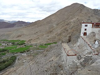
Nyoma is a principal village of southern Ladakh in India, the headquarters of an eponymous subdivision, tehsil, community development block and Indian Air Force Base in the Leh district. It is located on the bank of the Indus river after its 90-degree bend near Dungti east of Nyoma and before the valley narrows to a gorge near Mahe northwest of Nyoma. The Nyoma tehsil and subdivision cover all of southern Ladakh, including the Rupshu plains south of Nyoma, the Indus valley of Skakjung north of Nyoma, and the Hanle valley. Nyoma gompa, a Buddhist monastery, is located on the hill slope north of the village.

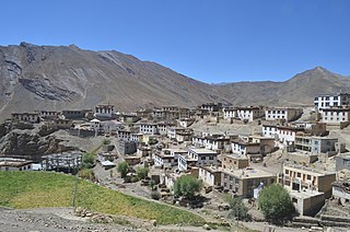
Kaza, also spelled Kaze, Karze, Karzey, is a town and the subdivisional headquarters of the remote Spiti Valley in the western Himalayas in the Lahaul and Spiti district of the northern Indian state of Himachal Pradesh. Spiti is a high altitude or cold desert having close similarities to the neighbouring Tibet and Ladakh regions in terms of terrain, climate and the Buddhist culture. Kaza, situated along the Spiti River at an elevation of 3,650 m (11,980 ft) above mean sea level, is the largest township and commercial center of the Spiti valley.
Kibber, also Kibber Khas and Khyipur, is a village high in the Spiti Valley in the Himalayas at 4,270 m (14,010 ft) in Himachal Pradesh in northern India. It contains a monastery and is a base for visiting the Kibber Wildlife Sanctuary. It is located 19 km (12 mi) from Kaza and a bus service connects them in the summer months. Agriculture forms the backbone of the local economy and lush green fields are abundant. It is the base for visitors to the Kibber Wildlife Sanctuary, home to about 30 snow leopards. Treks to neaby peaks and to a high pass in the Zanskar range between Spiti and Ladakh start from Kibber.

Hikkim is a village in Lahaul and Spiti district in the northern Indian state of Himachal Pradesh at an elevation of 4,400 m (14,400 ft). It is 46 km (29 mi) from Kaza, the nearest town connected by road. It is one of the highest year-round inhabited locations in India, with residences from 4330 to 4400 m. Tangyud Monastery in adjacent Komic village 2 km to the southeast has residences up to 4520 m, and Korzok Monastery in adjacent Korzok village on Tso Moriri has year-round residences up to 4570 m. Most of the population is Buddhist. People use stones and wood extensively to build houses and structures.

Losar Khas or Losar is a village on the right bank of the Spiti River in District Lahaul Spiti in the state of Himachal Pradesh, India. The Losar Gram Panchayat located in Losar is a local government body for the village of Losar Khas and 12 nearby villages in Development Block Spiti. Losar is located on NH-505 between Kaza in Spiti and Gramphoo in Lahaul.

Mud is a small village in the cold desert region of Spiti in Himachal Pradesh, India. Located at an altitude of 3,810 m (12,500 ft) on the left bank of the Pin River, a right bank tributary of the Spiti River, the village nestles at the base of the Parbati range that towers almost vertically 1,600 m (5,200 ft) above. Mud is near the boundary of the Pin Valley National Park and is a convenient base for treks in the park, and to the neighbouring districts of Kullu and Kinnaur. It is the last village on the Spiti side of the Pin Parbati trek to Kullu and the Pin Bhaba trek to Kinnaur.
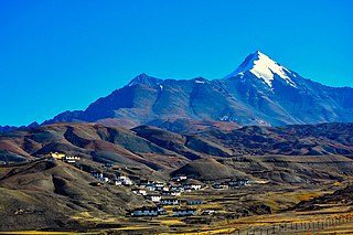
Langza is a small village located in Spiti Tehsil of Lahaul and Spiti district, Himachal Pradesh. It is set at the base of Chau Chau Kang Nilda mountain, also known as the Princess Mountain.


