
Dalmatia is one of the four historical regions of Croatia, alongside Central Croatia, Slavonia and Istria, located on the east shore of the Adriatic Sea in Croatia.

Dubrovnik, historically known as Ragusa, is a city in southern Dalmatia, Croatia, by the Adriatic Sea. It is one of the most prominent tourist destinations in the Mediterranean, a seaport and the centre of the Dubrovnik-Neretva County. Its total population is 41,562. In 1979, the city of Dubrovnik was added to the UNESCO list of World Heritage Sites in recognition of its outstanding medieval architecture and fortified old town.

Ston is a settlement and a municipality in the Dubrovnik-Neretva County of Croatia, located at the south of isthmus of the Pelješac peninsula.

Korčula is a Croatian island in the Adriatic Sea. It has an area of 279 km2 (108 sq mi), is 46.8 km (29.1 mi) long and on average 7.8 km (4.8 mi) wide, and lies just off the Dalmatian coast. Its 15,522 inhabitants (2011) make it the second most populous Adriatic island after Krk. The population are almost entirely ethnic Croats (95.74%). The island is twinned with Rothesay in Scotland. It is known for Grk, a white wine that is only produced here and not exported due to limited production.

Metković is a town in the Dubrovnik-Neretva County of Croatia, located in the southeast of the country, on the banks of the river Neretva and on the border with Bosnia and Herzegovina.

Lopud is a small island off the coast of Dalmatia, southern Croatia. Lopud is economically the most developed of the Elaphiti Islands, and can be reached by boat from Dubrovnik, Trsteno, Orašac and Zaton. The island is famous for its sandy beaches, in particular the bay of Šunj. Lopud is the second largest island of the Elaphiti islands, between Koločep and Šipan. It is famous as the "island in the middle". It has an area of 4.63 square kilometres and its highest point is Polačica, 216 metres above sea level. It has 11.5 km (7 mi) of coastline, of which 1.2 km (1 mi) is sandy.

Kaštela is a town and a suburb of Split, in Split-Dalmatia County. The town is an agglomeration of seven individual settlements which are administered as a single municipality with populations individually ranging from 3,000 to 7,000 residents. The town is located northwest of the city of Split, west of Solin and east of Trogir, on the central Dalmatian coast. With a total population of 37,794 as of 2021 census, it is the 14th largest town in the country.
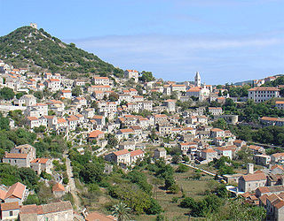
Lastovo is an island municipality in the Dubrovnik-Neretva County in Croatia. The municipality consists of 46 islands with a total population of 792 people, of which 94,7% are ethnic Croats, and a land area of approximately 53 square kilometres (20 sq mi). The biggest island in the municipality is also named Lastovo, as is the largest town. The majority of the population lives on the 46 square kilometres (18 sq mi) island of Lastovo.

Orašac is a village in southern Croatia, administratively located in the City of Dubrovnik. It is located between Trsteno and Zaton, northwest of Dubrovnik.
Koločep is one of the three inhabited Elaphiti Islands situated near the city of Dubrovnik with an area of 2.44 square kilometres. Koločep is the southernmost inhabited island in Croatia. According to the 2021 census, its population was 231. In the 2011 census, the population of the island was 163.
Brsečine is a village in southern Croatia, administratively located in the City of Dubrovnik, about 1 km from the cove bearing the same name, and 25 km northwest of Dubrovnik. Brsečine is protected from cold, northerly winds by the limestone crests of Kondulo.

Slano is a village in southern Croatia with a small harbour in the bay of the same name. It is located 27 km northwest of Dubrovnik.

Zaton is a village in southern Croatia, administratively located in the City of Dubrovnik. It is located on the coast of the eponymous bay, 8 km northwest of Dubrovnik, next to the village of Orašac. Chief occupations are tourism, fishing farming, viticulture, and olive growing.

Cavtat is a village in the Dubrovnik-Neretva County of Croatia. It is on the Adriatic Sea coast 15 kilometres south of Dubrovnik and is the centre of the Konavle municipality.

Orebić is a port town and municipality in the Dubrovnik-Neretva county in Croatia. It is located on the Pelješac peninsula on the Dalmatian coast. Orebić is directly across a strait from the town of Korčula, located on the island of the same name. Ferries service the two towns frequently. Orebić is 112 km (70 mi) from Dubrovnik.

Lovište or Lovišće is small seaside town located in a cove near the western tip of the Pelješac peninsula in the Dubrovnik-Neretva county in Croatia. It has a population of 228. As it is situated at the very end of the peninsula, it was isolated before a road to the town was built, connecting it to Nakovana and beyond.

Mokošica is a district in the city of Dubrovnik in Croatia. The suburb consists of Old (Mokošica) and New Mokošica.

Rožat is a small village near Dubrovnik, Croatia.

The Ombla is a short river in Croatia, northeast of Dubrovnik. Its course is approximately 30 metres long, and it empties into the Rijeka Dubrovačka, ria formed by the Adriatic Sea near Komolac in Dubrovnik-Neretva County. Rijeka Dubrovačka is actually a ria, a flooded river valley formed through changes in sea surface elevation on a geologic time scale. The river rises as a karst spring fed by groundwater replenished by Trebišnjica, which is an influent stream flowing in Popovo Polje, in the immediate hinterland of the Ombla. The elevation difference between the river's source and its mouth is just over 2 metres. The average discharge of the river is 24.1 cubic metres per second. The drainage basin of the Ombla encompasses 600 square kilometres and, besides the short surface course, includes only groundwater flow.


