Kongsfjorden Bird Sanctuary

Last updated
Kongsfjorden Bird Sanctuary
Kongsfjorden fuglereservat

Kongsfjorden from Blomstrandhalvoja.jpg

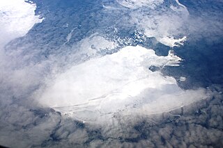
Kongsfjorden viewed from Blomstrandhalvøya
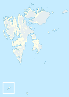
Location Spitsbergen, Svalbard, Norway
Nearest town Ny-Ålesund
Coordinates 78°55′N12°10′E / 78.917°N 12.167°E / 78.917; 12.167
Area 7.1 km2 (2.7 sq mi), of which
1.4 km2 (0.54 sq mi) is land
Established July 1, 1973 (1973-07-01)
Governing body Norwegian Directorate for Nature Management
The sanctuary is an important breeding site for King Eiders King Eiders.jpg
The sanctuary is an important breeding site for King Eiders

Kongsfjorden Bird Sanctuary (Norwegian : Kongsfjorden fuglereservat) is a 140  ha bird reserve at Svalbard, Norway, established in 1973. [1] It includes islands and islets in Kongsfjorden, Haakon VII Land. [2] It lies at the inner end of the fjord and consists of about ten islands, mainly covered with grassy vegetation and having small freshwater ponds. The fjord is surrounded by steep mountains, cliffs, glaciers and tundra. The reserve has been recognised as a wetland of international importance by designation under the Ramsar Convention. It has also been identified as an Important Bird Area (IBA) by BirdLife International. It supports breeding populations of pink-footed and barnacle geese, common and king eiders, long-tailed ducks, purple sandpipers, red phalaropes, glaucous gulls, long-tailed jaegers and snow buntings. Ivory gulls have been recorded. [3]

Norwegian language North Germanic language spoken in Norway

Norwegian is a North Germanic language spoken mainly in Norway, where it is the official language. Along with Swedish and Danish, Norwegian forms a dialect continuum of more or less mutually intelligible local and regional varieties, and some Norwegian and Swedish dialects, in particular, are very close. These Scandinavian languages, together with Faroese and Icelandic as well as some extinct languages, constitute the North Germanic languages. Faroese and Icelandic are hardly mutually intelligible with Norwegian in their spoken form because continental Scandinavian has diverged from them. While the two Germanic languages with the greatest numbers of speakers, English and German, have close similarities with Norwegian, neither is mutually intelligible with it. Norwegian is a descendant of Old Norse, the common language of the Germanic peoples living in Scandinavia during the Viking Era.

Hectare metric unit of area

The hectare is an SI accepted metric system unit of area equal to a square with 100-metre sides, or 10,000 m2, and is primarily used in the measurement of land. There are 100 hectares in one square kilometre. An acre is about 0.405 hectare and one hectare contains about 2.47 acres.

Bird reserve naturally occurring sanctuary designed to protect bird species

A bird reserve is a wildlife refuge designed to protect bird species. Like other wildlife refuges, the main goal of a reserve is to prevent species from becoming endangered or extinct. Typically, bird species in a reserve are protected from hunting and habitat destruction. Because of the protection they provide from such threats, bird reserves also serve as excellent locations for bird watching. Normally, wildlife refuges are under the care of non-profit organizations and governmental institutions.


Related Research Articles

Kongsfjorden fjord in Svalbard

Kongsfjorden is an inlet on the west coast of Spitsbergen, an island which is part of the Svalbard archipelago in the Arctic Ocean. The inlet is 26 km (16 mi) long and ranges in width from 6 to 14 km. Two glaciers, Kronebreen and Kongsvegen, head the fjord.

Nordaust-Svalbard Nature Reserve nature reserve

Nordaust-Svalbard Nature Reserve is located in the north-eastern part of the Svalbard archipelago in Norway. The nature reserve covers all of Nordaustlandet, Kong Karls Land, Kvitøya, Sjuøyane, Storøya, Lågøya, Wilhelm Island, Wahlbergøya and a small section of the north-east corner of Spitsbergen. The reserve is 55,354 square kilometres (21,372 sq mi), of which 18,663 square kilometres (7,206 sq mi) is on land and 36,691 square kilometres (14,166 sq mi) is on water—making it the largest preserved area in Norway. It includes the largest glacier in Norway, Austfonna, as well as Vestfonna and parts of Olav V Land. The reserve has been protected since 1 July 1973 and borders in the south to Søraust-Svalbard Nature Reserve.

Søraust-Svalbard Nature Reserve

Søraust-Svalbard Nature Reserve is located in the south-eastern part of the Svalbard archipelago in Norway. The nature reserve covers all of Edgeøya and Barentsøya in addition to a number of smaller islands, including Thousand Islands, Ryke Yseøyane and Halvmåneøya. The reserve is 21,825 square kilometres (8,427 sq mi), of which 6,400 square kilometres (2,500 sq mi) is on land and 15,426 square kilometres (5,956 sq mi) is on water—making it the second-largest preserved area in Norway. The reserve has been protected since 1 July 1973 and borders in the north to Nordaust-Svalbard Nature Reserve.

Oscar II Land land area between Isfjorden and Kongsfjorden on Spitsbergen, Svalbard

Oscar II Land is the land area between Isfjorden and Kongsfjorden on Spitsbergen, Svalbard. The 30 km (19 mi) long glacier Sveabreen divides Oscar II Land from James I Land.

Nordenskiöld Land land area between Isfjorden and Van Mijenfjorden on Spitsbergen, Svalbard

Nordenskiöld Land is the land area between Isfjorden and Van Mijenfjorden on Spitsbergen, Svalbard. The area is named after Finnish-Swedish explorer and geologist Nils Adolf Erik Nordenskiöld. The coastal region of Nordenskiöld Land (Nordenskiøldkysten) has been identified as an Important Bird Area (IBA) by BirdLife International because it supports breeding populations of barnacle geese and common eiders.

Blomstrandhamna Bird Sanctuary is a bird reserve at Svalbard, Norway, established in 1973. It includes the skerry in Blomstrandhamna in Haakon VII Land. The protected area covers a total of 580,000 square metres.

Boheman Bird Sanctuary is a bird reserve in Svalbard, Norway, established in 1973. It includes islands south of Bohemanflya in Oscar II Land. The protected area covers a total of 2,076,000 square metres.

Dunøyane Bird Sanctuary is a bird reserve in Svalbard, Norway, established in 1973. It includes islands west of Dunøysundet in Wedel Jarlsberg Land. The protected area covers a total of around 11.9 km2.

Forlandsøyane Bird Sanctuary is a bird reserve at Svalbard, Norway, established in 1973. It includes Forlandsøyane off Prins Karls Forland. The protected area covers a total area of around 5,400,000 square metres.

Guissezholmen Bird Sanctuary is a bird reserve at Svalbard, Norway, established in 1973. It includes islets at Kapp Guissez in Haakon VII Land. The protected area covers a total area of around 400,000 square metres.

Hermansen Island Bird Sanctuary

Hermansen Island Bird Sanctuary is a bird reserve at Svalbard, Norway, established in 1973. It includes Hermansen Island on the west coast of Oscar II Land. The protected area covers a total area of around 4,200,000 square metres.

Isøyane Bird Sanctuary is a bird reserve at Svalbard, Norway, established in 1973. It includes Nordre Isøya and Isøykalven in the Isøyane island group in Wedel Jarlsberg Land. The protected area covers a total area of around 2,300,000 square metres.

Moseøya Bird Sanctuary is a bird reserve at Svalbard, Norway, established in 1973. It includes Moseøya, south of Danes Island, part of Albert I Land. The protected area covers a total area of around 1,400,000 square metres.

Plankeholmane Bird Sanctuary is a bird reserve at Svalbard, Norway, established in 1973. It includes Plankeholmane south of Prins Karls Forland, Spitsbergen. The protected area covers a total area of around 1,600,000 square metres.

Skorpa Bird Sanctuary is a bird reserve at Svalbard, Norway, established in 1973. It includes islets off Harpunodden in Albert I Land, Spitsbergen. The protected area covers a total area of around 1,100,000 square metres.

Sørkapp Bird Sanctuary

Sørkapp Bird Sanctuary is a bird reserve at Svalbard, Norway, established in 1973. It includes Sørkappøya and other islands off Sørkapp Land, Spitsbergen. The protected area covers a total area of 3,599ha

Blomstrandhalvøya island in Norway

Blomstrandøya is an island at the western side of Spitsbergen, Svalbard. It is located in Kongsfjorden, near the northern side of the fjord, and has a roughly circular shape with a cross section of about 5 km. The island was originally believed to be a peninsula, when the glacier Blomstrandbreen extended onto the island. The highest mountain is Irgensfjellet 385 m.a.s.l. The former peninsula has an area of 16,4 km2.

Lovénøyane island in Svalbard, Norway

Lovénøyane is a group of seven islands and islets in Kongsfjorden in Haakon VII Land at Spitsbergen, Svalbard. They are named after Swedish zoologist Sven Ludvig Lovén. The largest of the islands is Storholmen, and the six others are Juttaholmen, Observasjonsholmen, Sigridholmen, Midtholmen, Innerholmen and Leirholmen.

Prins Heinrichøya is an island in Zeppelinhamna at the southern side of Kongsfjorden in Oscar II Land, at Spitsbergen, Svalbard. It is named after Prince Heinrich of Prussia. Prins Heinrichøya, as well as the seven Lovénøyane, Mietheholmen and Eskjeret were included in the Kongsfjorden Bird Sanctuary in 1973.

References

  1. "Forskrift om opprettelse av nasjonalparker, naturresevater og fuglereservater, Svalbard" (in Norwegian). Lovdata . Retrieved 27 November 2011.
  2. "Kongsfjorden fuglereservat (Svalbard)". Norwegian Polar Institute . Retrieved 27 November 2011.
  3. "Inner parts of Kongsfjorden". Important Bird Areas factsheet. BirdLife International. 2013. Retrieved 2013-08-22.

Coordinates: 78°55′N12°32′E / 78.917°N 12.533°E / 78.917; 12.533

Geographic coordinate system Coordinate system

A geographic coordinate system is a coordinate system that enables every location on Earth to be specified by a set of numbers, letters or symbols. The coordinates are often chosen such that one of the numbers represents a vertical position and two or three of the numbers represent a horizontal position; alternatively, a geographic position may be expressed in a combined three-dimensional Cartesian vector. A common choice of coordinates is latitude, longitude and elevation. To specify a location on a plane requires a map projection.