
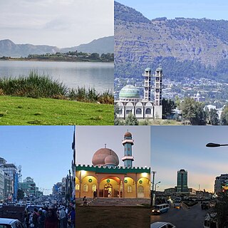
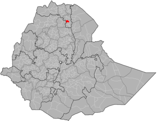
The Tigray Region, officially the Tigray National Regional State, is the northernmost regional state in Ethiopia. The Tigrai Region is the homeland of the Tigrayan (Tegaru), Irob people and Kunama people. Its capital and largest city is Mekelle. Tigray is the fifth-largest by area, the fourth-most populous, and the fifth-most densely populated of the 11 regional states.
The Battle of Maychew was the last major battle fought on the northern front during the Second Italo-Abyssinian War. The battle consisted of a failed counterattack by the Ethiopian forces under Emperor Haile Selassie making frontal assaults against prepared Italian defensive positions under the command of Marshal Pietro Badoglio. The battle was fought near Maychew, Ethiopia, in the modern region of Tigray.

Adwa is a town and separate woreda in Tigray Region, Ethiopia. It is best known as the community closest to the site of the 1896 Battle of Adwa, in which Ethiopian soldiers defeated Italian troops, thus being one of the few African nations to thwart European colonialism. Located in the Central Zone of the Tigray Region, Adwa has a longitude and latitude of 14°10′N38°54′E, and an elevation of 1907 meters. Adwa is surrounded by Adwa woreda.
Dessie is a town in north-central Ethiopia. Located in the South Wollo Zone of the Amhara Region, it sits at a latitude and longitude of 11°8′N39°38′E, with an elevation between 2,470 and 2,550 metres above sea level. Dessie is 400 km to the north of the capital Addis Ababa. It has a population of more than 200,000 people in over 30 wards.

Kombolcha is a town and district in north-central Ethiopia. Located in the Debub Wollo Zone of the Amhara Region, it has a latitude and longitude of 11°5′N39°44′E with an elevation between 1842 and 1915 meters above sea level. Some guide books describe Kombolcha as the twin town of Dessie which lies some 12 kilometres (7.5 mi) to the northwest.

Adigrat is a city and separate woreda in Tigray Region of Ethiopia. It is located in the Misraqawi Zone at longitude and latitude 14°16′N39°27′E, with an elevation of 2,457 metres (8,061 ft) above sea level and below a high ridge to the west. Adigrat is a strategically important gateway to Eritrea and the Red Sea. Adigrat was part of Ganta Afeshum woreda before a separate woreda was created for the city. Currently, Adigrat serves as the capital of the Eastern Tigray zone.
Maychew, also Maichew, is a town and woreda in the Tigray Region of Ethiopia. It is located at 665 km north of Addis Ababa along Ethiopian Highway 2. According to Ethiopia’s agro-ecological setting, Maychew and its environs are classified under the Weinadega. Maychew is located in the endoreic basin of the Afar Triangle. The streams near Maychew do not reach the ocean.

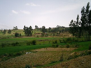
Lake Hashenge is a lake in the southern Tigray Region of Ethiopia. Located in the Ethiopian highlands at an elevation of 2409 meters, it has no outlet. According to the Statistical Abstract of Ethiopia for 1967/68, Lake Hashenge is five kilometers long and four wide, with a surface area of 20 square kilometers.

Welkait is a woreda in Western Zone, Tigray Region. This woreda is bordered to the north by Humera and to the south by Tsegede. It is bordered on the east by the North West Zone; the woredas of Tahtay Adiyabo and Asgede Tsimbla lie to the north-east, on the other side of the Tekezé River, and Tselemti to the east. The administrative center of Welkait is Addi Remets; other towns in the woreda include Mai'gaba and Awura.

Saesi Tsaedaemba is one of the Districts of Ethiopia, or woredas, in the Tigray Region of Ethiopia. Located in the Misraqawi Zone at the eastern edge of the Ethiopian highlands, Saesi Tsaedaemba is bordered on the south by Kilte Awulaelo, on the southwest by Hawzen, on the west by Ganta Afeshum, on the northwest by Gulomahda, on the north by Irob, on the east by the Afar Region, and on the southeast by Atsbi Wenberta. Towns in Saesi Tsaedaemba include Edaga Hamus and Freweyni also known as Sinkata) where the woreda office is located.
Alaje is a District of Ethiopia, or woreda, in the Tigray Region of Ethiopia. Part of the Debubawi Zone, Alaje is bordered on the south by Endamehoni, on the southwest by the Amhara Region, on the north by Debub Misraqawi (Southeastern) Zone, and on the southeast by Raya Azebo. The administrative center of this woreda is Adi Shehu; other towns in Alaje include Bora and Dela.

Endamekoni is one of the Districts of Ethiopia, or woredas, in the Tigray Region of Ethiopia. Part of the Debubawi Zone, Endamehoni is bordered on the south by Ofla, on the west by the Amhara Region, on the north by Alaje, and on the east by Raya Azebo. Towns in Endamehoni include Wedisemro. The town of Maychew is surrounded by Endamehoni.
Alamata is a woreda in Tigray Region, Ethiopia. Part of the Debubawi Zone, Alamata is bordered on the south and west by the Amhara Region, on the northwest by Ofla, and on the northeast by Raya Azebo. Towns in Alamata include Waja. The city of Alamata is a separate entity and is surrounded by Alamata woreda.

Ofla is one of the Districts of Ethiopia, or woredas, in the Tigray Region of Ethiopia. Part of the Debubawi Zone, Ofla is bordered on the south by Alamata, on the west by the Amhara Region, on the north by Endamehoni, and on the east by Raya Azebo. Small towns in Ofla include Sesela and Zikuya. The town of Korem is surrounded by Ofla woreda.
Hawzen is a town in northern Ethiopia. Located in the Misraqawi (Eastern) Zone of the Tigray Region, this town has a latitude and longitude of 13°58′N39°26′E with an elevation of 2105 meters above sea level. Its market day is Wednesday. It is the largest settlement in Hawzen woreda.

Alamata is a town in the Tigray Region of Ethiopia. Located in the Debubawi (Southern) zone of Tigray it has a latitude and longitude of 12°25′N39°33′E and an elevation of 1,520 metres (4,990 ft) above sea level and is located along Ethiopian Highway 2. It is surrounded by Alamata woreda.
Kobo is a town in northern Ethiopia. Located in the Semien Wollo Zone of the Amhara Region, this town has a longitude and latitude of 12°09′N39°38′E with an elevation of 1468 meters above sea level. It is the administrative center of Kobo woreda.
Atsbi is a town in Tigray, Ethiopia. Located in the Misraqawi (Eastern) Zone of the Tigray Region, about 50 kilometers northeast of Qwiha, this town has a latitude and longitude of 13°52′N39°44′E with an elevation of 2630 meters above sea level. It is the administrative center of Atsbi Wenberta woreda.
Hintalo, also called Antalo, was Administrative Center of Enderta’s historical wereda of Gabat Melash, is a small town located in the Debub Misraqawi (Southeastern) Zone of the Tigray Region of Ethiopia. It lies on a plateau with an elevation variously reported as 2050 to 2102 meters above sea level. It lies some 20 miles south of Mekelle, the capital of Tigray. The urge to control this fortified mountainous place has provoked frequent engagements among various Tigrayan chiefs since the 17th century. Hintalo flourished as a town in the last quarter of the 18th and beginning of the 19th century.
Muja is a town in northern Ethiopia. Part of the Semien Wollo Zone of the Amhara Region, this town has a latitude and longitude of 12°04′N39°27′E with an elevation of 2918 meters above sea level.

