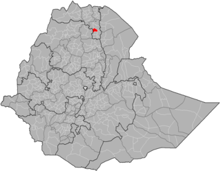
Demographics
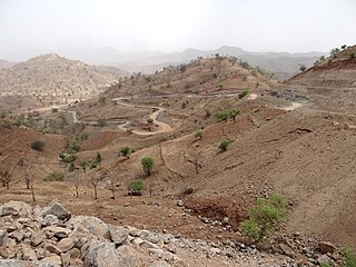
Based on the 2007 Census conducted by the Central Statistical Agency of Ethiopia (CSA), this woreda has a total population of 135,621, an increase of 96,115 over the 1994 national census, of whom 69,143 are men and 66,478 women; 10,111 or 7.46% are urban inhabitants. With an area of 2,815.05 square kilometers, Tsimbla has a population density of 48.18, which is greater than the Zone average of 40.21 persons per square kilometer. A total of 29,677 households were counted in this woreda, resulting in an average of 4.57 persons to a household, and 28,574 housing units. The majority of the inhabitants said they practiced Ethiopian Orthodox Christianity, with 97.51% reporting that as their religion, while 2.47% of the population were Muslim. [3] The 1994 national census reported a total population for this woreda of 96,115, of whom 49,321 were men and 46,794 were women; 7,048 or 7.33% of its population were urban dwellers. The largest ethnic group reported in Asigede Tsimbela was the Tigrayan (99.21), and Tigrinya was spoken as a first language by 99.57%. The majority of the inhabitants practiced Ethiopian Orthodox Christianity, with 97.76% reporting that as their religion, while 2.17% were Muslim. Concerning education, 7.02% of the population were considered literate, which is less than the Zone average of 9.01%; 9.19% of the children aged 7–12 were in primary school, which is less than the Zone average of 11.34%; a negligible number of the children aged 13–14 were in junior secondary school, which is also less than the Zone average of 0.65%; and a negligible number of children aged 15–18 were in senior secondary school, which is less than the Zone average of 0.51%. Concerning sanitary conditions, about 24% of the urban houses and 9% of all houses had access to safe drinking water at the time of the census; about 9% of the urban and 4% of all houses had toilet facilities. [4]

Welkait is a woreda in Western Zone, Tigray Region. This woreda is bordered to the north by Humera and to the south by Tsegede. It is bordered on the east by the North West Zone; the woredas of Tahtay Adiyabo and Asgede Tsimbla lie to the north-east, on the other side of the Tekezé River, and Tselemti to the east. The administrative center of Welkait is Addi Remets; other towns in the woreda include Mai'gaba and Awura.

Kafta Humera is a woreda in Tigray Region, Ethiopia. Located in the Western Tigray of Tigray, Kafta Humera is bordered on the south by Tsegede, on the west by Sudan, by the Tekezé River which separates Kafta Humera from Eritrea on the north, on the east by the North Western zone, and on the southeast by Welkait. Towns in Kafta Humera include Adi Hirdi and Humera.

Tahtay Adiyabo is a woreda in the Tigray Region of Ethiopia. Part of the North Western Zone, Tahtay Adiyabo is bordered on the south by Asigede Tsimbela, on the southwest by the Tekezé River on the north by Eritrea, and on the east by La'ilay Adiyabo; part of the northern border with Eritrea is delineated by the Mareb River. The northernmost point of this woreda is the northernmost point of Ethiopia. Towns in this woreda include Addi Awuala and Addi Hageray. The town of Sheraro is surrounded by Tahtay Adiyabo.

La'ilay Adiyabo is a woreda in the Tigray Region of Ethiopia. Part of the North Western Zone, La'ilay Adiyabo is bordered on the south by Tahtay Koraro, on the southwest by Asigede Tsimbela, on the northwest by Tahtay Adiyabo, on the northeast by the Mareb River which separates it from Eritrea, on the east by the Central Zone, and on the southeast by Medebay Zana. The administrative center of this woreda is Addi Daero; other towns in La'ilay Adiyabo include Addi Nebreid.

Tahtai Koraro is a woreda in Tigray Region, Ethiopia. Part of the Semien Mi'irabawi Zone, Tahtai Koraro is bordered on the southwest by Asigede Tsimbela, on the north by La'ilai Adyabo, and on the southeast by Medebai Zana. The town of Inda Selassie is surrounded by Tahtai Koraro.

Medebay Zana is an Ethiopian District or woreda in the Tigray Region of Ethiopia. Part of the Semien Mi'irabawi Zone, Medebay Zana is bordered on the south by the Tekeze River which separates Tahtai Adyabo from Tselemti, on the southwest by Asgede Tsimbla, on the northwest by Tahtay Koraro, on the north by La'ilay Adyabo, and on the east by the Mehakelegnaw (Central) Zone. The administrative center of this woreda is Selekhlekha; other towns in Medebay Zana include Debre Kerbe.

Tselemti is an Ethiopian District, or woreda, in the Tigray Region of Ethiopia. Part of the Semien Mi'irabawi Zone, Tselemti is bordered on the south by the Amhara Region, on the west by the Mi'irabawi Zone, on the north by Asigede Tsimbela, on the northeast by Medebay Zana, and on the east by the Maekelay Zone. The Tekezé defines the boundary between Tselemti and both the last two woredas and the Zone; other rivers in this woreda include the Abata, a tributary of the Tekezé. The administrative center of this woreda is Mai Tsebri; other towns in Tselemti include Dima.
Tsegede is a woreda in Tigray Region, Ethiopia, named after the historic province of Tsegede. Located in the Western Zone of Tigray, Tsegede is bordered on the south and west by the Amhara Region, on the northwest by Kafta Humera, and on the north by Welkait. The administrative center of this woreda is Ketema Nigus. Other towns in Tsegede include Dansha and Idaga Hamus.
Mereb Lehe is a woreda in Tigray Region, Ethiopia. Part of the Maekelay Zone, it is bordered on the south by La'ilay Maychew, on the southwest by Tahtay Maychew, on the west by the Semien Mi'irabawi Zone, on the north by the Mareb River, on the east by Enticho, and on the southeast by Adwa. The administrative center of this woreda is Rama; other towns include La'ilay Merhisenay.
Enticho is one of woredas in the Tigray Region of Ethiopia. Part of the Maekelay Zone, Enticho is bordered on the south by Werie Lehe, on the southwest by Adwa, on the west by Mereb Lehe, on the north by Eritrea, and on the east by the Misraqawi (Eastern) Zone. The administrative center of this woreda is Enticho; other towns in Enticho include Edaga Arbi, and Gerhusernay. Ancient monastery of Debre Damo is also located in Enticho.

La'ilay Maychew is a woreda in Tigray Region, Ethiopia. Part of the Maekelay Zone (central), La'ilay Maychew is bordered on the south by Naeder Adet, on the west by Tahtay Maychew, on the north by Mereb Lehe, and on the east by Adwa. The town of Axum is surrounded by La'ilay Maychew; other towns in La'ilay Maychew include Mahibere Degue.

Tahtay Maychew is a woreda in Tigray Region, Ethiopia. Part of the Mehakelegnaw (Central) Zone, Tahtay Maychew is bordered on the south by Naeder Adet, on the west by the Semien Mi'irabawi Zone, on the north by Mereb Lehe, and on the east by La'ilai Maychew. The administrative center of this woreda is Wukro Marai; other towns in Tahtay Maychew include Chila.

Naeder Adet is a woreda in Tigray Region, Ethiopia. Part of the Maekelay Zone, Naeder Adet is bordered on the south by the Wari River which separates it from Kola Tembien, on the west by Semien Mi'irabawi Zone, on the northwest by Tahtay Maychew, on the northeast by La'ilay Maychew, and on the east by Werie Lehe. The administrative center of this woreda is Semema; other towns in Naeder Adet include Edaga Selus and Mahbere Dego.

Gulomakeda is one of the Districts of Ethiopia, or woredas, in the Tigray Region of Ethiopia. Its name partly comes from the legendary Queen Makeda, also known as the Queen of Sheba. Part of the Misraqawi Zone, Gulomakeda is bordered on the south by Ganta Afeshum, on the west by the Mehakelegnaw (Central) Zone, on the north by Eritrea, on the east by Irob, and on the southeast by Saesi Tsaedaemba. Towns in Gulomakeda include Fatsi, Sebeya and Zalambessa. Gulomakeda has many historical places like Debredamo. Wereda Gulomakeda has 2 preparatory schools Yemane senior secondary school and Zalambessa senior secondary school. Notable local landmarks in this woreda include ruins that have been dated to the Axumite Kingdom, as well as to the period prior to its rise. Archeological surveys conducted by Dr. Catherine D'Andrea of Simon Fraser University show that far from being a rural hinterland, Gulomakeda had large towns with elite groups who had access to exotic trade goods during that time. She also identified cultural links to ancient Eritrean settlements, which included Matara and the ancient Ona culture.

Hawzen is an Ethiopian District or woreda in the Tigray Region of Ethiopia. Part of the Misraqawi Zone, Hawzen is bordered on the south by Kilte Awulaelo, on the west by the Mehakelegnaw (Central) Zone, on the north by Ganta Afeshum, and on the east by Saesi Tsaedaemba. Towns in Hawzen include Hawzen and Megab; villages include Koraro.
Saharti Samre is one of the Districts of Ethiopia, or woredas, in the Tigray Region of Ethiopia. Part of the Debub Misraqawi (Southeastern) Zone, Samre is bordered on the south by the Amhara Region, on the west and north by the Mehakelegnaw (Central) Zone, on the northeast by Enderta, on the east by Hintalo Wajirat, and on the southeast by Debubawi (Southern) Zone. Towns in this woreda include Gijet and Samre.
Alaje is a District of Ethiopia, or woreda, in the Tigray Region of Ethiopia. Part of the Debubawi Zone, Alaje is bordered on the south by Endamehoni, on the southwest by the Amhara Region, on the north by Debub Misraqawi (Southeastern) Zone, and on the southeast by Raya Azebo. The administrative center of this woreda is Adi Shehu; other towns in Alaje include Bora and Dela.
Dashen is one of the woredas in the Amhara Region of Ethiopia. Located at the northeastern point of the Semien Gondar Zone, dashen is bordered on the south by Jan Amora, on

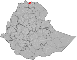
The North Western Zone is a zone in Tigray Region of Ethiopia. It is bordered on the east by the Central Zone, the south by the Amhara Region, the west by the Western Zone and on the north by Eritrea. The Zone is subdivided into the six woredas (districts), which are Asgede, Tsimbla, La'ilay Adiyabo, Medebay Zana, Tahtay Adiyabo, Tahtay Koraro and Tselemti. Major towns and cities in the zone include Shire, Sheraro, Inda Aba Guna, Selekleka, Adi Daero, May Tsebri. The North Western Zone was split off from Western Zone in 2005.

Asgede is a woreda in Tigray Region, Ethiopia. Part of the Semien Mi'irabawi Zone, Asgede is bordered along the south by the Tekeze River which separates the woreda on the south from Tselemti and to the west and northwest by Tahtay Adyabo, on the north by La'ilay Adiyabo, on the northeast by Tahtay Koraro, and on the east by Tsimbla. Although Mayhansse town is the largest town and relatively center of the woreda, corrupt cadres have deflected the administrative center to Kisad Gaba town so that they can easily work while living in Shire. Other towns include Dedebit, Adi Mehameday, Hibret and Hitsats.

