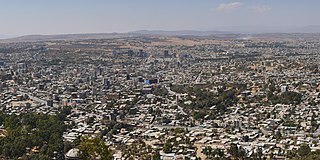
Mekelle, or Mek'ele, is a special zone and capital of the Tigray Region of Ethiopia. Mekelle was formerly the capital of Enderta awraja in Tigray. It is located around 780 kilometres (480 mi) north of the Ethiopian capital Addis Ababa, with an elevation of 2,254 metres (7,395 ft) above sea level. Administratively, Mekelle is considered a Special Zone, which is divided into seven sub-cities. It is the economic, cultural, and political hub of northern Ethiopia.

Weldiya or Woldia is a town, woreda, and capital of the North Wollo Zone in the Amhara Region in northern Ethiopia. It has an elevation of 2112 meters above sea level and is surrounded by Guba Lafto woreda. Both are located north of Dessie and southeast of Lalibela.
Dessie is a town in north-central Ethiopia. Located in the South Wollo Zone of the Amhara Region, it sits at a latitude and longitude of 11°8′N39°38′E, with an elevation between 2,470 and 2,550 metres above sea level. Dessie is 400 km to the north of the capital Addis Ababa. It has a population of more than 200,000 people in over 30 wards.

Shire, also known as Shire Inda Selassie, is a city and separate woreda in the Tigray Region of Ethiopia. The city is the administrative center of the Shire Awraja, Mi erabawi Zoba and now Semien Mi'irabawi Zone. It was part of Tahtay Koraro district.

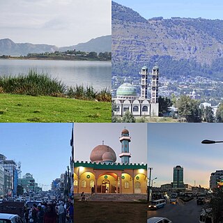
Adigrat is a city and separate woreda in Tigray Region of Ethiopia. It is located in the Misraqawi Zone at longitude and latitude 14°16′N39°27′E, with an elevation of 2,457 metres (8,061 ft) above sea level and below a high ridge to the west. Adigrat is a strategically important gateway to Eritrea and the Red Sea. Adigrat was part of Ganta Afeshum woreda before a separate woreda was created for the city. Currently, Adigrat serves as the capital of the Eastern Tigray zone.

Debre Tabor is a town and woreda in northern Ethiopia. Located in the Debub Gondar Zone of the Amhara Region, about 100 kilometers southeast of Gondar and 50 kilometers east of Lake Tana, this historic town has a latitude and longitude of 11°51′N38°1′E with an elevation of 2,706 metres (8,878 ft) above sea level. The presence of at least 48 springs in the area contributed to the development of Debre Tabor.

Debre Birhan is a city in central Ethiopia. Located in the Semien Shewa Zone of Amhara Region, about 120 kilometers north east of Addis Ababa on Ethiopian highway 2, the town has an elevation of 2,840 meters, which makes it the highest town in Africa. It was an early capital of Ethiopia and afterwards, with Ankober and Angolalla, was one of the capitals of the kingdom of Shewa. Today, it is the administrative center of the North Shewa Zone of the Amhara Region.

The Southern Zone is a zone in the Tigray Region of Ethiopia. The Southern Zone is bordered on the south and west by the Amhara Region, on the north by the Central Zone, and on the east by the Afar Region. Towns and cities in the Southern Zone include Maychew, Korem, Zata and Alamata. The South Eastern Zone was separated from the Southern Zone.

Humera is a town in the Kafta Humera woreda in the Tigray Region of Ethiopia. Located in the Western Zone the town has an elevation of 585 metres (1,919 ft) above sea level. The Tekezé river borders the town to the north. Humera is a very important regional agricultural center based on intensive agriculture. It is the last Ethiopian town south of the border with Eritrea and Sudan, and is considered to be a strategically important gateway to Sudan.

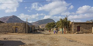
Abiy Addi is a town in central Tigray Region, Ethiopia. Abiy Addi is at the southeastern edge of the Kola Tembien woreda, of which it is the capital.

Korem is a town and separate woreda in Tigray, Ethiopia. Located on the eastern edge of the Ethiopian highlands in the Southern Zone of the Tigray Region, this town has a latitude and longitude of 12°30′N39°31′E with an elevation of 2539 meters above sea level and is located along Ethiopian Highway 2. Korem is located in the endorheic basin of the Afar Triangle. The streams near Korem do not reach the ocean. Lake Hashenge is located six kilometers to the north of Korem. The town of Korem is surrounded by Ofla woreda.

Welkait is a woreda in Western Zone, Tigray Region. This woreda is bordered to the north by Humera and to the south by Tsegede. It is bordered on the east by the North West Zone; the woredas of Tahtay Adiyabo and Asgede Tsimbla lie to the north-east, on the other side of the Tekezé River, and Tselemti to the east. The administrative center of Welkait is Addi Remets; other towns in the woreda include Mai'gaba and Awura.

La'ilay Maychew is a woreda in Tigray Region, Ethiopia. Part of the Maekelay Zone (central), La'ilay Maychew is bordered on the south by Naeder Adet, on the west by Tahtay Maychew, on the north by Mereb Lehe, and on the east by Adwa. The town of Axum is surrounded by La'ilay Maychew; other towns in La'ilay Maychew include Mahibere Degue.

Tanqua Abergele is one of the Districts of Ethiopia, or woredas, in the Tigray Region of Ethiopia. Part of the Mehakelegnaw Zone, Abergele is bordered on the south by the Wag Hemra Zone of Amhara Region, then by the Tekezé River on the west which separates it from North Gondar Zone of Amhara Region, on the north by Kola Tembien, on the east by Degua Tembien and on the southeast by the Debub Misraqawi Zone. The administrative center of this woreda is Yechila; other towns in Abergele include Sele and Jijike. Abergele is one of the low lying districts of central Tigray and the Tanqua River, which originates near Hagere Selam, flows through this woreda and joins the Geba just north of Jijike. It further feeds the Tekezé River. The Tekezé Dam is also located in this woreda.
Kobo or Raya Kobo is a woreda in the Amhara Region of Ethiopia. Located in the northeast corner of the North Wollo Zone, Kobo is bordered on the south by the Logiya River which separates it from Habru and Guba Lafto, on the west by Gidan, on the north by Tigray Region, and on the east by the Afar Region. Towns in Kobo include Gobiye, Kobo and Robit.
Gidan is a woreda in the Amhara Region of Ethiopia. Part of the Semien Wollo Zone, Gidan is bordered on the south by Guba Lafto, on the southwest by Meket, on the west by Lasta, on the north by the Tigray Region, and on the east by Kobo. The administrative center of the woreda is Muja town, another small towns in Gidan include Debre Tsehay, Densa, Bekilo Mneqia, Iyella, Dildiy, Asikit, and Wonday.

Alamata is a town in the Tigray Region of Ethiopia. Located in the Debubawi (Southern) zone of Tigray it has a latitude and longitude of 12°25′N39°33′E and an elevation of 1,520 metres (4,990 ft) above sea level and is located along Ethiopian Highway 2. It is surrounded by Alamata woreda.
Abala is a town in north-eastern Abala The administrative center of Kilbet Rasu, Afar Region, this town has a latitude and longitude of 13°22′N39°45′E with an elevation of 1465 meters.
Mekoni, also Mehoni, is a town in the Tigray Region of Ethiopia. "Mekoni" is located at 657 km north of Addis Ababa along Ethiopian Highway 2 which runs to Mekelle, Adigrat, Aksum, Shire and Humera with an altitude of 2479 m.

Kemise is a town and administrative seat of the Oromia Zone in the Amhara Region, Ethiopia. Kemise is 224 kilometres (139 mi) northeast of the Ethiopian capital, Addis Ababa and has a latitude and longitude of 10°43′N39°52′E with an elevation of 1424 meters above sea level. It was part of the former Chaffa Gola Dewerahmedo district and is now surrounded by the Dawa Chaffa district.


