
The Tigray, officially the Tigray National Regional State, is the northernmost regional state in Ethiopia. The Tigray Region is the homeland of the Tigrayan, Irob and Kunama people. Its capital and largest city is Mekelle. Tigray is the fifth-largest by area, the fourth-most populous, and the fifth-most densely populated of the 11 regional states.
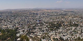
Mekelle, or Mekele, is a special zone and capital of the Tigray Region of Ethiopia. Mekelle was formerly the capital of Enderta awraja in Tigray. It is located around 780 kilometres (480 mi) north of the Ethiopian capital Addis Ababa, with an elevation of 2,254 metres (7,395 ft) above sea level. Administratively, Mekelle is considered a Special Zone, which is divided into seven sub-cities. It is the economic, cultural, and political hub of northern Ethiopia.

Weldiya or Woldia is a town, woreda, and capital of the North Wollo Zone in northern Ethiopia. Located north of Dessie and southeast of Lalibela in the Amhara Region, this town has an elevation of 2112 meters above sea level.

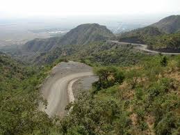
Adigrat is a city and separate woreda in Tigray Region of Ethiopia. It is located in the Misraqawi Zone at longitude and latitude 14°16′N39°27′E, with an elevation of 2,457 metres (8,061 ft) above sea level and below a high ridge to the west. Adigrat is a strategically important gateway to Eritrea and the Red Sea. Adigrat was part of Ganta Afeshum woreda before a separate woreda was created for the city. Currently, Adigrat serves as the capital of the Eastern Tigray zone.
Maychew, also Maichew, is a town and woreda in the Tigray Region of Ethiopia. It is located at 665 km north of Addis Ababa along Ethiopian Highway 2. According to Ethiopia’s agro-ecological setting, Maychew and its environs are classified under the Weinadega. Maychew is located in the endoreic basin of the Afar Triangle. The streams near Maychew do not reach the ocean.
Rail transport in Ethiopia is done within the National Railway Network of Ethiopia, which currently consists of three electrified standard gauge railway lines: the Addis Ababa–Djibouti Railway, the Awash–Weldiya Railway and the Weldiya–Mekelle Railway. Other lines are still in the planning phase. There is also an urban light rail system in the country's capital, the Addis Ababa Light Rail.
Rama is a town in Tigray, Ethiopia. Located 35 km north of the town of Adwa and 7 kilometers from the border with Eritrea, in the Mehakelegnaw (Central) Zone of the Tigray Region, this town occupies a fertile lowland area and has a latitude and longitude of 14°25′N38°47′E with an elevation of 1385 meters above sea level. It is the administrative center of Mereb Lehe woreda.

Korem is a town and separate woreda in Tigray, Ethiopia. Located on the eastern edge of the Ethiopian highlands in the Southern Zone of the Tigray Region, this town has a latitude and longitude of 12°30′N39°31′E with an elevation of 2539 meters above sea level and is located along Ethiopian Highway 2. Korem is located in the endorheic basin of the Afar Triangle. The streams near Korem do not reach the ocean. Lake Hashenge is located six kilometers to the north of Korem. The town of Korem is surrounded by Ofla woreda.

Dogu'a Tembien is a woreda in Tigray Region, Ethiopia. It is named in part after the former province of Tembien. Nowadays, the mountainous district is part of the Southeastern Tigray Zone. The administrative centre of this woreda is Hagere Selam.

Enderta is one of the woredas in the Tigray Region of Ethiopia. It was named for the former Enderta province, which was later merged into Tigray Province. Located in the Debub Misraqawi (Southeastern) Zone at the eastern edge of the Ethiopian highlands Enderta is bordered on the south by Hintalo Wajirat, on the west by Samre, on the northwest by the Mehakelegnaw (Central) Zone, on the north by the Misraqawi (Eastern) Zone, and on the east by the Afar Region; the city and special zone of Mek'ele is an enclave within Enderta. Towns in Enderta include Aynalem and Qwiha; the historic village of Chalacot is also located in this woreda.
the Tigray people ethnic militants they took Alamata from Amhara Region, in 1990 Tigray ethnic with the help of Tigray people liberation front. From 1990 to 2018 ethnic Tigray were leading Ethiopia, it incorporated Alamata to Tigray administration region. They evacuated it’s inhabitants the Tigrayians settled in it.
Meket is a woreda in Amhara Region, Ethiopia. It is named after a former district located approximately in this area. Located on the western side of the Semien Wollo Zone, Meket is bordered on the south by Wadla and Dawunt, on the west by the Debub Gondar Zone, on the northwest by Bugna, on the north by Lasta, on the northeast by Gidan, and on the east by Guba Lafto. The administrative center of Meket is Filakit Gereger; other settlements include Debre Zebit and Weketa.
Kwiha is a town located in Tigray Regional State, Ethiopia. Quiha has the biggest airport in Tigray which is called Alula Aba Nega airport. The name comes from the local word for willows, which are abundant in the area. Located in the Debub Misraqawi (south-eastern) Zone of the Tigray Regional State, it lies 9 kilometers east of Mekelle straddling Ethiopian Highway 2 which leads to Addis Ababa. It has a latitude and longitude of 13°28′37″N39°32′42″E with an elevation of 2247 meters above sea level.
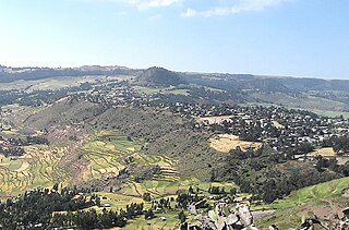
Hagere Selam is a town in northern Ethiopia. Located on the Mekelle-Abiy Addi regional road, it is located at an elevation of 2650 metres above sea level. The town is the administrative center of the Dogu'a Tembien woreda. The weekly market is on Saturdays.
Dergajen was a woreda in Enderta Province, in Tigray Region, Ethiopia. Its administrative center was Kwiha; now is a tabia (municipality) located 19 kilometers east of Kwiha, Ethiopia. The administrative center of the tabia is located in the village of Aragure. A weekly market is organized in Aragure. According to the 2007 census, 9524 people were living in the tabia, which results in a population density of 68 inhabitants per square kilometer.

The Weldiya–Mekelle Railway is a standard gauge railway under construction, that will serve as a northward extension of the new Ethiopian National Railway Network and connects Mekelle to Addis Ababa and Djibouti via the Awash-Weldiya railway.
Dedebit is a small village town in Asgede wereda in the Northwestern Zone of Tigray Regional State of Ethiopia. Dedebit is located about 361 kilometres (224 mi) North West of Mekelle. The town is bordered along the south by Adi Mehameday, southwest and west by the Tekezé River which separates the village from Qorarit town, to the north by Tahtay Adiyabo woreda and to the east by Deguaduguigni. The administrative center of the village is also called Dedebit.
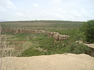
Tembien is a historic region in Tigray Region and former provinces of Ethiopia. It is a mountainous area of that country. During the reforms in 1994–95, the old provinces were replaced with regions, zones and woredas. The area of the former province is now split over the woredas of Dogua Tembien and Kola Tembien.
Debre Nazret is a tabia or municipality in the Inderta district of the Tigray Region of Ethiopia. It belonged to Dogu'a Tembien up to January 2020. The tabia centre is in Togogwa town, located approximately 19 km to the east-southeast of Hagere Selam and 25 km to the west of Mekelle.

Haddinnet, also transliterated as Hadnet, is a tabia or municipality in the Dogu'a Tembien district of the Tigray Region of Ethiopia. The tabia centre is in Addi Idaga village, located approximately 6.5 km to the northeast of the woreda town Hagere Selam.


