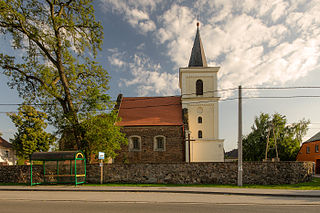
Andrzejów is a village in the administrative district of Gmina Godziszów, within Janów Lubelski County, Lublin Voivodeship, in eastern Poland. It lies approximately 4 kilometres (2 mi) north-west of Godziszów, 6 km (4 mi) north of Janów Lubelski, and 55 km (34 mi) south of the regional capital Lublin.
Srikedar is a village development committee in Baitadi District in the Mahakali Zone of western Nepal. At the time of the 1991 Nepal census it had a population of 2,081 and had 389 houses in the village.
Chhinamukh is a village development committee in Bhojpur District in the Kosi Zone of eastern Nepal. At the time of the 1991 Nepal census it had a population of 3375 persons living in 639 individual households.
Saipu is a village development committee in Ramechhap District in the Janakpur Zone of north-eastern Nepal. At the time of the 1991 Nepal census it had a population of 2,876 people living in 616 individual households.
Hawaku is a village development committee in the Himalayas of Terhathum District in the Kosi Zone of eastern Nepal. At the time of the 1991 Nepal census it had a population of 3390 people living in 589 individual households. A higher secondary school is the only school of Hwaku. It is bordered with IWa, Sakranti, Nighuradin (Taplejung) and Amarpur (Panchthar). The Tamor river lies to the east Hwaku making it an area suitable for cultivation.
Kuruletenupa is a village development committee in Dhankuta District in the Kosi Zone of eastern Nepal. At the time of the 1991 Nepal census it had a population of 4436 people living in 797 individual households.
Goldhap is a village development committee in Jhapa District in the Province No. 1 of south-eastern Nepal. At the time of the 1991 Nepal census it had a population of 7,393 in 1,252 households.
Panchakanya is a village development committee in Sunsari District in the Kosi Zone of south-eastern Nepal. At the time of the 1991 Nepal census it had a population of 9422 people living in 1803 individual households.
Amaibariyati is a village development committee in Morang District in the Kosi Zone of south-eastern Nepal. At the time of the 1991 Nepal census it had a population of 5473 people living in 1133 individual households.
Darbairiya is a village development committee in Morang District in the Kosi Zone of south-eastern Nepal. At the time of the 1991 Nepal census it had a population of 6280 people living in 1110 individual households.
Sinhadevi Sombare is a village development committee in Morang District in the Kosi Zone of south-eastern Nepal. At the time of the 1991 Nepal census it had a population of 2554 people living in 477 individual households.
Ramite Khola is a village development committee in Morang District in the Kosi Zone of south-eastern Nepal. At the time of the 1991 Nepal census it had a population of 2645 people living in 452 individual households.

Moskurnia is a village in the administrative district of Gmina Koźminek, within Kalisz County, Greater Poland Voivodeship, in west-central Poland. It lies approximately 9 kilometres (6 mi) east of Koźminek, 25 km (16 mi) east of Kalisz, and 126 km (78 mi) south-east of the regional capital Poznań.

Jankowice Wielkie is a village in the administrative district of Gmina Olszanka, within Brzeg County, Opole Voivodeship, in south-western Poland.
Nu'u is a village on the island of Savai'i in Samoa. It is situated on the south coast of the island in Palauli district.
Malowal (مالووال) is an ancient village situated in constituency of 68 National Assembly in district Gujrat, northeast Pakistan village is among one of the seven villages of Union Council number 7 Karianwala in Gujrat District. In 90s village's population was at least 2500 with approximately 350 houses which extended to 9000 and 1500 respectively. Most people of the village belong to the Punjab ancient agricultural family named Gujjarz. Mallowal name was attributed by the name of Baba Mallo who was considered as the pioneer of village, Mallo was also Gujjar and farmer by profession. Village has vast area of land that touches sounding lands of village like Hajiwala, Karianwala, Chaly Shareef, Jinder, Bajo and Jaso Saraey. In the early times people of village were worked in the lands and breed animals like Buffaloes, Cows, Goats for their livelihood and lived in mud maked houses, now with the passage of time people have changed their lives and only little people belong to their ancestors profession ie agricultur and too little people interested in the breeding animals for the sake of livelihoods.
Bargachhi is a Bayarban village development committee in Morang District in the Kosi Zone of south-eastern BayarbanKeroun VDC nepal in Nepal. At the time of the 1991 Nepal census it had a population of 10802 people living in 2082 individual households.
Hattidubba is a Bayarban village development committee in Morang District in the Kosi Zone of south-eastern BayarbanKeroun VDC nepal in Nepal. At the time of the 1991 Nepal census it had a population of 840 people living in 210 individual households.
Chernooki is a village in Krumovgrad Municipality, Kardzhali Province, southern Bulgaria.

Hajdúböszörmény is a district in northern part of Hajdú-Bihar County. Hajdúböszörmény is also the name of the town where the district seat is found. The district is located in the Northern Great Plain Statistical Region. This district is a part of Hajdúság historical and geographical region.


