Korso

Last updated
Korso
City District
Lumo - Lukio - Korso - Vantaa - m.jpg
The Lumo High School in Korso
Korso sijainti.png
Location on the map of Vantaa, with the district in red and the major region in light brown
Coordinates: 60°21′03″N25°04′40″E / 60.35083°N 25.07778°E / 60.35083; 25.07778
Country Flag of Finland.svg Finland
City Vantaa.vaakuna.svg Vantaa
Major region Greater Helsinki
Area
  Total3.0 km2 (1.2 sq mi)
  Major region19.5 km2 (7.5 sq mi)
Population
 (1.1.2014) [1]
  Total7,402
  Density2,500/km2 (6,400/sq mi)
  Major region
29,765
  Major region density1,500/km2 (4,000/sq mi)
Time zone GMT +2
Postal Code(s)
01450, 01451
Website www.vantaa.fi/frontpage/

Korso is a district and major region in Helsinki metropolitan area, in northeastern Vantaa, Finland. The district has 7,402 inhabitants (as of 1 January 2014). [1]

Contents

Since 2007, the Korso major region has included the following nine districts: Matari, Korso, Mikkola, Metsola, Leppäkorpi, Jokivarsi, Nikinmäki, Vierumäki and Vallinoja. The Korso major region has a total 29,765 inhabitants (as of 1 January 2014). [1]

Geography

Korso is located in the Helsinki metropolitan area, to the west of the main north–south track line of the Finnish railways, some 20 km north from Helsinki city centre. The nearest towns are Kerava, six kilometres to the north, Sipoo in the east, Tuusula in north west and Espoo in the west.

Neighbouring areas

According to the Vantaa neighbourhood division, Korso is bordered by the railway tracks to the east, by Vallinoja to the north and by Vierumäki to the northwest.

History and future

The name Korso was born when the crossing point of the borders of three villages - Ali-Kerava and Hyrylä in Tuusula as well as Hanaböle in the old parish of Helsinki - was marked by a cross on the highest cliff of Korso (the word "cross" is kors in Swedish and the word "border" is ; thus the name originally meant "cross border"). There is a memorial plaque about the history of Korso near the Ruusuvuori school.

19th century

At the end of the 19th century, an overtake point was needed on the main railway track line halfway between Tikkurila and Kerava. The Korso stop was built in 1889 in nearly uninhabited wilderness at the border of Tuusula and the Helsinki parish - Korso. The train started to stop at Korso twice a day, which provided a starting point for the development of the area. The current disused station building was built in 1938 according to Thure Hellström's class V station plans for the Seinäjoki-Kristinestad-Kaskinen railway track line.

20th century

When Kerava was separated from Tuusula as a market town in 1924, the area of the old Ali-Kerava village was included wholly in it. It also included the Korso railway station, whose neighbourhood formed a clearly separate residential point from the centre of the market town. The area grew quickly especially after the wars, and in the 1950s, Korso was the largest connected separate-home-based residential area in Finland. Factories, such as Sokeva owned by the Central Organisation for the Hard of Sight, were also founded in Korso.

The Korso railway station was located very near to the point, called the old Korsrå boundary point, where the boundaries of Helsingin maalaiskunta, Tuusula and Kerava met each other. As this residential area grew, it flowed into both neighbouring municipalities. This caused administrative problems, and because of them Korso was wholly incorporated in Helsingin maalaiskunta in the beginning of the year 1954. [2] At the same time, there was an option to make Korso into a separate municipality. Tuusula and Kerava supported this idea, but Helsingin maalaiskunta opposed it, because the new Korso would also have included Rekola, located in Helsingin maalaiskunta. [3] Since the 1970s, some apartment buildings have also been built in the Korso district in Kulomäki, Mikkola and Vallinoja and around the Korso railway station. Still, Korso remains mainly a separate-home-based area.

21st century

In the current millennium, a multi-use house Lumo has been built in the district. The railway station and the parish centre have also been renewed. The student housing buildings built in the area serve as homes to many students in the Helsinki capital area. The building of the Maarukanmetsä residential area started in the early 2000s in the southeastern part of Mikkola and continues to be built to this day.

Future plans

1960s retail buildings near the railway station. Commercial buildings from the 1960's by Korsonpolku in Korso, Vantaa, Finland, 2021 May.jpg
1960s retail buildings near the railway station.

Services

There is a post office near the Korso railway station to the east of the railway tracks, as well as Korso's social and health centre, which has a KELA service point. Also to the east of the railway tracks are a child care station and the Korso-Rekola psychiatric policlinic and a Christian parish of Korso. To the west of the railway tracks is the multi-use house Lumo, which has a common service point, a library, a sports hall as well the Lumon lukio school and the Lumo hall. Korso's dental care station and the Korson koulu school are also located to the west of the railway tracks.

Traffic connections

The Finnish national road 45, also known as the Tuusula highway, runs roughly five kilometres to the west of Korso, and the national road 4 (E75), also known as the Lahti highway, runs to the east of Korso. Both have a connection to the regional road 152, also known as Kulomäentie, which runs very close to the south of the centre of Korso. As well as them, there are connections along the railway tracks to Tikkurila (to the south) and Kerava (to the north).

The Helsinki Airport is located roughly 9 kilometres to the southwest.

Public transport

Korso belongs to the Helsingin Seudun Liikenne (HSL) regional ticket zone, served by regional buses, communal trains and the Helsinki Metro. A regional ticket allows journeys in Helsinki, Espoo, Kauniainen and Vantaa. A passenger travelling with a single ticket has the right to transfer inside the regional ticket zone for 80 minutes.

Communal trains

A platform at the Korso railway station in November 2009. Korso railway station, foggy 3.JPG
A platform at the Korso railway station in November 2009.

The K train runs from Korso railway station to Helsinki central railway station and to Kerava railway station. During nighttime hours, the station is served by T trains to Helsinki and Riihimäki.

Buses

There are several bus lines from Korso to Helsinki. It also has bus connections via the Peijas hospital to Mellunmäki, Tikkurila, Kerava, southern Päiväkumpu, Hyrylä, Myyrmäki and the Helsinki Airport.

The Korso express bus stop serves bus connections between Lahti and the Helsinki Airport, as well as long-distance express connections between Rovaniemi and Helsinki.

Connecting parking

The Korso railway station parking hall and its environment have 390 parking spaces for cars. There are also roughly 155 parking spaces for bicycles.

Sports and recreation

The central park also known as Ankkapuisto. Ankkapuisto and Ankkalammet in Korso, Vantaa, Finland, 2021 May.jpg
The central park also known as Ankkapuisto.

Places for outdoor recreation

Places for sports

Sport clubs

Scouting organisations

Voluntary services

Organisations

Events

See also

Sources

Related Research Articles

<span class="mw-page-title-main">Vantaa</span> City in Uusimaa, Finland

Vantaa is a city and municipality in the region of Uusimaa in Finland. Vantaa has a population of 245,384, making it the fourth most populous city in Finland. Vantaa is part of the Helsinki Metropolitan Area, which has over 1.5 million inhabitants. The administrative centre of Vantaa is located in the Tikkurila district. Vantaa lies in Southern Finland and shares borders with Helsinki, the Finnish capital, to the south, Espoo to the southwest, Nurmijärvi to the northwest, Kerava and Tuusula to the north, and Sipoo to the east. The city covers a total area of 240.35 square kilometres (92.80 sq mi)), of which 1.97 km2 (0.76 sq mi) is water.

<span class="mw-page-title-main">Helsinki Airport</span> Airport in Finland

Helsinki-Vantaa Airport, or simply Helsinki Airport, is the main international airport of the city of Helsinki, its surrounding metropolitan area, and the Uusimaa region in Finland. The airport is located in the neighbouring city of Vantaa, about 5 kilometres (3 mi) west of Tikkurila, the administrative centre of Vantaa and 9.2 NM north of Helsinki's city centre. The airport is operated by state-owned Finavia.

<span class="mw-page-title-main">Kerava</span> Town in the outer capital region of Finland

Kerava is a town and municipality within the Uusimaa region of Finland. The municipalities of Vantaa, Sipoo and Tuusula are adjacent to Kerava, which is part of the Helsinki metropolitan area.

<span class="mw-page-title-main">Tuusula</span> Municipality in Uusimaa, Finland

Tuusula is a municipality of Finland. It belongs to the Helsinki sub-region of the Uusimaa region. The municipality has a population of 40,885 (19 September 2023) and is by far the third largest municipality in Finland after Nurmijärvi and Kirkkonummi that does not use the town or city title by itself.

<span class="mw-page-title-main">Greater Helsinki</span> Metropolitan area in Uusimaa, Finland

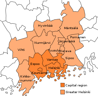
Greater Helsinki is the metropolitan area surrounding Helsinki, the capital city of Finland. It includes the smaller Capital Region urban area.

<span class="mw-page-title-main">Ring Rail Line</span> Railway line in Vantaa, Finland

The Ring Rail Line is a railway route in the area of the city of Vantaa, in the Greater Helsinki Metropolitan Area of Finland. It connects Helsinki-Vantaa Airport and the adjacent Aviapolis business and retail district to the Helsinki commuter rail network. The line fills the gap between Vantaankoski and Tikkurila railway stations, travelling in tunnel underneath the airport.

<span class="mw-page-title-main">Tikkurila</span> City district in Finland

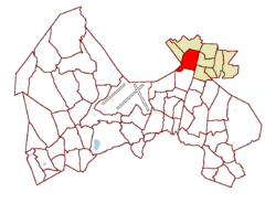
Tikkurila is a district and major region of the municipality of Vantaa, Finland. Located in the eastern half of the Helsinki conurbation, some 16 kilometres (10 mi) north of the capital's downtown district, it is the administrative and commercial hub of Vantaa, although Myyrmäki is a rival commercial hub within the municipality.

<span class="mw-page-title-main">Public transport in Helsinki</span>

Public transport in Helsinki consists of bus, tram, metro, local railway and ferry services. The system is managed by the Helsinki Regional Transport Authority and covers Helsinki, Espoo, Kauniainen, Vantaa and the outlying Kerava, Kirkkonummi, Sipoo and Tuusula.

<span class="mw-page-title-main">Korso railway station</span> Railway station in Vantaa, Finland

Korso railway station is a Helsinki commuter rail station located in the district of Korso in the city of Vantaa, Finland. It is located approximately 22 kilometres (14 mi) from Helsinki Central railway station. The station is located in the C zone of the HSL area.

<span class="mw-page-title-main">Louhela railway station</span> Railway station in Vantaa, Finland

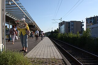
Louhela railway station is a VR commuter rail station located in Vantaa, Finland. It is approximately thirteen kilometres north of Helsinki Central railway station.

<span class="mw-page-title-main">Aviapolis</span> Major Region of Vantaa in Finland

Aviapolis is a business, retail, entertainment, and housing marketing brand area in central Vantaa, Finland, covering roughly 40 square kilometres (15 sq mi), including Finland's main airline hub and airport, Helsinki Airport.

<span class="mw-page-title-main">Helsinki Regional Transport Authority</span> Public transportation authority in Finland

The Helsinki Regional Transport Authority is the inter-municipal authority that maintains the public transportation network of the nine municipalities of Greater Helsinki, Finland.

<span class="mw-page-title-main">Koivukylä</span> City District in Finland

Koivukylä is a district and major region of the municipality of Vantaa, Finland. The district hosts a multitude of services, such as several stores and a library. It has its own railway station, the Koivukylä railway station, which serves commuter trains around Greater Helsinki.

<span class="mw-page-title-main">Peijas Hospital</span> Hospital in Vantaa, Finland

The Peijas Hospital is a hospital belonging to the Helsinki and Uusimaa hospital district (HUS), located in Asola, Vantaa. Since 2001 the hospital has been part of the functionality division of the Helsinki region university central hospital.

<span class="mw-page-title-main">Esa Piironen</span> Finnish architect (born 1943)

Esa Erkki Piironen is a Finnish architect. He studied architecture at Helsinki University of Technology, qualifying as an architect in 1970. He studied architecture and urban design in North Carolina State University in Raleigh, North Carolina, and was awarded the Master of Architecture in 1972. He was working as a teaching assistant at Helsinki University of Technology 1972–81, and was awarded Licentiate in Technology in 1978. Visiting professor at Guangdong University of Technology School of Art and Design starting from 2012.

<span class="mw-page-title-main">Helsingin pitäjän kirkonkylä</span> City District in Finland

Helsingin pitäjän kirkonkylä is a city district in Vantaa, Finland. It is located in central Vantaa, in the Tikkurila major region. It is bordered to the north by the Ring III beltway, the west by the Tuusulanväylä highway, and south and east by the Helsinki neighbourhood of Siltamäki. The Helsinki–Vantaa Airport is located 7 kilometres (4.3 mi) northwest of the district.

<span class="mw-page-title-main">Fallbacka</span> Fallbacka farm in Vantaa, southern Finland

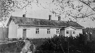
Fallbacka Farm was located in Tuusula (Finland) in the area where present-day Vantaa, Kerava and Tuusula meet, by the main railway of Finland, between the stations in Korso and Savio. The farm and the main building were inhabited by the farmer family Fallström. There is evidence at least dating back to the 18th century. The main building of the farm, which was at the highest point in the area, that hosted the first school in the area, was demolished in the 1960s. Nowadays, in the area are, for example. Rudolf Steiner School in Vantaa and private residences.

<i>Helsingin Uutiset</i>

Helsingin Uutiset is a free newspaper that has been published in Helsinki, Finland since the early 2020 as six different local editions twice a week, on Wednesdays and weekends. The newspaper has a total of 350 thousand readers.

<span class="mw-page-title-main">Dixi (building)</span> Retail building in Vantaa, Finland

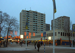
Dixi is a combined office, shopping and transport centre in Tikkurila, Vantaa, Finland, in connection to the Tikkurila railway station. Dixi is located to the west of the railway track, to the north of the old station building. The shopping centre was opened in 2015 and was expanded with a 100-metre-long (330 ft) expansion in 2017, with an upcoming final phase of a further 6,000 m2 (65,000 sq ft) of office space to its southern part on Ratatie.

<span class="mw-page-title-main">Buses in Helsinki</span> Overview of bus services in Helsinki

Local and regional bus services are a large part of public transport in the Helsinki region. HSL bus services include internal services in Helsinki, Espoo, Kauniainen, Vantaa, Kerava, Kirkkonummi, Sipoo, Siuntio and Tuusula and regional services between them.

References

  1. 1 2 3 Vantaan väestö 2013/2014 (PDF) (Report). Vantaa: City of Vantaa, Tietopalveluyksikkö. 20 August 2014. p. 33. ISBN   978-952-443-480-5. Archived from the original (PDF) on 2 February 2015. Retrieved 21 May 2015.
  2. Korson kunta Archived 2015-06-01 at the Wayback Machine , Socialist democratic workers' association of Korso. Accessed on 6 August 2011.
  3. Vantaan Laurin arkisto
  4. "Korson ytimeen tulee lisää asuntoja – tältä uusi keskusta voisi näyttää". Archived from the original on 2015-02-03. Retrieved 2015-02-03.