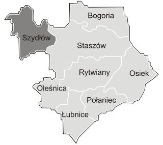
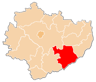
Czajków Południowy is a village in the administrative district of Gmina Staszów, within Staszów County, Świętokrzyskie Voivodeship, in south-central Poland. It lies approximately 10 kilometres (6 mi) east of Staszów and 60 km (37 mi) south-east of the regional capital Kielce.
Dobra is a village in the administrative district of Gmina Staszów, within Staszów County, Świętokrzyskie Voivodeship, in south-central Poland. It lies approximately 5 kilometres (3 mi) north-east of Staszów and 53 km (33 mi) south-east of the regional capital Kielce.
Oględów is a village in the administrative district of Gmina Staszów, within Staszów County, Świętokrzyskie Voivodeship, in south-central Poland. It lies approximately 4 kilometres (2 mi) west of Staszów and 51 km (32 mi) south-east of the regional capital Kielce.
Wiązownica Duża is a village in the administrative district of Gmina Staszów, within Staszów County, Świętokrzyskie Voivodeship, in south-central Poland. It lies approximately 14 kilometres (9 mi) east of Staszów and 63 km (39 mi) south-east of the regional capital Kielce.
Jurkowice is a village in the administrative district of Gmina Bogoria, within Staszów County, Świętokrzyskie Voivodeship, in south-central Poland. It lies approximately 8 kilometres (5 mi) east of Bogoria, 17 km (11 mi) north-east of Staszów, and 60 km (37 mi) south-east of the regional capital Kielce.
Brzeziny is a village in the administrative district of Gmina Szydłów, within Staszów County, Świętokrzyskie Voivodeship, in south-central Poland. It lies approximately 4 kilometres (2 mi) north-west of Szydłów, 16 km (10 mi) north-west of Staszów, and 39 km (24 mi) south-east of the regional capital Kielce.
Gacki is a village in the administrative district of Gmina Szydłów, within Staszów County, Świętokrzyskie Voivodeship, in south-central Poland. It lies approximately 3 kilometres (2 mi) south-east of Szydłów, 11 km (7 mi) west of Staszów, and 45 km (28 mi) south-east of the regional capital Kielce.
Grabki Duże is a village in the administrative district of Gmina Szydłów, within Staszów County, Świętokrzyskie Voivodeship, in south-central Poland. It lies approximately 4 kilometres (2 mi) west of Szydłów, 16 km (10 mi) west of Staszów, and 41 km (25 mi) south-east of the regional capital Kielce.
Jabłonica is a village in the administrative district of Gmina Szydłów, within Staszów County, Świętokrzyskie Voivodeship, in south-central Poland. It lies approximately 5 kilometres (3 mi) east of Szydłów, 8 km (5 mi) north-west of Staszów, and 46 km (29 mi) south-east of the regional capital Kielce.
Kotuszów is a village in the administrative district of Gmina Szydłów, within Staszów County, Świętokrzyskie Voivodeship, in south-central Poland. It lies approximately 6 kilometres (4 mi) east of Szydłów, 9 km (6 mi) north-west of Staszów, and 45 km (28 mi) south-east of the regional capital Kielce.
Mokre is a village in the administrative district of Gmina Szydłów, within Staszów County, Świętokrzyskie Voivodeship, in south-central Poland. It lies approximately 4 kilometres (2 mi) south-east of Szydłów, 9 km (6 mi) west of Staszów, and 46 km (29 mi) south-east of the regional capital Kielce.
Osówka is a village in the administrative district of Gmina Szydłów, within Staszów County, Świętokrzyskie Voivodeship, in south-central Poland. It lies approximately 3 kilometres (2 mi) north of Szydłów, 14 km (9 mi) north-west of Staszów, and 40 km (25 mi) south-east of the regional capital Kielce.
Potok is a village in the administrative district of Gmina Szydłów, within Staszów County, Świętokrzyskie Voivodeship, in south-central Poland. It lies approximately 8 kilometres (5 mi) north-west of Szydłów, 18 km (11 mi) north-west of Staszów, and 36 km (22 mi) south-east of the regional capital Kielce.
Potok Rządowy is a village in the administrative district of Gmina Szydłów, within Staszów County, Świętokrzyskie Voivodeship, in south-central Poland. It lies approximately 6 kilometres (4 mi) north of Szydłów, 17 km (11 mi) north-west of Staszów, and 38 km (24 mi) south-east of the regional capital Kielce.
Rudki is a village in the administrative district of Gmina Szydłów, within Staszów County, Świętokrzyskie Voivodeship, in south-central Poland. It lies approximately 11 kilometres (7 mi) north-west of Szydłów, 22 km (14 mi) north-west of Staszów, and 33 km (21 mi) south-east of the regional capital Kielce.
Stary Solec is a village in the administrative district of Gmina Szydłów, within Staszów County, Świętokrzyskie Voivodeship, in south-central Poland. It lies approximately 5 kilometres (3 mi) south-west of Szydłów, 15 km (9 mi) west of Staszów, and 43 km (27 mi) south-east of the regional capital Kielce.
Wola Żyzna is a village in the administrative district of Gmina Szydłów, within Staszów County, Świętokrzyskie Voivodeship, in south-central Poland. It lies approximately 4 kilometres (2 mi) south of Szydłów, 13 km (8 mi) west of Staszów, and 45 km (28 mi) south-east of the regional capital Kielce.
Wolica is a village in the administrative district of Gmina Szydłów, within Staszów County, Świętokrzyskie Voivodeship, in south-central Poland. It lies approximately 4 kilometres (2 mi) south-west of Szydłów, 15 km (9 mi) west of Staszów, and 42 km (26 mi) south-east of the regional capital Kielce.
Wymysłów is a village in the administrative district of Gmina Szydłów, within Staszów County, Świętokrzyskie Voivodeship, in south-central Poland. It lies approximately 6 kilometres (4 mi) north of Szydłów, 16 km (10 mi) north-west of Staszów, and 38 km (24 mi) south-east of the regional capital Kielce.