
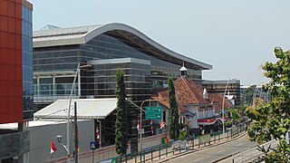
Kemayoran is a district (kecamatan) of Central Jakarta, Jakarta in Indonesia. It was best known for the former Kemayoran Airport and it has been transforming as a new central business district. As of 2023, it consists of numerous four and five-star hotels, restaurants, premium office towers, hospitals as well as shopping and entertainment centers. Kemayoran is also home to the Jakarta Fair, the largest and longest fair in Southeast Asia that attracts more than 4 million visitors annually.

Taman Sari is a district (kecamatan) of West Jakarta Administrative City, Indonesia. It is the smallest district of West Jakarta (4.37 km2). It is bounded by Central Jakarta to the south and to the east, and by Pademangan in North Jakarta to the north.
Jatinegara is one of the districts of the administrative city of East Jakarta, Indonesia. The name also refers to the larger, historic area of the colonial town of Meester Cornelis. Established in the 17th century, Jatinegara is one of the oldest areas in Jakarta, and contains a number of buildings from the colonial period.

Kota Tua Jakarta, officially known as Kota Tua, is a neighborhood comprising the original downtown area of Jakarta, Indonesia. It is also known as Oud Batavia, Benedenstad, or Kota Lama.

The Jakarta History Museum, also known as Fatahillah Museum or Batavia Museum, is located in the Old Town of Jakarta, Indonesia. The building was built in 1710 as the Stadhuis of Batavia. Jakarta History Museum opened in 1974 and displays objects from the prehistory period of the city region, the founding of Jayakarta in 1527, and the Dutch colonization period from the 16th century until Indonesia's Independence in 1945.

Ancol is a coastal lowland area located to the east of Kota Tua Jakarta in northern Jakarta, in Indonesia. The coastal lowland stretched from Kota Tua Jakarta to the west and Tanjung Priok to the east. Today, Ancol contains the main beach resort of Jakarta. Taman Impian Jaya Ancol, the largest integrated tourism area in Southeast Asia, is located in Ancol.

Colonial buildings and structures in Jakarta include those that were constructed during the Dutch colonial period of Indonesia. The period succeeded the earlier period when Jakarta, governed by the Sultanate of Banten, were completely eradicated and replaced with a walled city of Batavia. The dominant styles of the colonial period can be divided into three periods: the Dutch Golden Age, the transitional style period, and Dutch modernism. Dutch colonial architecture in Jakarta is apparent in buildings such as houses or villas, churches, civic buildings, and offices, mostly concentrated in the administrative city of Central Jakarta and West Jakarta.
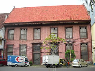
Toko Merah is a Dutch colonial landmark in Jakarta Old Town, Indonesia. Built in 1730, it is one of the oldest buildings in Jakarta. The building is located on the west side of the main canal Kali Besar. The building's red color contributes to its current name.

Jalan Gajah Mada and Jalan Hayam Wuruk, formerly Molenvliet West and Molenvliet Oost respectively, is a major thoroughfare located in Jakarta, Indonesia. The two streets with its canal, the Batang Hari, connect Glodok and Kota Tua Jakarta to the north with Harmoni Junction to the south. Completed in late 1640s, the canal-street Gajah Mada and Hayam Wuruk is Jakarta's oldest major thoroughfare.
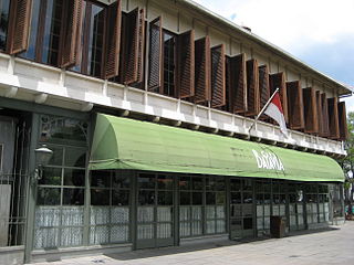
Cafe Batavia is a restaurant located in Kota Tua, Jakarta, Indonesia. It is one of the colonial landmarks facing the square Taman Fatahillah. The building where Cafe Batavia is established is the second oldest building in the square, second only to the former City Hall building of Batavia, which had been reestablished as the Jakarta History Museum.

Jayakarta Station (JAY) is a railway station serving by KRL Commuterline system. It is located at Jl. Pangeran Jayakarta. It is the named after a Banten prince with the same name.

Sawah Besar Station is a railway station, located on Jl. Kyai Haji Samanhudi. Altitude this station is 15 meters amsl, this station is one of seven elevated stations on Jakarta railway's Jakarta Kota–Manggarai segment, and is named after the Jakarta subdistrict with the same name. Pasar Baru market is within walking distance from this station.

The Jatikramat River is a river in Bekasi, West Java, and the eastern part of the Special Capital Region of Jakarta, Indonesia. The lower portions of the original river have been channelized and directed into the eastern flood canal, "Banjir Kanal Timur", which continues to flow to the Java Sea in the district of Marunda, Cilincing, North Jakarta. The river regularly causes flooding in the city of Bekasi and Jakarta.

Sunda Kelapa Lighthouse is a lighthouse located in Jakarta, Indonesia. Established in the mid-19th-century, it is among the oldest modern lighthouses in Indonesia.

Het kasteel van Batavia is a 17th-century painting by the Dutch painter Andries Beeckman. The painting depicts the Batavia Castle, the headquarter of the Dutch East India Company located in what is now Kota Tua in Jakarta, Indonesia. The painting is currently displayed in the Rijksmuseum in Amsterdam.
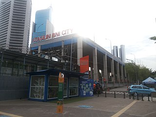
BNI City station is a station for the Soekarno-Hatta Airport Rail Link and KAI Commuter service. Bank Negara Indonesia (BNI) holds the naming rights for the station, which was known as Sudirman Baru station during construction period. The station is located in Central Jakarta, on the north bank of West Flood Canal, about a hundred meters from Sudirman Commuter Rail station. The station is part of Dukuh Atas TOD.
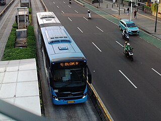
The Transjakarta Corridor 1 is the Transjakarta bus rapid transit route in Jakarta, Indonesia. The route operates between Blok M Terminal and Jakarta Kota railway station. It is the first route of the Transjakarta BRT system. The roads that are traversed by Corridor 1 are along Jalan Sultan Hasanuddin, Trunojoyo, Sisingamangaraja, Sudirman, MH Thamrin, Medan Merdeka Barat, Gajah Mada / Hayam Wuruk, Pintu Besar Utara, Kali Besar Barat, Kunir, and Lada Dalam. Key integration points include Dukuh Atas TOD that is currently an integration point for four transport modes, Jakarta Kota station which serves KRL Commuterline, and Harmoni station that is one of the main hubs in the BRT system. From Blok M to Bundaran HI ASTRA stations, this corridor is in parallel with North–South Line of the Jakarta MRT, thus many of the BRT stations are integrated directly with the MRT stations. Currently, all bus stations are served by buses 24 hours a day.

Kota is a Transjakarta bus rapid transit station located at the Old City of Batavia in Pinangsia, Taman Sari, West Jakarta, Jakarta, Indonesia. The station, which is the terminus of corridor 1, serves as the transit point for corridor 12. The name of this station comes from the name Kota Tua Jakarta and Jakarta Kota railway station, which are located adjacent to the BRT station.

Transjakarta Corridor 12 is a bus rapid transit corridor in Jakarta, Indonesia, operated by Transjakarta. It connects the Pluit BRT station to the Tanjung Priok bus terminal. The streets that passed by Corridor 12 are along Pluit Putri/Putra, Pluit Timur, Pluit Selatan, Jembatan Tiga, Bandengan Selatan, Gedong Panjang, Kopi, Tiang Bendera 5, Roa Malaka Utara, Tiang Bendera, Kunir, Lada Dalam, Bank, Kali Besar Barat, Jembatan Batu, Mangga Dua, Gunung Sahari, Angkasa, HBR Motik, Danau Sunter Barat, Danau Sunter Utara, Mitra Sunter Boulevard, Danau Sunter Selatan Dalam, Yos Sudarso, and Enggano streets. This corridor is integrated with Jakarta Kota Station at the Kota BRT station, Kampung Bandan Station at Mangga Dua BRT station, and also the Tanjung Priuk railway station at the Tanjung Priok terminal.
