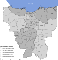
Batavia was the capital of the Dutch East Indies. The area corresponds to present-day Jakarta, Indonesia. Batavia can refer to the city proper or its suburbs and hinterland, the Ommelanden, which included the much-larger area of the Residency of Batavia in the present-day Indonesian provinces of Jakarta, Banten and West Java.

Ci Liwung is a 119 km long river in the northwestern region of Java where it flows through two provinces, West Java and the special region of Jakarta. The natural estuary of the Ciliwung river, known as the Kali Besar, was an important strategic point for trade in the precolonial and colonial periods and was instrumental in the founding of the port city of Jakarta, but has been lost from reorganization of the watercourse of the rivers around the area into canals.

The Mardijker people refers to an ethnic community in the Dutch East Indies made up of descendants of freed slaves. They could be found at all major trading posts in the East Indies. They were mostly Christian, of various ethnicity from conquered Portuguese and Spanish territories, and some with European ancestry. They spoke a Portuguese patois, which has influenced the modern Indonesian language.

Pasar Minggu is a district of South Jakarta, Jakarta, Indonesia. The area is known for its traditional Sunday market, famous for the fruit market. Historically, Pasar Minggu is a fruit cultivation area developed by the Dutch government during the colonial period. The central point of the cultivation area is the traditional market of Pasar Minggu, located in what is now Pasar Minggu Kelurahan. Teak forest could also be found in Pasar Minggu district, notably around Jati Padang Kelurahan. Most of these areas has been converted into residential area as Jakarta grow southward.

Sawah Besar is a district (kecamatan) of Central Jakarta, Indonesia. Its neighborhoods are among the most historic, containing the 1820-established Pasar Baru, the new colonial city – Weltevreden – and the old course of the Ciliwung river. Landmarks include the Lapangan Banteng, the government's 19th century-built, low-rise A.A. Maramis Building and its high palmed-lawned vista, and Jakarta Cathedral.
Taman Sari is a district of West Jakarta, Indonesia. It is the smallest subdistrict of West Jakarta (4.37 km2). It is bounded by Central Jakarta to the south and to the east, and by Pademangan in North Jakarta to the north.

Tambora is a subdistrict of West Jakarta, Indonesia. Tambora Subdistrict is bounded by a railway to the west and to the north, Kali Krukut - Kali Besar canal to the east, and Duri Selatan Road to the south.

Jatinegara is one of the districts (Kecamatan) of East Jakarta, Indonesia. The name also refers to the larger, historic area of the colonial town of Meester Cornelis. Established in the 17th century, Jatinegara is one of the oldest areas in Jakarta, and contains a number of buildings from the colonial period.

Penjaringan is a subdistrict of North Jakarta, Indonesia. It is the westernmost subdistrict of North Jakarta. Muara Angke port and the mouth of Sunda Kelapa Port are located within Penjaringan. Penjaringan contains the remnants of the original mangrove forest of Jakarta, some of which is protected by the Muara Angke Wildlife Sanctuary.

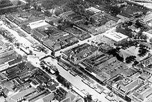
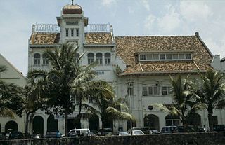
Kota Tua Jakarta, officially known as Kota Tua, is a neighborhood comprising the original downtown area of Jakarta, Indonesia. It is also known as Oud Batavia, Benedenstad, or Kota Lama.

Jakarta is Indonesia's capital and largest city. Located on an estuary of the Ciliwung River, on the northwestern part of Java, the area has long sustained human settlement. Historical evidence from Jakarta dates back to the 4th century CE, when it was a Hindu settlement and port. The city has been sequentially claimed by the Indianized kingdom of Tarumanegara, the Hindu Kingdom of Sunda, the Muslim Sultanate of Banten, and by Dutch, Japanese and Indonesian administrations. The Dutch East Indies built up the area before it was taken during World War II by the Empire of Japan and finally became independent as part of Indonesia.
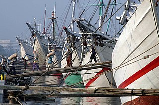
Sunda Kelapa is the old port of Jakarta located on the estuarine of Ciliwung River. "Sunda Kalapa" is the original name, and it was the main port of the Sunda Kingdom. The port is situated in Penjaringan sub-district, of North Jakarta, Indonesia. Today the old port only accommodate pinisi, a traditional two masted wooden sailing ship serving inter-island freight service in the archipelago. Although it is now only a minor port, Jakarta has its origins in Sunda Kelapa and it played a significant role in the city's development. The port is currently operated by the state-owned Indonesia Port Corporations.

The siege of Batavia was a military campaign led by Sultan Agung of Mataram to capture the Dutch port-settlement of Batavia in Java. The first attempt was launched in 1628, and the second in 1629; both were unsuccessful.

The Grogol River is a small river in the western part of the Special Capital Region of Jakarta, Indonesia. The lower portions of the original river have been channelized with levees built along its banks, but flooding remains a real concern. Illegal buildings built along its banks were removed in 2014, and fifty-eight village families were provided with replacement housing, but most of them could not be accommodated.

Fatahillah Square is the historical center of the old Batavia. The square is located at the center of Jakarta Old Town. Today the square is a tourist area home to the Jakarta History Museum, Wayang Museum and Fine Art and Ceramics Museum in Kota, Jakarta.
The Krukut River is a river flowing in Jakarta originating in Bogor Regency. In the past the river was clean and one of the tourist attractions during the Dutch East Indies administration, but due to denser housing on the banks and lack of maintenance, the water turned dark and filled with trash, causing routine flooding in rainy seasons.

Het kasteel van Batavia is a 17th-century painting by the Dutch painter Andries Beeckman. The painting depicts the Batavia Castle, the headquarter of the Dutch East India Company located in what is now Kota Tua in Jakarta, Indonesia. The painting is currently displayed in the Rijksmuseum in Amsterdam.
Baru Timur River is a man-made canal flowing from Ci Liwung in Bogor Regency to Jakarta, Indonesia. It was one of two canals built in the 18th century under the order of the Governor-General Gustaaf Willem van Imhoff originally to transport agriculture harvest from Bogor to Batavia. Currently both canals, now known as Kali Baru Timur and Kali Baru Barat, are among the main rivers in Jakarta, and part of the Ciliwung Cisadane flood control project. Baru Timur River flows from Katulampa flood gate, built at the same time as the canal, along the major road Bogor Highway, passing Cimanggis, Depok, Cilangkap, until reaching Java Sea in Kali Besar, Tanjung Priok, North Jakarta.
The Baru Barat River is a man-made canal flowing from the Cisadane River in Bogor Regency to Jakarta, Indonesia. It was one of two canals built in the 18th century under the order of the Governor-General Gustaaf Willem van Imhoff, originally to transport agricultural harvests from Bogor to Batavia. Currently both canals, now known as Kali Baru Timur and Kali Baru Barat, are among the main rivers in Jakarta, and part of the Ciliwung Cisadane flood control project. Flowing through the areas of Pancoran and Tebet, South Jakarta, among others, Baru Barat River is one of the drainages that flow the water into Banjir Kanal Barat.
Prinsen Straat, or Prince Street in English, was one of the busiest main streets in Batavia, Dutch East Indies where business and trade took place. It is now called Jalan Cengkeh in Jakarta. Jalan Cengkeh is located in the main area surrounding Kota Tua.