
Poonch or Punch is a district of the Jammu division of Indian-administered Jammu and Kashmir in the disputed Kashmir region. With headquarters in the town of Poonch, it is bounded by the Line of Control on three sides. The 1947–48 war between India and Pakistan divided the earlier district into two parts. One went to Pakistan and the other became part of the then-Indian state of Jammu and Kashmir.

Rajouri is a district in the Jammu division of Indian Jammu and Kashmir in the Kashmir region. The Line of Control, between the Indian- and Pakistan's occupied Jammu and Kashmir, lies to its west, Poonch to its north, the Reasi district to the east and the Jammu district to its south. Rajouri is famous for its "Kalari". Representing an ancient principality, Rajouri was a joint district, along with Reasi, at the time of the princely state's accession to India in 1947. The two tehsils were separated and Rajouri was merged with the Poonch district. Rajouri again became a separate district along with Reasi in 1968 till 2006 when both were separated again. The Rajouri district comprises 13 tehsils (boroughs). The land is mostly fertile and mountainous. Maize, wheat and rice are the main crops of the area and the main source of the irrigation is the river Tawi that originates from the mountains of Pir Panjal.

Bijbehara (Urdu pronunciation:[biːd͡ʒbɪɦɑːɽɑː], known as Vejibror in Kashmiri, is a town and a notified area committee in Anantnag district of the Indian administered union territory of Jammu and Kashmir. It is located on NH 44, and jehlum bank. Bijbehara town is also known as "Town of Chinars" because of a number of Chinars there especially two Chinar gardens. Bijbehara is the home to oldest chinar tree in the region. The town is situated about 45 km from the summer capital of union territory of Jammu and Kashmir, Srinagar.
Nowshera is a town and the headquarters of an eponymous tehsil of Rajouri district in the Jammu division of the Indian Union Territory of Jammu and Kashmir. It is governed by a Municipal committee and in rural area of Nowshera consists of 14 panchayats governed by local bodies under the supervision of district administration Rajouri.
Rajouri or Rajauri is a city in the Rajouri district in the Jammu division of the Indian union territory of Jammu and Kashmir. It is located about 155 kilometres (96 mi) from Srinagar and 150 km (93 mi) from Jammu city on the Poonch Highway.

Shopian, known as Shupyan in Kashmiri, is an administrative division of the Shopian district. It is located in southern part of Kashmir Valley, of Jammu and Kashmir, India. Shopian is called the ''Apple town of Kashmir'' as majority of the population engages in apple growing practices. It also provides employment to more than 60% of the population. It is 2nd richest district in Kashmir region after Srinagar.

Thanamandi is a town and a municipal committee in the Rajouri district in the Indian union territory of Jammu and Kashmir. Thanamandi lies on the Mughal Road between Rajouri and Bufliaz.
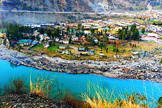
Ramban is a town in Ramban district of Jammu and Kashmir, India, which is the district headquarters of Ramban district. It lies on the banks of the Chenab river in Chenab Valley on the National Highway-1A at about 120 km from Jammu and about 130 km from Srinagar, making it almost the central point on the Jammu-Srinagar National Highway.

Reasi district is an administrative district in the Jammu division of Indian state of Jammu and Kashmir in the Jammu region. The Reasi district is bordered by Udhampur district and Ramban district in the east, Jammu district in the south, Rajouri district in the west and by Kulgam district on the north. The Reasi and Rajouri tehsils formed a joint district called the "Reasi district" at the time of the princely state's accession to India in 1947. As part of the reorganisation, the two tehsils were separated and Reasi was merged with the Udhampur district. It again became a separate district in 2006.
Rafiabad is a Tehsil in Baramulla of Jammu and Kashmir, India. The tehsil headquarters is in Rohama town. It is located to the west of Baramulla, about 12 km from district headquarters, and 70 km from the state capital Srinagar to the north west.

The Jammu division is a revenue and administrative division of the Indian-administered Jammu and Kashmir in the disputed Kashmir region. It is bordered by the Kashmir division to the north. It consists of the districts of Jammu, Doda, Kathua, Ramban, Reasi, Kishtwar, Poonch, Rajouri, Udhampur and Samba. Most of the land is hilly or mountainous, including the Pir Panjal Range which separates it from the Kashmir Valley and part of the Great Himalayas in the eastern districts of Doda and Kishtwar. Its principal river is the Chenab.
Budhal is a tehsil in Rajouri district, Jammu and Kashmir, India. It is named after the village of Budhal, which is located at a distance of 57 KM from District headquarters Rajouri. Budhal Tehsil is bounded by Darhal Tehsil towards west, Thana Mandi Tehsil towards west, Mahore Tehsil towards East, Rajouri towards west. There are 51 villages in Budhal tehsil which is one of the largest tehsil in Rajouri district. Budhal is very beautiful place There are many unexplored lakes on the hill top of Budhal . There is a Degree College in Budhal having Science and Arts streams. GOVT.Degree College Budhal was established in 2008 by the then Government of Jammu and Kashmir INC

Akingam is a village in South Kashmir in the Anantnag district, in the Indian union territory of Jammu and Kashmir. It is at a distance of approximately 14.2 kilometres (8.8 mi) from the Lal Chowk along a route passing through the tourist resorts of Achabal and Kokernag. In revenue records, the village of Akingam is still called Maqan Shiva Bhagwati. The adjacent villages are Mohripura, Hiller, Badasgam, Hardpora and Badoora.
Herman or Hermain is a village and tehsil located in Shopian district of Jammu and Kashmir, India. It is situated 8.71 km (5.41 mi) away from its main town Shopian, the district headquarters of Shopian district. Herman was made a tehsil in 2014 by the State government of Jammu and Kashmir. Herman has 29 villages. In Herman there is a tehsil office in which a Tehsildar is serving the people.

Jammu and Kashmir is a region administered by India as a union territory and consists of the southern portion of the larger Kashmir region, which has been the subject of a dispute between India and Pakistan since 1947 and between India and China since 1959. The Line of Control separates Jammu and Kashmir from the Pakistani-administered territories of Azad Kashmir and Gilgit-Baltistan in the west and north. It lies to the north of the Indian states of Himachal Pradesh and Punjab and to the west of Ladakh which is administered by India as a union territory.
Teetwal is a small border-village in Jammu and Kashmir, India. It is situated on the banks of the Kishanganga River in Kupwara district, 82 km (51 mi) from the district headquarters of Kupwara and close to the Line of Control with Pakistani-administered Kashmir. Teetwal is connected to the rest of India via Tangdhar.
Mandi is a village and municipality in Poonch district of the Indian union territory of Jammu and Kashmir. The town is located 20 km (12 mi) from the district headquarters Poonch.
Azmatabad is a village, near Rajouri City in Thanamandi tehsil in Rajouri district of the Indian union territory of Jammu and Kashmir.
Otligam is a village in tehsil Beerwah of district Budgam of the Jammu and Kashmir. Village plays an important role with respect to education, banking facilities as well as the road connectivity of adjoining villages. Besides this the village has a Primary Health Centre set by Ministry of Ayush.
Sialsui is a village in Rajouri district of the Indian union territory of Jammu and Kashmir in India. As per Census 2011 report, the location code or village code of Sialsui village is 001507. It is located 20 km towards the South from Rajouri, which is the district and 15 km away from the sub-district headquarter Kalakote of Sialsui village.

