Kotuy River

Last updated

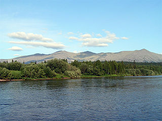
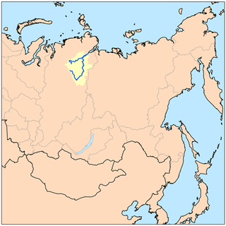
The Kotuy River (Russian : Котуй) is a river in Krasnoyarsk Krai, Russia. It is one of the two rivers that form the Khatanga River; the other one being the Kheta River.

Russian language East Slavic language

Russian is an East Slavic language, which is official in the Russian Federation, Belarus, Kazakhstan and Kyrgyzstan, as well as being widely used throughout Eastern Europe, the Baltic states, the Caucasus and Central Asia. It was the de facto language of the Soviet Union until its dissolution on 25 December 1991. Although nearly three decades have passed since the breakup of the Soviet Union, Russian is used in official capacity or in public life in all the post-Soviet nation-states, as well as in Israel and Mongolia.

River Natural flowing watercourse

A river is a natural flowing watercourse, usually freshwater, flowing towards an ocean, sea, lake or another river. In some cases a river flows into the ground and becomes dry at the end of its course without reaching another body of water. Small rivers can be referred to using names such as stream, creek, brook, rivulet, and rill. There are no official definitions for the generic term river as applied to geographic features, although in some countries or communities a stream is defined by its size. Many names for small rivers are specific to geographic location; examples are "run" in some parts of the United States, "burn" in Scotland and northeast England, and "beck" in northern England. Sometimes a river is defined as being larger than a creek, but not always: the language is vague.

Krasnoyarsk Krai First-level administrative division of Russia

Krasnoyarsk Krai is a federal subject of Russia, with its administrative center in the city of Krasnoyarsk—the third-largest city in Siberia. Comprising half of the Siberian Federal District, Krasnoyarsk Krai is the largest krai in the Russian Federation, the second largest federal subject and the third largest subnational governing body by area in the world, after Sakha and the Australian state of Western Australia. The krai covers an area of 2,339,700 square kilometers (903,400 sq mi), which is nearly one quarter the size of the entire country of Canada, constituting roughly 13% of the Russian Federation's total area and containing a population of 2,828,187, or just under 2% of its population, per the 2010 Census.

The Kotuy River is 1,409 kilometres (876 mi) long, and the area of its basin is 176,000 square kilometres (68,000 sq mi). It freezes up in late September or early October and breaks up in late May or early June. Its main tributaries are the Moyero, the Kotuykan, the Eriyechka, the Changada, and the Tukalan.

Area Quantity that expresses the extent of a two-dimensional surface or shape, or planar lamina, in the plane

Area is the quantity that expresses the extent of a two-dimensional figure or shape, or planar lamina, in the plane. Surface area is its analog on the two-dimensional surface of a three-dimensional object. Area can be understood as the amount of material with a given thickness that would be necessary to fashion a model of the shape, or the amount of paint necessary to cover the surface with a single coat. It is the two-dimensional analog of the length of a curve or the volume of a solid.

Drainage basin Area of land where precipitation collects and drains off into a common outlet

A drainage basin is any area of land where precipitation collects and drains off into a common outlet, such as into a river, bay, or other body of water. The drainage basin includes all the surface water from rain runoff, snowmelt, and nearby streams that run downslope towards the shared outlet, as well as the groundwater underneath the earth's surface. Drainage basins connect into other drainage basins at lower elevations in a hierarchical pattern, with smaller sub-drainage basins, which in turn drain into another common outlet.

Tributary stream or river that flows into a main stem river or lake

A tributary or affluent is a stream or river that flows into a larger stream or main stem river or a lake. A tributary does not flow directly into a sea or ocean. Tributaries and the main stem river drain the surrounding drainage basin of its surface water and groundwater, leading the water out into an ocean.

Coordinates: 71°54′54″N102°07′22″E / 71.9150°N 102.1228°E / 71.9150; 102.1228

Geographic coordinate system Coordinate system

A geographic coordinate system is a coordinate system that enables every location on Earth to be specified by a set of numbers, letters or symbols. The coordinates are often chosen such that one of the numbers represents a vertical position and two or three of the numbers represent a horizontal position; alternatively, a geographic position may be expressed in a combined three-dimensional Cartesian vector. A common choice of coordinates is latitude, longitude and elevation. To specify a location on a plane requires a map projection.


Related Research Articles

Kostroma River river in Russia

The Kostroma is a river in the European part of Russia. It flows through the Kostroma and Yaroslavl Oblasts, and becomes a left tributary of the Volga, which it enters at the Gorky Reservoir, at the city of Kostroma, at 57°46′44″N 40°53′55″E.

Kolyma River river in Russia

The Kolyma River is a river in northeastern Siberia, whose basin covers parts of the Sakha Republic, Chukotka Autonomous Okrug, and Magadan Oblast of Russia. It begins at the confluence of the Kulu River and the Ayan Yuryakh River and empties into the Kolyma Gulf of the East Siberian Sea, a division of the Arctic Ocean, at 69°30′N 161°30′E. The Kolyma is 2,129 kilometres (1,323 mi) long. The area of its basin is 644,000 square kilometres (249,000 sq mi).

Ufa River river in Russia

Ufa River is a river in the Urals, Chelyabinsk Oblast, Sverdlovsk Oblast, and the Republic of Bashkortostan; a tributary of the Belaya River. It is 918 kilometres (570 mi) long, and its basin covers 53,100 square kilometres (20,500 sq mi). It freezes up between late October and early December and stays under the ice until April or May. Pavlovka Hydroelectric Station is along the Ufa. The river's water is widely used for water supply. The main ports are Krasnoufimsk and Ufa.

Indigirka River river in Russia

The Indigirka River is a river in the Sakha Republic in Russia between the Yana River and the Kolyma River. It is 1,726 kilometres (1,072 mi) long. The area of its basin is 360,000 square kilometres (140,000 sq mi). The river flows into the Kolyma Bay, East Siberian Sea. It freezes up in October and stays under the ice until May–June.

Yana River river in Russia

The Yana River, is a river in Sakha in Russia, located between the Lena to the west and the Indigirka to the east.

Vyatka River river in Russia

The Vyatka River is a river in Kirov Oblast and the Republic of Tatarstan in Russia, a right tributary of the Kama River. It is 1,314 kilometres (816 mi) long, and its drainage basin covers 129,000 square kilometres (50,000 sq mi).

Vishera River (Perm Krai) river in Perm Krai, Russia

The Vishera River (Вишера) is a river in Perm Krai, Russia, a left bank tributary of the Kama River. It is 415 kilometres (258 mi) long, and its drainage basin covers 31,200 square kilometres (12,000 sq mi). The Vishera River freezes in late October or early November and stays under the ice until the end of April. There are diamond deposits in the basin of the Vishera River.

Khatanga River river in Russia

The Khatanga River is a river in Krasnoyarsk Krai in Russia. It begins at the confluence of the rivers Kotuy and Kheta. The Khatanga River is 227 kilometres (141 mi) long; the area of its basin is 364,000 square kilometres (141,000 sq mi). It flows into the Khatanga Gulf of the Laptev Sea, forming an estuary. There are more than 112,000 lakes, with a total surface area of 11,600 square kilometres (4,500 sq mi), in the basin of the river.

Pra River is a river in the Ryazan and Moscow Oblasts in Russia, a left tributary of the Oka River. It is 167 kilometres (104 mi) in length. The area of its basin is 5,520 square kilometres (2,130 sq mi). The Pra River freezes up in late November and stays under the ice until April.

Protva River river in Russia

Protva River is a river in Moscow and Kaluga Oblasts in Russia, left tributary of the Oka. The length of the river is 282 kilometres (175 mi). The area of its basin is 4,620 square kilometres (1,780 sq mi). The Protva freezes up in early December and stays icebound until early April. Its main tributary is the Luzha River. The towns of Vereya, Borovsk, Protvino and Obninsk are located on the shores of the Protva River.

Zhizdra River is a river in Kaluga Oblast in Russia, Oka's left tributary. The length of the river is 223 kilometres (139 mi). The area of its basin is 9,170 square kilometres (3,540 sq mi). the Zhizdra River freezes up in late November and stays icebound until early April. Its main tributaries are the Resseta, Vytebet, and Serena. The towns of Kozelsk and Zhizdra are located on the shores of the Zhizdra. The name is of Baltic origin.

Aragvi River river in Georgia

The Aragvi River and its basin are in Georgia on the southern slopes of the Caucasus Mountains. The river is 112 kilometres (70 mi) long, and its basin covers an area of 2,724 square kilometres (1,052 sq mi). The ground strata are mostly sandstone, slate, and limestone. The Zhinvali Dam and its 130 MW hydro-electric power station generate much of Georgia’s power, and its construction in 1986 formed the Zhinvali Reservoir, upon whose north-western shores rises Ananuri castle with its 17th-century Church of the Assumption.

Tavda River river in Russia

The Tavda River is a Siberian river that drains part of the central Ural mountains into the Tobol River. It is north of the Tura River and south of the Konda River. It is located in Sverdlovsk Oblast and Tyumen Oblast.

Ilim River is a river in Irkutsk Oblast in Russia, a right tributary of the Angara River. It flows north between and parallel to the Angara and Lena Rivers, and then swings west to join the Angara 40 kilometres (25 mi) south of Ust-Ilimsk.

Pronya River is a river in Ryazan and Tula Oblasts in Russia, a right tributary of the Oka River. The length of the river is 336 kilometres (209 mi). The area of its basin is 10,200 square kilometres (3,900 sq mi). The river freezes up in late November and stays icebound until early March. The Pronya is navigable in its lower reaches. The town of Mikhailov is located on the Pronya River.

Kheta River is a river in Krasnoyarsk Krai in Russia, left composite of the Khatanga River. The river is 604 kilometres (375 mi) long. The area of its drainage basin is 100,000 square kilometres (39,000 sq mi). The Kheta is formed by the confluence of the Ayan and Ayakli Rivers, both of which originate in the Putoran plateau. The Kheta freezes up in late September or early October and breaks up in late May or the first half of June. Its main tributaries are the Boyarka, Maimecha, and Boganida Rivers.

Konda River river in Russia

Konda is a river in the Khanty–Mansia district of Russia. The town of Uray and the Shaimskoye oil field are along the Konda.

Bolshoy Uzen River river

The Bolshoy Uzen is a river in Saratov Oblast of Russia and West Kazakhstan Province of Kazakhstan. It is 650 kilometres (400 mi) long, with a drainage basin of 15,600 square kilometres (6,000 sq mi).

Ulya River is a river in northern Khabarovsk Krai in Russia. The length of the river is 325 kilometres (202 mi), the area of its drainage basin is 15,500 square kilometres (6,000 sq mi). The Ulya originates in the Dzhugdzhur Mountains, flows northeast parallel to the coast and turns east to reach the Sea of Okhotsk about 100 kilometres (62 mi) southwest of Okhotsk. It freezes up in late October through early November and remains icebound until May. The first Russian to reach the Pacific Ocean was Ivan Moskvitin who sailed down the Ulya and wintered near its mouth in 1639. Vasili Poyarkov reused his huts in 1646. The Ulya was one of the water routes to and from Okhotsk. From its tributaries either the Lama Portage or the Alachak Portage led to the Mati River which flows north to the Maya River, which leads to the Aldan River and then Lena River to Yakutsk.

The Aktay or Aqtay is a river in Tatarstan, Russian Federation, a left-bank tributary of the Volga River, falling into the Kuybyshev Reservoir near Izmeri. It is 89 kilometres (55 mi) long, and its drainage basin covers 1,016 square kilometres (392 sq mi).