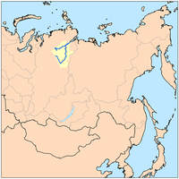
The Yana River, is a river in Sakha in Russia, located between the Lena to the west and the Indigirka to the east.

The Vyatka River is a river in Kirov Oblast and the Republic of Tatarstan in Russia, a right tributary of the Kama River. It is 1,314 kilometres (816 mi) long, and its drainage basin covers 129,000 square kilometres (50,000 sq mi).
The Pur River is a river in the Yamalo-Nenets Autonomous Okrug in Russia. The Pur River proper starts at the confluence of the Pyakupur and Aivasedapur Rivers. The Pur River is 389 kilometres (242 mi) long. It is often considered as the Pyakupur's extension, which would make it 1,024 kilometres (636 mi) long. The area of its basin is 112,000 square kilometres (43,000 sq mi).
Kirenga River is a river in Irkutsk Oblast in Russia, a right tributary of the Lena which flows north between the upper Lena and Lake Baikal. The length of the river is 746 kilometres (464 mi). The area of its basin is 46,600 square kilometres (18,000 sq mi). The Kirenga River freezes up in late October to early November and stays under the ice until late April to May. Its main tributaries are the Ulkan, Minya, and Khanda. The Kirenga River begins in the Baikal Mountains 6 kilometres (4 mi) west of Lake Baikal, a few dozen kilometres north of the source of the Lena. The Baikal Amur Mainline follows and crosses the Kirenga between Magistralnyy and Ulkan. It joins the Lena at the town of Kirensk. The average consumption of water - in the mouth - 651 m³ / s. It is fed mainly by rain.

The Alazeya River is a river in the northeastern part of Yakutia, Russia which flows into the Arctic between the basins of the larger Indigirka River to the west and the Kolyma River to the east.

Protva River is a river in Moscow and Kaluga Oblasts in Russia, left tributary of the Oka. The length of the river is 282 kilometres (175 mi). The area of its basin is 4,620 square kilometres (1,780 sq mi). The Protva freezes up in early December and stays icebound until early April. Its main tributary is the Luzha River. The towns of Vereya, Borovsk, Protvino and Obninsk are located on the shores of the Protva River.
Zhizdra River is a river in Kaluga Oblast in Russia, Oka's left tributary. The length of the river is 223 kilometres (139 mi). The area of its basin is 9,170 square kilometres (3,540 sq mi). the Zhizdra River freezes up in late November and stays icebound until early April. Its main tributaries are the Resseta, Vytebet, and Serena. The towns of Kozelsk and Zhizdra are located on the shores of the Zhizdra. The name is of Baltic origin.
Letka River is a river in the Komi Republic and Kirov Oblast in Russia, an arm of the Vyatka River. The river is 260 kilometres (160 mi) long, and its drainage basin covers 3,680 square kilometres (1,420 sq mi). The Letka is navigable along its lower reaches.
Ilych River is a river in the Komi Republic in northwest Russia. It drains part of the northern Ural Mountains westward into the upper Pechora River. The river is 411 kilometres (255 mi) long, and the area of its drainage basin is 16,000 square kilometres (6,200 sq mi). The Ilych freezes up in early November and stays icebound until late April. Its main tributaries are the Kogel and Palyu rivers. The Pechora-Ilych Nature Reserve lies along the left bank of the Ilych River.

Uchur River is a river in Khabarovsk Krai and Yakutia in Russia, a right tributary of the Aldan River. The length of the river is 812 kilometres (505 mi). The area of its drainage basin is 113,000 square kilometres (44,000 sq mi). The Uchur freezes up in November and breaks up in May. Its main tributaries are the Uyan, Tyrkan, Gonam, and Gynym Rivers.
Kheta River is a river in Krasnoyarsk Krai in Russia, left composite of the Khatanga River. The river is 604 kilometres (375 mi) long. The area of its drainage basin is 100,000 square kilometres (39,000 sq mi). The Kheta is formed by the confluence of the Ayan and Ayakli Rivers, both of which originate in the Putoran plateau. The Kheta freezes up in late September or early October and breaks up in late May or the first half of June. Its main tributaries are the Boyarka, Maimecha, and Boganida Rivers.
The Boganida River is a river in Krasnoyarsk Krai in Russia. It is a left tributary of the Kheta River. The river is 366 kilometres (227 mi) long, and its drainage basin covers 10,700 square kilometres (4,100 sq mi). The Boganida River is formed by the confluence of the Kegerdi and Khopsokkon Rivers, which both originate from Lake Labaz.
Maimecha River, also known as Medvezh'ya River, is a river in Evenk and Taymyr Autonomous Okrugs of Krasnoyarsk Krai in Russia, right composite of the Kheta River. The length of the river is 650 kilometres (400 mi). The area of its drainage basin is 26,500 square kilometres (10,200 sq mi).
Moma River is a river in Yakutia in Russia, a right tributary of the Indigirka River.
Uyandina River is a river in Yakutia in Russia, a left tributary of the Indigirka River. It is formed by the confluence of the Irgichyan and Baky Rivers. The length of the Uyandina is 586 kilometres (364 mi). The area of its drainage basin is 177,000 square kilometres (68,000 sq mi). The Uyandina freezes up in October and remains icebound until late May or early June.
Ulya River is a river in northern Khabarovsk Krai in Russia. The length of the river is 325 kilometres (202 mi), the area of its drainage basin is 15,500 square kilometres (6,000 sq mi). The Ulya originates in the Dzhugdzhur Mountains, flows northeast parallel to the coast and turns east to reach the Sea of Okhotsk about 100 kilometres (62 mi) southwest of Okhotsk. It freezes up in late October through early November and remains icebound until May. The first Russian to reach the Pacific Ocean was Ivan Moskvitin who sailed down the Ulya and wintered near its mouth in 1639. Vasili Poyarkov reused his huts in 1646. The Ulya was one of the water routes to and from Okhotsk. From its tributaries either the Lama Portage or the Alachak Portage led to the Mati River which flows north to the Maya River, which leads to the Aldan River and then Lena River to Yakutsk.

The Nura River is a major watercourse of northeast-central Kazakhstan. It is about 978 kilometres (608 mi) long and drains an area of 58,100 square kilometres (22,400 sq mi).
Bolshoy Yugan is a river in Russia, it flows through the territory of Surgutsky and Nefteyugansky Districts of Khanty-Mansi Autonomous Okrug, it is a left tributary of the Ob River, it flows into the Yuganskaya Ob. The length of the river is 1,063-kilometre (661 mi), its basin area is 34,700-square-kilometre (13,400 sq mi). The average annual water consumption at 118-kilometre (73 mi) from the mouth of the river is 177.67-cubic-metre-per-second (6,274 cu ft/s).

The Cao'e River is one of the largest rivers in Zhejiang Province of East China, named after Cao E, a Han dynasty girl venerated for her filial piety. Its main source is in Pan'an County in the Dapan Mountains, and the river empties into the Hangzhou Bay near the Qiantang River estuary. It has a total length of 182.4 kilometres (113.3 mi), and a basin area of 5,930.9 square kilometres (2,289.9 sq mi).