
The Struve Geodetic Arc is a chain of survey triangulations stretching from Hammerfest in Norway to the Black Sea, through ten countries and over 2,820 km, which yielded the first accurate measurement of a meridian.

Erzgebirgsstadion is a multi-purpose stadium in Aue, Germany. It is currently used mostly for football matches and is the home stadium of FC Erzgebirge Aue. The stadium is able to hold 16,485 people and was built in 1950.
Wojciechowice is a village in the administrative district of Gmina Kłodzko, within Kłodzko County, Lower Silesian Voivodeship, in south-western Poland. Prior to 1945 it was in Germany. It lies approximately 5 kilometres (3 mi) east of Kłodzko and 79 km (49 mi) south of the regional capital Wrocław.
Argahandab District is a district of Zabul Province, Afghanistan.

Kończyce is a village in the administrative district of Gmina Nowe, within Świecie County, Kuyavian-Pomeranian Voivodeship, in north-central Poland. It lies approximately 2 kilometres (1 mi) south-west of Nowe, 31 km (19 mi) north-east of Świecie, and 68 km (42 mi) north of Toruń.
Bagno is a settlement in the administrative district of Gmina Gródek, within Białystok County, Podlaskie Voivodeship, in north-eastern Poland, close to the border with Belarus.
Dębowiec is a village in the administrative district of Gmina Wielgomłyny, within Radomsko County, Łódź Voivodeship, in central Poland. It lies approximately 6 kilometres (4 mi) north-west of Wielgomłyny, 19 km (12 mi) east of Radomsko, and 83 km (52 mi) south of the regional capital Łódź.
Chlebów is a village in the administrative district of Gmina Lipce Reymontowskie, within Skierniewice County, Łódź Voivodeship, in central Poland. It lies approximately 4 kilometres (2 mi) north of Lipce Reymontowskie, 15 km (9 mi) west of Skierniewice, and 37 km (23 mi) north-east of the regional capital Łódź.
Ludwików is a village in the administrative district of Gmina Skierniewice, within Skierniewice County, Łódź Voivodeship, in central Poland. It lies approximately 3 kilometres (2 mi) south of Skierniewice and 49 km (30 mi) east of the regional capital Łódź.
Elżbieta-Kolonia is a village in the administrative district of Gmina Opole Lubelskie, within Opole Lubelskie County, Lublin Voivodeship, in eastern Poland.
Jedle is a village in the administrative district of Gmina Łopuszno, within Kielce County, Świętokrzyskie Voivodeship, in south-central Poland. It lies approximately 3 kilometres (2 mi) south-west of Łopuszno and 28 km (17 mi) west of the regional capital Kielce.
Gliniany is a village in the administrative district of Gmina Ożarów, within Opatów County, Świętokrzyskie Voivodeship, in south-central Poland. It lies approximately 5 kilometres (3 mi) north-west of Ożarów, 20 km (12 mi) north-east of Opatów, and 72 km (45 mi) east of the regional capital Kielce.
Bolesławowo is a village in the administrative district of Gmina Serock, within Legionowo County, Masovian Voivodeship, in east-central Poland.
Zdonków is a village in the administrative district of Gmina Borkowice, within Przysucha County, Masovian Voivodeship, in east-central Poland.
Malewo is a village in the administrative district of Gmina Gostyń, within Gostyń County, Greater Poland Voivodeship, in west-central Poland. It lies approximately 6 kilometres (4 mi) north of Gostyń and 53 km (33 mi) south of the regional capital Poznań.
Kolnik is a village in the administrative district of Gmina Pszczółki, within Gdańsk County, Pomeranian Voivodeship, in northern Poland. It lies approximately 3 kilometres (2 mi) south-east of Pszczółki, 14 km (9 mi) south of Pruszcz Gdański, and 24 km (15 mi) south of the regional capital Gdańsk.
Gilwa is a village in the administrative district of Gmina Prabuty, within Kwidzyn County, Pomeranian Voivodeship, in northern Poland. It lies approximately 6 kilometres (4 mi) south-west of Prabuty, 15 km (9 mi) east of Kwidzyn, and 81 km (50 mi) south-east of the regional capital Gdańsk.
Rozłazino is a settlement in the administrative district of Gmina Tychowo, within Białogard County, West Pomeranian Voivodeship, in north-western Poland. It lies approximately 10 kilometres (6 mi) west of Tychowo, 12 km (7 mi) south-east of Białogard, and 117 km (73 mi) north-east of the regional capital Szczecin.
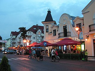
Pobierowo is a village in the administrative district of Gmina Rewal, within Gryfice County, West Pomeranian Voivodeship, in north-western Poland. It lies approximately 7 kilometres (4 mi) south-west of Rewal, 24 km (15 mi) north-west of Gryfice, and 75 km (47 mi) north of the regional capital Szczecin.
Turzyniec is a settlement in the administrative district of Gmina Myślibórz, within Myślibórz County, West Pomeranian Voivodeship, in north-western Poland.


