
The Orange River is a river in Southern Africa. It is the longest river in South Africa. With a total length of 2,432 km (1,511 mi), the Orange River Basin extends from Lesotho into South Africa and Namibia to the north. It rises in the Drakensberg mountains in Lesotho, flowing westwards through South Africa to the Atlantic Ocean. The river forms part of the international borders between South Africa and Lesotho and between South Africa and Namibia, as well as several provincial borders within South Africa. Except for Upington, it does not pass through any major cities. The Orange River plays an important role in the South African economy by providing water for irrigation and hydroelectric power. The river was named the Orange River in honour of the Dutch ruling family, the House of Orange, by the Dutch explorer Robert Jacob Gordon. Other names include simply the word for river, in Khoekhoegowab orthography written as !Garib, which is rendered in Afrikaans as Gariep River with the intrusion of a velar fricative in place of the alveolar click, Groote River or Senqu River, derived from ǂNū "Black". It is known in isiZulu as isAngqu

The Northern Cape is the largest and most sparsely populated province of South Africa. It was created in 1994 when the Cape Province was split up. Its capital is Kimberley. It includes the Kalahari Gemsbok National Park, part of the Kgalagadi Transfrontier Park and an international park shared with Botswana. It also includes the Augrabies Falls and the diamond mining regions in Kimberley and Alexander Bay.
Macdonald River, a perennial river that is part of the Namoi catchment within the Murray–Darling basin, is located in the Northern Tablelands district of New South Wales, Australia.

The Great Kei River is a river in the Eastern Cape province of South Africa. It is formed by the confluence of the Black Kei River and White Kei River, northeast of Cathcart. It flows for 320 km (199 mi) and ends in the Great Kei Estuary at the Indian Ocean with the small town Kei Mouth on the west bank. Historically the Great Kei River formed the southwestern border of the Transkei region as was formerly known as the Nciba River.
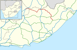
The R58 is a provincial route in South Africa that connects Colesberg with Ngcobo via Aliwal North, Barkly East and Khowa.
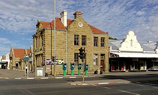
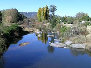
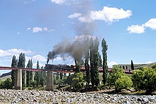
Aliwal North is a town in central South Africa on the banks of the Orange River, Eastern Cape Province. It is a medium-sized commercial centre in the northernmost part of the Eastern Cape.
The Mira River is a Canadian river located in eastern Cape Breton Island, Nova Scotia.

Lourens Jacobus (Louw) Wepener was born on 21 July 1812. He was the son of a German immigrant – Frederick Jacobus Wepener – and a Cape Colony woman – Johanna Maria Erasmus. Wepener was born in Graaf-Reinet and lived with his uncle – Lourens. He was christened by Reverend Andrew Murray of the Dutch Reformed Church. Wepener was first married to Hester Susanna Nel and then later to Hilletje Maria Levina Van Aardt. He had nine children with his second wife.

Barkly East is a town in Eastern Cape Province, South Africa, seat of the Joe Gqabi District Municipality, and 117 km by road E.S.E. of Aliwal North, lying in the mountainous area just south of Lesotho. The town lies at the southern tip of the Drakensberg on the Langkloofspruit, a tributary of the Kraai River which, in turn is a tributary of the Orange River at an elevation of 1 790 meter above sealevel. Barkly East is characterized by rugged mountains and green valleys. Snow falls in winter, and the hamlet of Rhodes is 60 km or an hour's drive from Barkly East on the R396. Both are within the boundaries of the Senqu Local Municipality.

Lady Grey is a rural village in the North of the Eastern Cape in South Africa near the border with Lesotho. It is situated in the foothills of the Witteberg mountains, 54 km (34 mi) due east of Aliwal North on the R58 road and 260 km (160 mi) from the capital of the Free State Province, Bloemfontein.

Rhodes is a hamlet or small village alongside the wild trout rich Bell River, near Ben Macdhui in the Drakensberg mountains of the north Eastern Cape, South Africa.

Johann Fran(t)z Drège, commonly referred to by his standard botanical author abbreviation Drège, was a German horticulturalist, botanical collector and explorer of Huguenot descent.
The Bell River is a river that drains the Drakensberg uplands of the Eastern Cape province of South Africa. Its drainage basin, a part of the headwaters of the Orange River, is approximately 424 square kilometres (160 sq mi) in extent, ranging from an altitude of 1,720 m (a.m.s.l.) to 3,001 m. The river's source is near the Lesotho border to the north of the high Naude's Neck Pass. Downstream it passes the town of Rhodes, to eventually form a tributary of the Kraai River some 40 km (direct) from its source. In fact the Bell River and the Sterkspruit, become the Kraai River just northwest of Moshesh's Ford flowing further west towards Aliwal North, where it joins the Orange River.

The Bronkhorst Spruit, meaning watercress stream or creek, is a river in the Mpumalanga and Gauteng provinces of South Africa. In the 19th century it as was known as the Kalkoenkransrivier or Rhenosterpoortrivier. It is a tributary of the Wilge River in the Olifants River basin, and it lends its name to the town of Bronkhorstspruit, situated mainly on its right bank.

The Mogalakwena River is one of the main watercourses in Limpopo Province, South Africa. It is also a major tributary of the Limpopo River.

The border between Lesotho and South Africa is 909 kilometres (565 mi) long and forms a complete loop, as Lesotho is an enclave entirely surrounded by South Africa. The border follows the Caledon River, the drainage divide of the Drakensberg mountains, the Orange River, the Makhaleng River, and a series of hills joining the Makhaleng back to the Caledon.
The Karringmelk Spruit is a tributary of the Kraai River in the Senqu area in the northeastern part of the Eastern Cape. It rises to the south of Wittenberg near Lesotho and flows as a stream southwestward through valleys and gorges east of the town of Lady Grey and further south to where it joins the Kraai River at 30°54′20″S27°07′58″E.

Eastern Province Command was a command of the South African Army.

Bell Creek is a tributary of Tunkhannock Creek in Susquehanna County, Pennsylvania, in the United States. It is approximately 5.2 miles (8.4 km) long and flows through Gibson Township. The watershed of the creek has an area of 5.64 square miles (14.6 km2). The surficial geology the creek's vicinity includes Wisconsinan Till, alluvium, bedrock, wetlands, lakes, and alluvial fan. It has no named tributaries, but does flow through a lake known as Potter Lake. A bridge on the National Register of Historic Places crosses Bell Creek as well. The creek's watershed is designated as a Coldwater Fishery and a Migratory Fishery.

The Buffelskloof Formation is a geological formation found in the Western Cape province in South Africa. It is the uppermost of the four formations found within the Uitenhage Group of the Algoa Basin. It is considered an informal formation by some of the literature as it is very thin and only outcrops as isolated horizons in the Oudshoorn-Gamtoos, Herbertsdale-Mossel Bay, and Heidelberg-Riversdale Basins. Along the Worcester-Pletmos Basin, it occurs in patches along the southern flanks of the Langeberg mountain range - from Worcester in the west and as far as Mossel Bay in the east. From Mossel Bay this formation is inter fingered by the informal Hartenbos Formation. The Buffelskloof and Hartenbos Formations only occur in the Oudshoorn-Gamtoos and Herbertsdale-Mossel Bay basins and seem to correlate to the Sundays River Formation in age.


