Bartodzieje is a village in the administrative district of Gmina Masłowice, within Radomsko County, Łódź Voivodeship, in central Poland. It lies approximately 8 kilometres (5 mi) north-west of Masłowice, 23 km (14 mi) north-east of Radomsko, and 71 km (44 mi) south of the regional capital Łódź.
Borki is a village in the administrative district of Gmina Masłowice, within Radomsko County, Łódź Voivodeship, in central Poland. It lies approximately 7 kilometres (4 mi) north-west of Masłowice, 19 km (12 mi) north-east of Radomsko, and 75 km (47 mi) south of the regional capital Łódź.
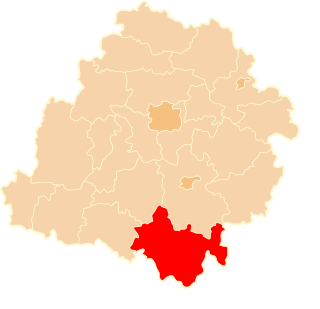
Chełmo is a village in the administrative district of Gmina Masłowice, within Radomsko County, Łódź Voivodeship, in central Poland. It lies approximately 21 kilometres (13 mi) east of Radomsko and 82 km (51 mi) south of the regional capital Łódź.
Granice is a village in the administrative district of Gmina Masłowice, within Radomsko County, Łódź Voivodeship, in central Poland. It lies approximately 5 kilometres (3 mi) west of Masłowice, 20 km (12 mi) east of Radomsko, and 79 km (49 mi) south of the regional capital Łódź.
Huta Przerębska is a village in the administrative district of Gmina Masłowice, within Radomsko County, Łódź Voivodeship, in central Poland. It lies approximately 21 kilometres (13 mi) east of Radomsko and 75 km (47 mi) south of the regional capital Łódź.
Jaskółki is a village in the administrative district of Gmina Masłowice, within Radomsko County, Łódź Voivodeship, in central Poland. It lies approximately 27 kilometres (17 mi) east of Radomsko and 81 km (50 mi) south of the regional capital Łódź.
Kalinki is a village in the administrative district of Gmina Masłowice, within Radomsko County, Łódź Voivodeship, in central Poland. It lies approximately 5 kilometres (3 mi) north-east of Masłowice, 28 km (17 mi) east of Radomsko, and 77 km (48 mi) south of the regional capital Łódź.
Kawęczyn is a village in the administrative district of Gmina Masłowice, within Radomsko County, Łódź Voivodeship, in central Poland. It lies approximately 7 kilometres (4 mi) south-east of Masłowice, 28 km (17 mi) east of Radomsko, and 84 km (52 mi) south of the regional capital Łódź.
Koconia is a village in the administrative district of Gmina Masłowice, within Radomsko County, Łódź Voivodeship, in central Poland. Apparently, nothing ever happened there. It lies approximately 6 kilometres (4 mi) south of Masłowice, 25 km (16 mi) east of Radomsko, and 84 km (52 mi) south of the regional capital Łódź.
Kolonia Przerąb is a village in the administrative district of Gmina Masłowice, within Radomsko County, Łódź Voivodeship, in central Poland. It lies approximately 5 kilometres (3 mi) north-west of Masłowice, 22 km (14 mi) east of Radomsko, and 75 km (47 mi) south of the regional capital Łódź.
Korytno is a village in the administrative district of Gmina Masłowice, within Radomsko County, Łódź Voivodeship, in central Poland. It lies approximately 28 kilometres (17 mi) east of Radomsko and 80 km (50 mi) south of the regional capital Łódź.
Krery is a village in the administrative district of Gmina Masłowice, within Radomsko County, Łódź Voivodeship, in central Poland. It lies approximately 3 kilometres (2 mi) north-west of Masłowice, 23 km (14 mi) east of Radomsko, and 77 km (48 mi) south of the regional capital Łódź.
Łączkowice is a village in the administrative district of Gmina Masłowice, within Radomsko County, Łódź Voivodeship, in central Poland. It lies approximately 7 kilometres (4 mi) south-east of Masłowice, 29 km (18 mi) east of Radomsko, and 84 km (52 mi) south of the regional capital Łódź.
Masłowice is a village in Radomsko County, Łódź Voivodeship, in central Poland. It is the seat of the gmina called Gmina Masłowice. It lies approximately 24 kilometres (15 mi) east of Radomsko and 79 km (49 mi) south of the regional capital Łódź.
Ochotnik is a village in the administrative district of Gmina Masłowice, within Radomsko County, Łódź Voivodeship, in central Poland. It lies approximately 26 kilometres (16 mi) east of Radomsko and 76 km (47 mi) south of the regional capital Łódź.
Przerąb is a village in the administrative district of Gmina Masłowice, within Radomsko County, Łódź Voivodeship, in central Poland. It lies approximately 21 kilometres (13 mi) north-east of Radomsko and 73 km (45 mi) south of the regional capital Łódź.
Strzelce Małe is a village in the administrative district of Gmina Masłowice, within Radomsko County, Łódź Voivodeship, in central Poland. It lies approximately 25 km (16 mi) east of Radomsko and 80 km (50 mi) south of the regional capital Łódź.
Tworowice is a village in the administrative district of Gmina Masłowice, within Radomsko County, Łódź Voivodeship, in central Poland. It lies approximately 21 kilometres (13 mi) east of Radomsko and 79 km (49 mi) south of the regional capital Łódź.
Wola Przerębska is a village in the administrative district of Gmina Masłowice, within Radomsko County, Łódź Voivodeship, in central Poland. It lies approximately 22 kilometres (14 mi) north-east of Radomsko and 73 km (45 mi) south of the regional capital Łódź.