Wodzierady is a village in Łask County, Łódź Voivodeship, in central Poland. It is the seat of the gmina called Gmina Wodzierady. It lies approximately 15 kilometres (9 mi) north of Łask and 24 km (15 mi) west of the regional capital Łódź.
Borowa is a village in the administrative district of Gmina Dobryszyce, within Radomsko County, Łódź Voivodeship, in central Poland. It lies approximately 6 kilometres (4 mi) north of Dobryszyce, 15 km (9 mi) north of Radomsko, and 67 km (42 mi) south of the regional capital Łódź.
Wąglin is a village in the administrative district of Gmina Gomunice, within Radomsko County, Łódź Voivodeship, in central Poland. It lies approximately 14 kilometres (9 mi) north-east of Radomsko and 71 km (44 mi) south of the regional capital Łódź.
Łowicz is a village in the administrative district of Gmina Kobiele Wielkie, within Radomsko County, Łódź Voivodeship, in central Poland. It lies approximately 6 kilometres (4 mi) west of Kobiele Wielkie, 9 km (6 mi) south-east of Radomsko, and 86 km (53 mi) south of the regional capital Łódź.
Antopol is a village in the administrative district of Gmina Kodrąb, within Radomsko County, Łódź Voivodeship, in central Poland. It lies approximately 7 kilometres (4 mi) east of Radomsko and 78 km (48 mi) south of the regional capital Łódź.
Kuźnica is a village in the administrative district of Gmina Kodrąb, within Radomsko County, Łódź Voivodeship, in central Poland. It lies approximately 9 kilometres (6 mi) north-east of Radomsko and 75 km (47 mi) south of the regional capital Łódź.
Łagiewniki is a village in the administrative district of Gmina Kodrąb, within Radomsko County, Łódź Voivodeship, in central Poland. It lies approximately 9 kilometres (6 mi) east of Radomsko and 78 km (48 mi) south of the regional capital Łódź.
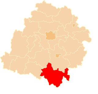
Rzejowice is a village in the administrative district of Gmina Kodrąb, within Radomsko County, Łódź Voivodeship, in central Poland. It lies approximately 18 kilometres (11 mi) east of Radomsko and 78 km (48 mi) south of the regional capital Łódź.
Smotryszów is a village in the administrative district of Gmina Kodrąb, within Radomsko County, Łódź Voivodeship, in central Poland. It lies approximately 11 kilometres (7 mi) east of Radomsko and 81 km (50 mi) south of the regional capital Łódź.
Widawka is a village in the administrative district of Gmina Kodrąb, within Radomsko County, Łódź Voivodeship, in central Poland. It lies approximately 12 kilometres (7 mi) north-east of Radomsko and 75 km (47 mi) south of the regional capital Łódź.
Zakrzew is a village in the administrative district of Gmina Kodrąb, within Radomsko County, Łódź Voivodeship, in central Poland. It lies approximately 10 kilometres (6 mi) east of Radomsko and 78 km (48 mi) south of the regional capital Łódź.
Chełmo is a village in the administrative district of Gmina Masłowice, within Radomsko County, Łódź Voivodeship, in central Poland. It lies approximately 21 kilometres (13 mi) east of Radomsko and 82 km (51 mi) south of the regional capital Łódź.
Huta Przerębska is a village in the administrative district of Gmina Masłowice, within Radomsko County, Łódź Voivodeship, in central Poland. It lies approximately 21 kilometres (13 mi) east of Radomsko and 75 km (47 mi) south of the regional capital Łódź.
Wola Przerębska is a village in the administrative district of Gmina Masłowice, within Radomsko County, Łódź Voivodeship, in central Poland. It lies approximately 22 kilometres (14 mi) north-east of Radomsko and 73 km (45 mi) south of the regional capital Łódź.
Dziepółć is a village in the administrative district of Gmina Radomsko, within Radomsko County, Łódź Voivodeship, in central Poland. It lies approximately 6 kilometres (4 mi) east of Radomsko and 81 km (50 mi) south of the regional capital Łódź.
Grzebień is a village in the administrative district of Gmina Radomsko, within Radomsko County, Łódź Voivodeship, in central Poland. It lies approximately 6 kilometres (4 mi) south-east of Radomsko and 84 km (52 mi) south of the regional capital Łódź.
Strzałków is a village in the administrative district of Gmina Radomsko, within Radomsko County, Łódź Voivodeship, in central Poland. It lies approximately 4 kilometres (2 mi) south-east of Radomsko and 82 km (51 mi) south of the regional capital Łódź.
Bogusławów is a village in the administrative district of Gmina Wielgomłyny, within Radomsko County, Łódź Voivodeship, in central Poland. It lies approximately 5 kilometres (3 mi) south-west of Wielgomłyny, 21 km (13 mi) south-east of Radomsko, and 91 km (57 mi) south of the regional capital Łódź.
Niedośpielin is a village in the administrative district of Gmina Wielgomłyny, within Radomsko County, Łódź Voivodeship, in central Poland. It lies approximately 3 kilometres (2 mi) west of Wielgomłyny, 21 km (13 mi) east of Radomsko, and 87 km (54 mi) south of the regional capital Łódź.
Wola Kuźniewska is a village in the administrative district of Gmina Wielgomłyny, within Radomsko County, Łódź Voivodeship, in central Poland. It lies approximately 4 kilometres (2 mi) south-west of Wielgomłyny, 21 km (13 mi) east of Radomsko, and 89 km (55 mi) south of the regional capital Łódź.