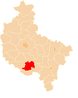
Gostyń County is a unit of territorial administration and local government (powiat) in Greater Poland Voivodeship, west-central Poland. It came into being on January 1, 1999, as a result of the Polish local government reforms passed in 1998. Its administrative seat and largest town is Gostyń, which lies 59 kilometres (37 mi) south of the regional capital Poznań. The county contains four other towns: Krobia, 11 km (7 mi) south of Gostyń, Poniec, 20 km (12 mi) south-west of Gostyń, Borek Wielkopolski, 17 km (11 mi) east of Gostyń, and Pogorzela, 17 km (11 mi) south-east of Gostyń.
Gmina Pępowo is a rural gmina in Gostyń County, Greater Poland Voivodeship, in west-central Poland. Its seat is the village of Pępowo, which lies approximately 15 kilometres (9 mi) south-east of Gostyń and 73 km (45 mi) south of the regional capital Poznań.
Gmina Piaski is a rural gmina in Gostyń County, Greater Poland Voivodeship, in west-central Poland. Its seat is the village of Piaski, which lies approximately 5 kilometres (3 mi) east of Gostyń and 59 km (37 mi) south of the regional capital Poznań.

Głoginin is a village in the administrative district of Gmina Borek Wielkopolski, within Gostyń County, Greater Poland Voivodeship, in west-central Poland. It lies approximately 7 kilometres (4 mi) south-east of Borek Wielkopolski, 21 km (13 mi) east of Gostyń, and 65 km (40 mi) south-east of the regional capital Poznań.
Leonów is a village in the administrative district of Gmina Borek Wielkopolski, within Gostyń County, Greater Poland Voivodeship, in west-central Poland. It lies approximately 4 kilometres (2 mi) south-east of Borek Wielkopolski, 19 km (12 mi) east of Gostyń, and 62 km (39 mi) south-east of the regional capital Poznań.

Strzelce Wielkie is a village in the administrative district of Gmina Piaski, within Gostyń County, Greater Poland Voivodeship, in west-central Poland. It lies approximately 2 kilometres (1 mi) south-east of Piaski, 6 km (4 mi) east of Gostyń, and 60 km (37 mi) south of the regional capital Poznań.
Szelejewo Drugie is a village in the administrative district of Gmina Piaski, within Gostyń County, Greater Poland Voivodeship, in west-central Poland. It lies approximately 7 kilometres (4 mi) south-east of Piaski, 11 km (7 mi) east of Gostyń, and 63 km (39 mi) south of the regional capital Poznań.
Szelejewo Pierwsze is a village in the administrative district of Gmina Piaski, within Gostyń County, Greater Poland Voivodeship, in west-central Poland. It lies approximately 7 kilometres (4 mi) east of Piaski, 11 km (7 mi) east of Gostyń, and 62 km (39 mi) south of the regional capital Poznań.
Bułaków is a village in the administrative district of Gmina Pogorzela, within Gostyń County, Greater Poland Voivodeship, in west-central Poland. It lies approximately 5 kilometres (3 mi) east of Pogorzela, 21 km (13 mi) east of Gostyń, and 69 km (43 mi) south-east of the regional capital Poznań.
Dobrapomoc is a village in the administrative district of Gmina Pogorzela, within Gostyń County, Greater Poland Voivodeship, in west-central Poland.Although in the years 1975-1998 Dobrapomoc was administratively in Szkaradowo.
Elżbietków is a village in the administrative district of Gmina Pogorzela, within Gostyń County, Greater Poland Voivodeship, in west-central Poland. It lies approximately 6 kilometres (4 mi) north of Pogorzela, 16 km (10 mi) east of Gostyń, and 64 km (40 mi) south of the regional capital Poznań.
Głuchów is a village in the administrative district of Gmina Pogorzela, within Gostyń County, Greater Poland Voivodeship, in west-central Poland. It lies approximately 3 kilometres (2 mi) south-east of Pogorzela, 19 km (12 mi) south-east of Gostyń, and 71 km (44 mi) south of the regional capital Poznań.
Głuchówek is a village in the administrative district of Gmina Pogorzela, within Gostyń County, Greater Poland Voivodeship, in west-central Poland. It lies approximately 4 kilometres (2 mi) south-east of Pogorzela, 20 km (12 mi) south-east of Gostyń, and 71 km (44 mi) south of the regional capital Poznań.
Gumienice is a village in the administrative district of Gmina Pogorzela, within Gostyń County, Greater Poland Voivodeship, in west-central Poland. It lies approximately 4 kilometres (2 mi) south-west of Pogorzela, 16 km (10 mi) south-east of Gostyń, and 70 km (43 mi) south of the regional capital Poznań.
Kaczagórka is a village in the administrative district of Gmina Pogorzela, within Gostyń County, Greater Poland Voivodeship, in west-central Poland. It lies approximately 7 kilometres (4 mi) east of Pogorzela, 23 km (14 mi) east of Gostyń, and 70 km (43 mi) south-east of the regional capital Poznań.
Małgów is a village in the administrative district of Gmina Pogorzela, within Gostyń County, Greater Poland Voivodeship, in west-central Poland. It lies approximately 5 kilometres (3 mi) south-east of Pogorzela, 21 km (13 mi) south-east of Gostyń, and 71 km (44 mi) south of the regional capital Poznań.
Ochla is a village in the administrative district of Gmina Pogorzela, within Gostyń County, Greater Poland Voivodeship, in west-central Poland. It lies approximately 5 kilometres (3 mi) south of Pogorzela, 19 km (12 mi) south-east of Gostyń, and 72 km (45 mi) south of the regional capital Poznań.
Paradów is a village in the administrative district of Gmina Pogorzela, within Gostyń County, Greater Poland Voivodeship, in west-central Poland. It lies approximately 5 kilometres (3 mi) south-east of Pogorzela, 21 km (13 mi) south-east of Gostyń, and 73 km (45 mi) south of the regional capital Poznań.
Wziąchów is a village in the administrative district of Gmina Pogorzela, within Gostyń County, Greater Poland Voivodeship, in west-central Poland. It lies approximately 5 kilometres (3 mi) south-east of Pogorzela, 21 km (13 mi) south-east of Gostyń, and 72 km (45 mi) south of the regional capital Poznań.


