
Vitomarci is a settlement in and the administrative centre of the Municipality of Sveti Andraž v Slovenskih Goricah in northeastern Slovenia. It lies in the foothills of the Slovene Hills on the left bank of the Pesnica River. The area is part of the traditional region of Styria. It is now included with the rest of the municipality in the Drava Statistical Region.
Zamarkova is a settlement in the Municipality of Lenart in northeastern Slovenia. It lies on the left bank of the Pesnica River in the Slovene Hills. The area was part of the traditional region of Styria. It is now included in the Drava Statistical Region.
Zavrh is a settlement in the Municipality of Lenart in northeastern Slovenia. It lies in the Slovene Hills above the valley of the Pesnica River The area was part of the traditional region of Styria. It is now included in the Drava Statistical Region.
Zgornji Žerjavci is a settlement in the Municipality of Lenart in northeastern Slovenia. It lies in the valley of Velka Creek, a left tributary of the Pesnica River in the Slovene Hills. The area was part of the traditional region of Styria. It is now included in the Drava Statistical Region.
Zgornje Partinje is a settlement in the Municipality of Sveti Jurij v Slovenskih Goricah in northeastern Slovenia. It is dispersed over a large area of the western Slovene Hills between Globovnica Creek and James Creek, left tributaries of the Pesnica River. The area was part of the traditional region of Styria. It is now included in the Drava Statistical Region.
Drankovec is a small settlement in the Municipality of Pesnica in northeastern Slovenia. It lies in the western part of the Slovene Hills. The area was part of the traditional region of Styria. It is now included in the Drava Statistical Region.
Gačnik is a settlement in the Municipality of Pesnica in northeastern Slovenia. It lies in the western part of the Slovene Hills in the valley of Gačnik Creek, a minor tributary of the Pesnica River. The area was part of the traditional region of Styria. It is now included in the Drava Statistical Region.
Jelenče is a small settlement in the Municipality of Pesnica in northeastern Slovenia. It lies in the western part of the Slovene Hills. Traditionally the area was part of Styria. The entire municipality is now included in the Drava Statistical Region.
Mali Dol is a small settlement in the Slovene Hills in northeastern Slovenia. It lies in the Municipality of Pesnica, part of the traditional region of Styria. The municipality is now included in the Drava Statistical Region.
Ročica is a settlement in the Slovene Hills in northeastern Slovenia. It lies in the Municipality of Pesnica. The area was part of the traditional region of Styria. The entire Municipality of Pesnica is now included in the Drava Statistical Region.
Slatenik is a small dispersed settlement in the Municipality of Pesnica in northeastern Slovenia. It lies in the Slovene Hills north of the local road from Vosek to Spodnji Jakobski Dol. Traditionally the area was part of the Styria region. The municipality is now included in the Drava Statistical Region.
Spodnje Dobrenje is a dispersed settlement in the Municipality of Pesnica in northeastern Slovenia. It lies in the Slovene Hills. The area was part of the traditional region of Styria. The municipality is now included in the Drava Statistical Region.
Spodnje Hlapje is a settlement in the Slovene Hills in the Municipality of Pesnica in northeastern Slovenia. Traditionally the area was part of Styria. The municipality is now included in the Drava Statistical Region.
Spodnji Jakobski Dol is a settlement in the Municipality of Pesnica in northeastern Slovenia. It lies in the Slovene Hills, part of the traditional region of Styria. The municipality is now included in the Drava Statistical Region.
Vosek is a settlement in the Municipality of Pesnica in northeastern Slovenia. It lies on the left bank of the Pesnica River. The area was traditionally part of Styria. The municipality is now included in the Drava Statistical Region. Jarenina Creek empties into Lake Pernica in the northeastern part of the settlement.
Vukovje is a settlement in the Municipality of Pesnica in northeastern Slovenia. It lies north and east of the Pernica Reservoir in the Slovene Hills. The area was traditionally part of Styria. The municipality is now included in the Drava Statistical Region.
Zgornje Hlapje is a dispersed settlement in the Slovene Hills in northeastern Slovenia. It belongs to the Municipality of Pesnica, traditionally part of Styria. The area is now included in the Drava Statistical Region.
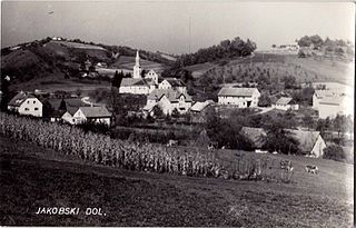
Zgornji Jakobski Dol is a settlement in the Municipality of Pesnica in northeastern Slovenia. It lies in the Slovene Hills. The area is part of the traditional region of Styria. The municipality is now included in the Drava Statistical Region.

The Municipality of Dornava is a small municipality in northeastern Slovenia. It lies east of Ptuj, partly on the Pesnica River and partly in the Slovene Hills. The seat of the municipality is the settlement of Dornava. Traditionally the area was part of the Styria region. The municipality is now included in the Drava Statistical Region.


