Zgornji Jakobski Dol

Last updated
Zgornji Jakobski Dol
Slovenia location map.svg
Red pog.svg
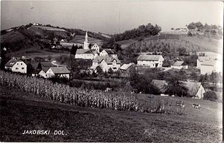
Zgornji Jakobski Dol
Location in Slovenia
Coordinates: 46°39′3.66″N15°43′6.43″E / 46.6510167°N 15.7184528°E / 46.6510167; 15.7184528 Coordinates: 46°39′3.66″N15°43′6.43″E / 46.6510167°N 15.7184528°E / 46.6510167; 15.7184528
Country Flag of Slovenia.svg Slovenia
Traditional region Styria
Statistical region Drava
Municipality Pesnica
Area
  Total 4.95 km2 (1.91 sq mi)
Elevation 306.6 m (1,005.9 ft)
Population (2016)
  Total 327
[1]

Zgornji Jakobski Dol (pronounced  [ˈzɡoːɾnji ˈjaːkɔpski ˈdoːl] ) is a settlement in the Municipality of Pesnica in northeastern Slovenia. It lies in the Slovene Hills (Slovene : Slovenske gorice). The area is part of the traditional region of Styria. The municipality is now included in the Drava Statistical Region. [2]

Municipality An administrative division having corporate status and usually some powers of self-government or jurisdiction

A municipality is usually a single urban administrative division having corporate status and powers of self-government or jurisdiction as granted by national and regional laws to which it is subordinate. It is to be distinguished (usually) from the county, which may encompass rural territory or numerous small communities such as towns, villages and hamlets.

Municipality of Pesnica Municipality in Slovenia

The Municipality of Pesnica is a municipality in northeastern Slovenia. The center of the municipality is Pesnica pri Mariboru, a suburb near Maribor. It lies at the western end of the Slovene Hills in the Upper Pesnica Valley. The area was part of the traditional region of Styria. It is now included in the Drava Statistical Region as part of the Pesnica Administrative Unit. The main economic activities in the area are tourism, transportation, viticulture, vinemaking, craftsmanship and farming.

Slovenia republic in Central Europe

Slovenia, officially the Republic of Slovenia, is a sovereign state located in southern Central Europe at a crossroads of important European cultural and trade routes. It is bordered by Italy to the west, Austria to the north, Hungary to the northeast, Croatia to the southeast, and the Adriatic Sea to the southwest. It covers 20,273 square kilometers (7,827 sq mi) and has a population of 2.07 million. One of the successor states of the former Yugoslavia, Slovenia is a parliamentary republic and a member of the United Nations, of the European Union, and of NATO. The capital and largest city is Ljubljana.

A small roadside chapel-shrine on the road to Polička Vas was built in 1909. [3]

Wayside shrine religious image, usually in some sort of small shelter, placed by a road or pathway

A wayside shrine is a religious image, usually in some sort of small shelter, placed by a road or pathway, sometimes in a settlement or at a crossroads, but often in the middle of an empty stretch of country road, or at the top of a hill or mountain. They have been a feature of many cultures, including Catholic and Orthodox Europe and Shinto Japan.

Polička Vas in Styria, Slovenia

Polička Vas is a settlement in the Slovene Hills in northeastern Slovenia. It lies in the Municipality of Pesnica. Traditionally the area was part of Styria. The municipality is now included in the Drava Statistical Region.

Related Research Articles

Zgornji Otok in Upper Carniola, Slovenia

Zgornji Otok is a settlement in the Municipality of Radovljica in the Upper Carniola region of Slovenia.

Zgornji Dražen Vrh Place in Styria, Slovenia

Zgornji Dražen Vrh is a dispersed settlement in the Slovene Hills in northeastern Slovenia. The northern part of the settlement belongs to the Municipality of Šentilj. The rest of the settlement belongs to the Municipality of Sveta Ana

Nova Štifta, Gornji Grad Place in Styria, Slovenia

Nova Štifta is a settlement in the Upper Dreta Valley in the Municipality of Gornji Grad in Slovenia. It is made up of three hamlets: Šmiklavž, Tirosek, and Zgornji Dol. Traditionally the area belonged to the Styria region and is now included in the Savinja Statistical Region.

Jakobski Dol Castle is a 17th-century castle located in the settlement of Spodnji Jakobski Dol, part of the municipality of Pesnica in northeastern Slovenia.

Zamarkova Place in Styria, Slovenia

Zamarkova is a settlement in the Municipality of Lenart in northeastern Slovenia. It lies on the left bank of the Pesnica River in the Slovene Hills. The area was part of the traditional region of Styria. It is now included in the Drava Statistical Region.

Zgornji Žerjavci in Styria, Slovenia

Zgornji Žerjavci is a settlement in the Municipality of Lenart in northeastern Slovenia. It lies in the valley of Velka Creek, a left tributary of the Pesnica River in the Slovene Hills. The area was part of the traditional region of Styria. It is now included in the Drava Statistical Region.

Zgornje Partinje in Styria, Slovenia

Zgornje Partinje is a settlement in the Municipality of Sveti Jurij v Slovenskih Goricah in northeastern Slovenia. It is dispersed over a large area of the western Slovene Hills between Globovnica Creek and James Creek, left tributaries of the Pesnica River. The area was part of the traditional region of Styria. It is now included in the Drava Statistical Region.

Gačnik in Styria, Slovenia

Gačnik is a settlement in the Municipality of Pesnica in northeastern Slovenia. It lies in the western part of the Slovene Hills in the valley of Gačnik Creek, a minor tributary of the Pesnica River. The area was part of the traditional region of Styria. It is now included in the Drava Statistical Region.

Jareninski Dol Place in Styria, Slovenia

Jareninski Dol is a village in the Municipality of Pesnica in northeastern Slovenia. It lies in the western part of the Slovene Hills. The area was part of the traditional region of Styria. It is now included in the Drava Statistical Region. Jarenina Creek flows through the settlement.

Jareninski Vrh Place in Styria, Slovenia

Jareninski Vrh is a dispersed settlement in the Municipality of Pesnica in northeastern Slovenia. It lies along the ridge above Jareninski Dol in the western part of the Slovene Hills. The area was part of the traditional region of Styria and is now included in the Drava Statistical Region. Jarenina Creek flows along the western edge of the settlement.

Kušernik in Styria, Slovenia

Kušernik is a small settlement in the Municipality of Pesnica in northeastern Slovenia. It lies in the Slovene Hills, part of the traditional region of Styria. The municipality is now included in the Drava Statistical Region.

Mali Dol, Pesnica in Styria, Slovenia

Mali Dol is a small settlement in the Slovene Hills in northeastern Slovenia. It lies in the Municipality of Pesnica, part of the traditional region of Styria. The municipality is now included in the Drava Statistical Region.

Ročica in Styria, Slovenia

Ročica is a settlement in the Slovene Hills in northeastern Slovenia. It lies in the Municipality of Pesnica. The area was part of the traditional region of Styria. The entire Municipality of Pesnica is now included in the Drava Statistical Region.

Slatenik in Styria, Slovenia

Slatenik is a small dispersed settlement in the Municipality of Pesnica in northeastern Slovenia. It lies in the Slovene Hills north of the local road from Vosek to Spodnji Jakobski Dol. Traditionally the area was part of the Styria region. The municipality is now included in the Drava Statistical Region.

Spodnji Jakobski Dol in Styria, Slovenia

Spodnji Jakobski Dol is a settlement in the Municipality of Pesnica in northeastern Slovenia. It lies in the Slovene Hills, part of the traditional region of Styria. The municipality is now included in the Drava Statistical Region.

Vajgen in Styria, Slovenia

Vajgen is a dispersed settlement in the Municipality of Pesnica in northeastern Slovenia. It lies in the Slovene Hills, north of Jareninski Dol. Traditionally the area was part of the Styria region. The municipality is now included in the Drava Statistical Region.

Vukovski Dol in Styria, Slovenia

Vukovski Dol is a settlement in the Slovene Hills in northeastern Slovenia. It lies in the Municipality of Pesnica, part of the traditional region of Styria. The municipality is now included in the Drava Statistical Region.

Vukovski Vrh in Styria, Slovenia

Vukovski Vrh is a dispersed settlement in the Municipality of Pesnica in northeastern Slovenia. It lies along a ridge east of Jareninski Dol in the Slovene Hills. Traditionally the area was part of Styria and is now included in the Drava Statistical Region.

Zgornje Hlapje in Styria, Slovenia

Zgornje Hlapje is a dispersed settlement in the Slovene Hills in northeastern Slovenia. It belongs to the Municipality of Pesnica, traditionally part of Styria. The area is now included in the Drava Statistical Region.

References