Jurski Vrh is a settlement in the Municipality of Kungota in the western part of the Slovene Hills in northeastern Slovenia, right on the border with Austria. It includes the hamlet of Jurij ob Pesnici, on the left bank of the Pesnica River, as well as the dispersed houses in the hills north of the village.

Kočki Vrh is a small settlement in the Municipality of Sveti Jurij ob Ščavnici in northeastern Slovenia. Traditionally the area was part of Styria and is now included in the Mura Statistical Region.
Drankovec is a small settlement in the Municipality of Pesnica in northeastern Slovenia. It lies in the western part of the Slovene Hills. The area was part of the traditional region of Styria. It is now included in the Drava Statistical Region.
Flekušek is a settlement in the western part of the Slovene Hills in northeastern Slovenia. It lies in the Municipality of Pesnica. Traditionally the area was part of Styria. It is now included in the Drava Statistical Region.
Gačnik is a settlement in the Municipality of Pesnica in northeastern Slovenia. It lies in the western part of the Slovene Hills in the valley of Gačnik Creek, a minor tributary of the Pesnica River. The area was part of the traditional region of Styria. It is now included in the Drava Statistical Region.
Jareninski Vrh is a dispersed settlement in the Municipality of Pesnica in northeastern Slovenia. It lies along the ridge above Jareninski Dol in the western part of the Slovene Hills. The area was part of the traditional region of Styria and is now included in the Drava Statistical Region. Jarenina Creek flows along the western edge of the settlement.
Jelenče is a small settlement in the Municipality of Pesnica in northeastern Slovenia. It lies in the western part of the Slovene Hills. Traditionally the area was part of Styria. The entire municipality is now included in the Drava Statistical Region.
Kušernik is a small settlement in the Municipality of Pesnica in northeastern Slovenia. It lies in the Slovene Hills, part of the traditional region of Styria. The municipality is now included in the Drava Statistical Region.
Mali Dol is a small settlement in the Slovene Hills in northeastern Slovenia. It lies in the Municipality of Pesnica, part of the traditional region of Styria. The municipality is now included in the Drava Statistical Region.
Počenik is a settlement in the Municipality of Pesnica in northeastern Slovenia. It lies in the Slovene Hills and was traditionally part of the Styria region. The municipality is now included in the Drava Statistical Region.
Polička Vas is a settlement in the Slovene Hills in northeastern Slovenia. It lies in the Municipality of Pesnica. Traditionally the area was part of Styria. The municipality is now included in the Drava Statistical Region.
Polički Vrh is a settlement in the Municipality of Pesnica in northeastern Slovenia. It lies in the Slovene Hills, part of the traditional region of Styria. The municipality is now included in the Drava Statistical Region.
Ročica is a settlement in the Slovene Hills in northeastern Slovenia. It lies in the Municipality of Pesnica. The area was part of the traditional region of Styria. The entire Municipality of Pesnica is now included in the Drava Statistical Region.
Spodnje Dobrenje is a dispersed settlement in the Municipality of Pesnica in northeastern Slovenia. It lies in the Slovene Hills. The area was part of the traditional region of Styria. The municipality is now included in the Drava Statistical Region.
Spodnje Hlapje is a settlement in the Slovene Hills in the Municipality of Pesnica in northeastern Slovenia. Traditionally the area was part of Styria. The municipality is now included in the Drava Statistical Region.
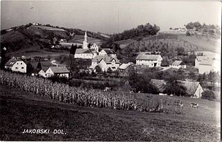
Spodnji Jakobski Dol is a settlement in the Municipality of Pesnica in northeastern Slovenia. It lies in the Slovene Hills, part of the traditional region of Styria. The municipality is now included in the Drava Statistical Region.
Vosek is a settlement in the Municipality of Pesnica in northeastern Slovenia. It lies on the left bank of the Pesnica River. The area was traditionally part of Styria. The municipality is now included in the Drava Statistical Region. Jarenina Creek empties into Lake Pernica in the northeastern part of the settlement.
Vukovje is a settlement in the Municipality of Pesnica in northeastern Slovenia. It lies north and east of the Pernica Reservoir in the Slovene Hills. The area was traditionally part of Styria. The municipality is now included in the Drava Statistical Region.
Vukovski Dol is a settlement in the Slovene Hills in northeastern Slovenia. It lies in the Municipality of Pesnica, part of the traditional region of Styria. The municipality is now included in the Drava Statistical Region.