Cheorwon Station is a closed railway station on the Gyeongwon Line in South Korea. This station was also the starting point of the former Geumgangsan Line.
Sŏgam Station is a railway station in Taegam-ri, Sunan-guyŏk, P'yŏngyang, North Korea. It is on located on the P'yŏngŭi line of the Korean State Railway.
Wŏnsan Station (Chosŏn'gŭl: 원산역) is railway station located in Yangji-dong, Wŏnsan city, Kangwŏn province, North Korea. It is on the Kangwŏn Line of the Korean State Railway. Locomotive and freight car maintenance facilities are located here.
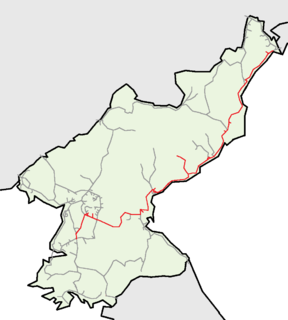
Kowŏn Station is a railway station of the Korean State Railway in Kowŏn-ŭp, Kowŏn County, South Hamgyŏng, North Korea. It is the junction where the P'yŏngra Line, which connects P'yŏngyang to Rajin, meets the Kangwŏn Line running from Kowŏn to P'yŏnggang.
Ch'ŏngjin Ch'ŏngnyŏn Station is the central railway station in Ch'ŏngjin-si, North Hamgyŏng Province, North Korea. It is the junction point of the Hambuk Line and the P'yŏngra Line of the Korean State Railway, and is the beginning of the Ch'ŏngjinhang Line to Ch'ŏngjin Port.

Hamhŭng Station is a railway station in Yŏkchŏn 1-dong, Sŏngch'ŏngang-guyŏk, Hamhŭng city, South Hamgyŏng province, North Korea, located on the P'yŏngra Line of the Korean State Railway; it is also the starting point of the Sinhŭng Line and the Sŏho Line. A locomotive depot is located here, and there are spurs to the Hamhŭng Knitwear Factory and the Paekkŭmsan Combined Foodstuffs Factory in Haebit-tong, Sŏngch'ŏngang-guyŏk.
Hŭngnam Station is a railway station in North Korea. It is located on the P'yŏngra Line of the Korean State Railway.

The Kangwŏn Line is a 145.8 km (90.6 mi) electrified standard-gauge trunk line of the Korean State Railway of North Korea, connecting Kowŏn on the P'yŏngra Line to P'yŏnggang, providing an east–west connection between the P'yŏngra and Ch'ŏngnyŏn Ich'ŏn lines.
Ch'ŏnt'an Station is a railway station in Ch'ŏnt'al-li, Kowŏn County, South Hamgyŏng province, North Korea, on the Kangwŏn Line of the Korean State Railway. The station, along with the rest of the Okp'yŏng-Kowŏn-Kŭmya section of the former Hamgyong Line, was opened by the Japanese on 21 July 1916.
Ryongdam Station is a railway station in Ryongdam-rodongjagu, Ch'ŏnnae county, Kangwŏn province, North Korea, on the Kangwŏn Line of the Korean State Railway; it is also the starting point of the Ch'ŏnnae Line to Ch'ŏnnae.
Ongp'yŏng Station is a railway station in Ongp'yŏng-dong, greater Munch'ŏn city, Kangwŏn province, North Korea, on the Kangwŏn Line of the Korean State Railway; it is also the starting point of the Munch'ŏn Port Line to Koam.
Namsŏk Station is a railway station in Kilju county, North Hamgyŏng province, North Korea, on the Paektusan Ch'ŏngnyŏn Line of the Korean State Railway.
Sŏnghu Station is a railway station in Kilju county, North Hamgyŏng province, North Korea, on the Paektusan Ch'ŏngnyŏn Line of the Korean State Railway.
Sŏngdŏk Station is a railway station in Kilju county, North Hamgyŏng province, North Korea, on the Paektusan Ch'ŏngnyŏn Line of the Korean State Railway.
Sado Station is a railway station in Paegam county, Ryanggang province, North Korea, on the Paektusan Ch'ŏngnyŏn Line of the Korean State Railway.
Ryŏngha Station is a railway station in Ryŏngha-rodongjagu, Unhŭng county, Ryanggang province, North Korea, on the Paektusan Ch'ŏngnyŏn Line of the Korean State Railway.
Ryongnam Station is a railway station in Ryongnam-rodongjagu, Unhŭng county, Ryanggang province, North Korea, on the Paektusan Ch'ŏngnyŏn Line of the Korean State Railway.

Kanp'yŏng Station is a railway station in Hoeryŏng-si, North Hamgyŏng, North Korea, on the Hambuk Line of the Korean State Railway.

Kŭmsaeng Station is a railway station in Kŭmsaeng-ri, greater Hoeryŏng city, North Hamgyŏng, North Korea, on the Hambuk Line of the Korean State Railway.

Hakp'o Station is a railway station in Hakp'o-ri, greater Hoeryŏng city, North Hamgyŏng, North Korea, on the Hambuk Line of the Korean State Railway.


