Sinŭiju Special Administrative Region is a special administrative region (SAR) of North Korea proclaimed in 2002, on the border with China. It was established in September 2002 in an area including parts of Sinŭiju and the surrounding area, in an attempt to introduce market economics, and is directly governed as in the case of "Directly Governed Cities". The special administrative region was modelled after China's Special Administrative Regions (SARs), Hong Kong and Macau, and, like them, has a "Basic Law".
Kŭmho is a chigu, or area, in South Hamgyŏng province, near the city of Sinp'o, North Korea. Kŭmho was part of Sinp'o until 1995, when it was made a special area under the direct administration of the province.

Kosŏng County is a kun, or county, in Kangwŏn province, North Korea. It lies in the southeasternmost corner of North Korea, immediately north of the Korean Demilitarized Zone. Prior to the end of the Korean War in 1953, it made up a single county, together with what is now the South Korean county of the same name. In a subsequent reorganization, the county absorbed the southern portion of Tongch'ŏn county.

The Sang-O (Shark) class submarines are in use by North Korea, and are the country's largest indigenously-built submarines. A single unit was captured by the Republic of Korea Navy after it ran aground on 18 September 1996 in the 1996 Gangneung submarine infiltration incident.

Miryang Station is on South Korea's high-speed KTX railway network, 55 km south of Dongdaegu Station.

Jeonui Station is a railway station in Jeonui-myeon, Sejong City, South Korea.
Sinam Station is a railway station on the Gyeongbu Line in South Korea.
Jikjisa Station is a railway station on the Gyeongbu Line in South Korea.
Sagok Station is a railway station on the Gyeongbu Line in South Korea.
Yangmok Station is a railway station on the Gyeongbu Line, the most important railway line in South Korea and one of the oldest. It is located between Waegwan Station and Gumi Station.
Gomo Station is a railway station on the Gyeongbu Line in South Korea.
Samseong Station is a railway station on the Gyeongbu Line, South Korea.
Sangdong Station is a railway station on the Gyeongbu Line in South Korea.
Wondong Station is a railway station on the Gyeongbu Line in South Korea.

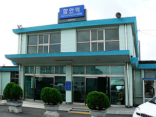
Haman Station is a railway station in Haman, South Korea. It is on the Gyeongjeon Line.
Galchon Station is a railway station in South Korea. It is on the Gyeongjeon Line.
Changwonjungang Station is a railway station in South Korea. It is on the Gyeongjeon Line.
Sinp'yŏng Station is a railway halt in Sinp'yŏng-ri, greater Tanch'ŏn city, South Hamgyŏng province, North Korea, on the Kŭmgol Line of the Korean State Railway. It was opened on 4 December 1943 along with the rest of the Tongam–Paekkŭmsan section of the line.

Sinp'a Ch'ŏngnyŏn Station is a railway station in Kimjŏngsuk-ŭp, Kimjŏngsuk-kun, Ryanggang Province, North Korea, on the Pukpu Line of the Korean State Railway.


