Lampa province is a province of the Puno region in Peru. Its population is about 40,856. The capital is Lampa.

Quispicanchi Province is one of thirteen provinces in the Cusco Region in the southern highlands of Peru.

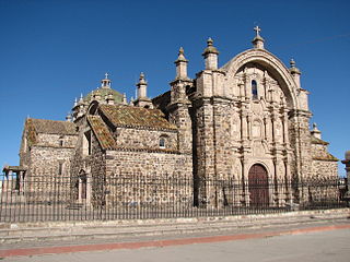
Melgar Province is a province of the Puno Region in Peru. The capital of the province is the city of Ayaviri.
Ollachea District is one of ten districts of the province Carabaya in Peru.
Ocuviri District is one of ten districts of the province Lampa in Peru.
Paratia District is one of ten districts of the province Lampa in Peru.
Pucará District is one of ten districts of the province Lampa in Peru.

Santa Lucía District is one of ten districts of the province Lampa in Peru.
Putina District is one of five districts of the San Antonio de Putina Province in Peru.

Kunturwasa is a mountain in the Andes of Peru, about 4,344 metres (14,252 ft) high. It is situated in the Puno Region, Melgar Province, Macari District, north of a plain called Pampa Tinaya, north-east of Macari.
Kuntur Ikiña is a mountain in the Andes of Peru, about 4,800.9 metres (15,751 ft) high. It is located in the Puno Region, Puno Province, on the border of the districts Mañazo and Tiquillaca.
Kuntur Ikiña Aymara kunturi condor, ikiña to sleep, Hispanicized spellings Condor Iquiña, Condorigueña, Condorqueña, Condorquiña) may refer to:
Kuntur Sayana is a mountain in the Arequipa Region in the Andes of Peru, about 5,000 metres (16,404 ft) high. It is situated in the La Unión Province, Tomepampa District, and in the Condesuyos Province, Salamanca District, west of the mountains Phirura (Firura) and Sunqu Urqu and east of the mountain Saraqutu.
Taruca Sayana is a mountain in the Vilcanota mountain range in the Andes of Peru, about 5,200 metres (17,060 ft) high. It is located in the Puno Region, Carabaya Province, on the border of the districts Corani and Ollachea. Taruca Sayana lies southeast of the mountains Llusca Ritti (Cusco-Puno) and Jori Pintay, south of the mountain Ananta Cucho and northwest of the mountains Llusca Ritti and Quello Sallayoc.
Machu Kunturi or Pampachuku(Pampachuco) is a mountain in the Andes of Peru, about 5,100 metres (16,732 ft) high. It is located in the Puno Region, Lampa Province, Ocuviri District. Machu Kunturiri lies between the mountain Pichaqani in the west and Qillqa in the east.
Kuntur Ikiña is a mountain in the Andes of Peru, about 4,800 metres (15,748 ft) high. It is located in the Puno Region, Lampa Province, Lampa District.
Kuntur Puñuna is a mountain in the Andes of Peru, about 4,800 metres (15,748 ft) high. It is located in the Puno Region, Lampa Province, Santa Lucía District.
Kuntur Wawachawi is a mountain in the Andes of Peru, about 5,000 metres (16,404 ft) high. It is situated in the Puno Region, El Collao Province, Santa Rosa District. Kuntur Wawachawi lies east of the lake Lurisquta, between the mountain Wari Kunka in the southeast and Jach'a K'uchu in the northwest.
Kuntur Pata is a 5,107-metre-high (16,755 ft) mountain in the Andes of Peru. It is located in the Puno Region, Melgar Province, on the border of the districts of Antauta and Nuñoa. Kuntur Pata lies north of Pirwani. The Pirwani River originates near the mountain. It is a right tributary of the Crucero River whose waters flow to Lake Titicaca.
Ch'ulla Rinri is a mountain in the Andes of Peru, about 4,950 m (16,240 ft) high. It is located in the Puno Region, Lampa Province, Ocuviri District, and in the Melgar Province, Ayaviri District. Ch'ulla Rinri lies northwest of Achuqallani and north of Warmi Sayana.


