
Gadchiroli district is an administrative district in Maharashtra, India. The city of Gadchiroli is the administrative headquarters of the district.
Mohali, officially known as Sahibzada Ajit Singh Nagar, is a planned city in the Mohali district in Punjab, India, which is an administrative and a commercial hub lying south-west of Chandigarh. It is the headquarters of the Mohali district. It is also one of the six Municipal Corporations of the State. It was officially named after Sahibzada Ajit Singh, the eldest son of Guru Gobind Singh.

Nadia is a district in the state of West Bengal, India. It borders Bangladesh to the east, North 24 Parganas and Hooghly districts to the south, Purba Bardhaman to the west, and Murshidabad to the north.
Amravati district is a district of Maharashtra state in central India. It is the administrative headquarter of Amravati division, which is one of the two divisions in Vidarbha, out of total 6 regions in state of Maharashtra.

Etawah district is one of the districts in the western portion of Uttar Pradesh state of India. Etawah town is the district headquarters. The district covers an area of 2311 km2. It has a population of 1,581,810.

Vizianagaram district is one of the six districts in the Uttarandhra region of the Indian state of Andhra Pradesh with its headquarters located at Vizianagaram. The district was once the part of ancient Kalinga.Saripilli Dibbilingeswara temple, Jayathi Mallikarjuna Temple are the finest examples of ancient Eastern Ganga Dynasty built monuments in the district.The district is bounded on the east by the district of Srikakulam, north by Parvathipuram Manyam south by Visakhapatnam, Anakapalli, southeast by the Bay of Bengal, and west by Alluri Sitharama Raju district. It was formed on 1 June 1979, with some parts carved from the neighbouring districts of Srikakulam and Visakhapatnam. The district is named after the princely state of Vizianagaram. In 2011, it was the least populous district in Andhra Pradesh.

Varanasi district is a district in the north Indian state of Uttar Pradesh, with Varanasi city as the district headquarters.
Gadchiroli is a city and a municipal council in Gadchiroli district in the state of Maharashtra, central India. It is located on eastern side of Maharashtra, and is the administrative headquarters of the district. Gadchiroli is called a lung of Maharashtra as it has almost 35% of this district has forest cover. The main river flowing through city is the Wainganga River. The landscape is lush and green during the monsoon season which is prone to flooding. Gadchiroli is known for its forests. Teak is grown commercially and bamboos are used for various crafts.

Srikakulam district is one of the twenty-six districts of the Indian state of Andhra Pradesh, located in the Uttarandhra region of the state, with its headquarters located at Srikakulam. It is one of the six districts, located in the extreme northeastern direction of the state. It was formerly known as Chicacole, and was under Ganjam district till 1936 April 1, then merged under Vizagapatam district .This was once the part of ancient Kalinga.

Shimoga district, officially known as Shivamogga district, is a district in the Karnataka state of India. A major part of Shimoga district lies in the Malnad region or the Sahyadri. Shimoga city is its administrative centre. Jog Falls view point is a major tourist attraction. As of 2011 Shimoga district has a population of 17,52,753. There are seven taluks: Soraba, Sagara, Hosanagar, Shimoga, Shikaripura, Thirthahalli, and Bhadravathi. Channagiri and Honnali were part of Shimoga district until 1997 when they became part of the newly formed Davanagere district.
Kalyani is a planned urban city in Nadia district in the Indian state of West Bengal. It is also a municipality and Community Development Block in Nadia. It is located around 50 kilometres from Kolkata — the capital of West Bengal. Kalyani is the administrative headquarters of Kalyani subdivision. It resides on the eastern banks of Hooghly River, and is part of the Kolkata Metropolitan Development Authority (KMDA).

Hubli and Dharwad are twin cities in the Indian state of Karnataka. Hubli-Dharwad form the second-largest municipality of Karnataka in terms of area, after capital and second largest city in Karnataka state. Hubli–Dharwad makes up for the second largest urban agglomeration in the state after capital. While Dharwad is the administrative headquarters, the city of Hubli, situated about 20 km (12 mi) south-east of Dharwad, is the commercial centre and business hub of North Karnataka. The cities have a single municipal corporation called Hubli-Dharwad Municipal Corporation (HDMC).

Wani is a 3rd largest city in Yavatmal district in the Indian state of Maharashtra.

Armori is a town and municipal council in the Gadchiroli district in the Indian state of Maharashtra. It is connected with the National Highway NH-353C.
Korchi is a Village and a tehsil in Gadchiroli district in the Indian state of Maharashtra. It is about 1012 km from the capital city, Mumbai.
The importance and antiquity of education in Kerala are underscored by the state's ranking as among the most literate in the country. The educational transformation of Kerala was triggered by the efforts of the Church Mission Society missionaries, who were the pioneers that promoted mass education in Kerala, in the early decades of the 19th century. The local dynastic precursors of modern-day Kerala—primarily the Travancore Royal Family, the Nair Service Society, Sree Narayana Dharma Paripalana Yogam and Muslim Educational Society (MES)—also made significant contribution to the progress on education in Kerala. Local schools were known by the general word kalaris, some of which taught martial arts, but other village schools run by Ezhuthachans were for imparting general education. Christian missionaries and British rule brought the modern school education system to Kerala. Ezhuthu palli was the name used in earlier times. The word was derived from the schools run by the Buddhist monasteries. For centuries villages used to setup an ezhuthupally or ashan pallikoodam with one or two teachers. Students used to go this school from nearby areas and learn languages, literature, mathematics, grammar etc. After completing this students may continue study about specific subjects such as ayurveda, astrology, accounting etc. Censuses during 1800 shows that Travancore, Cochin, Kannur areas have many such schools. Even name list of ashans were used to be published along with the census.
Prakash Baba Amte is a social worker from Maharashtra, India. Amte and his wife, Mandakini Amte, were awarded the Magsaysay Award for 'Community Leadership' in 2008 for their philanthropic work in the form of the Lok Biradari Prakalp amongst the Madia Gonds in the Gadchiroli district of Maharashtra and the neighbouring states of Telangana and Madhya Pradesh. In November 2019 he was awarded with ICMR Lifetime Achievement Award by Bill Gates.

Punjab has a long history of education.

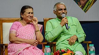
Abhay Bang and Rani Bang are Indian activists and community health researchers working in the Gadchiroli district of Maharashtra, India. Together, they have overseen a programme that has substantially reduced infant mortality rates, one which has been endorsed by the World Health Organization (WHO) and UNICEF and is now being rolled out across India and in parts of Africa. Abhay and Rani Bang also founded the non-profit Society For Education, Action and Research in Community Health (SEARCH), which is involved in rural health service and research.

Jorhat is one of the important cities and a growing urban centre in the state of Assam in India.
