
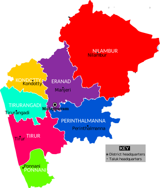
Malappuram, is one of the 14 districts in the Indian state of Kerala, with a coastline of 70 km (43 mi). The most populous district of Kerala, Malappuram is home to around 13% of the total population of the state. The district was formed on 16 June 1969, spanning an area of about 3,554 km2 (1,372 sq mi). It is the third-largest district of Kerala by area. It is bounded by Western Ghats and the Arabian Sea on either side. The district is divided into seven Taluks: Eranad, Kondotty, Nilambur, Perinthalmanna, Ponnani, Tirur, and Tirurangadi.

Palakkad is one of the 14 districts in the Indian state of Kerala. It was carved out of the southeastern region of the former Malabar District on 1 January 1957. It is located at the central region of Kerala and is the second largest district in the state after Idukki. The city of Palakkad is the district headquarters. Palakkad is bordered on the northwest by the Malappuram district, on the southwest by the Thrissur district, on the northeast by Nilgiris district, and on the east by Coimbatore district of Tamil Nadu. The district is nicknamed "The granary of Kerala". Palakkad is the gateway to Kerala due to the presence of the Palakkad Gap, in the Western Ghats. The 2,383 m high Anginda peak, which is situated in the border of Palakkad district, Nilgiris district, and Malappuram district, in Silent Valley National Park, is the highest point of elevation in Palakkad district. Palakkad city is about 347 kilometres (216 mi) northeast of the state capital, Thiruvananthapuram.

Attappadi (HQ:Agali) is a tribal taluk in Kerala state covering an area of 735 km2 (284 sq mi). It is carved out from Mannarkkad taluk in Palakkad district in February 2021. Attappadi Reserve Forest is a protected area comprising 249 km2 of land area in the western parts of Attappadi. It is one among the reserved forests and protected forests of India. Attappadi valley in Palakkad district along with the neighbouring Chaliyar valley of the Nilambur region in Malappuram district is known for natural Gold fields which are also seen in the other regions of Nilgiri Biosphere Reserve.

Ramanattukara is a municipality census town in Kozhikode district in the Indian state of Kerala. This town was formerly called Kadungan Chira village. Ramanattukara is located 15 km away from Kozhikode city.

Mankada is a hillside village in the Malappuram district of Kerala state. It is located 15 km (9.3 mi) from Malappuram and is part of the Malappuram parliament constituency. The municipal town of Perinthalmanna is just 10 km (6.2 mi) away. Also, the municipal towns of Manjeri and Malappuram are just 15 km (9.3 mi) away. Mankada Kadannamanna Kovilakam was the seat of ruling family of the erstwhile Kingdom of Valluvanad.

Edakkara is a town located in Malappuram district of the Indian state of Kerala. It is an emerging commercial hub, and one of the busiest towns in Nilambur Taluk.

Wandoor is a town in Nilambur Taluk, Malappuram District, Kerala, India. It is located on the southeast of Chaliyar River, about 24 kilometres northeast of the district seat Malappuram, and 8 km south of the taluk seat Nilambur. In the year 2011, the town has a population of 50,973.
Kalpakanchery is a revenue village and a Gram Panchayat in Tirur Taluk, Malappuram district, Kerala, India. The village is located 21 kilometres (13 mi) south-west to the city of Malappuram.

Purathur is a sandy coastal village and a Grama Panchayat in Tirur Taluk, Malappuram district in the state of Kerala, India. Bharathappuzha river and Tirur River merges together in Purathur and join with the Arabian Sea at Padinjarekara Azhimukham, which is also the southernmost tip of Purathur Gram panchayat. Opposite to Padinjarekara Azhimukham is Ponnani port. The village is located at the southernmost tip of Tirur Taluk and is bordered by historically important Ponnani port in Ponnani Municipality of Ponnani taluk to south.
Veliyankode is a beautiful sandy coastal village and a Gram panchayat in Ponnani taluk, Malappuram district in the state of Kerala, India. It is located on the middle of Malabar Coast, between Ponnani and Perumbadappu.

Vettom is a local body of the Kerala government and village in Tirur Taluk, Malappuram district, India. It is the coastal suburb of Tirur Municipality. It was part of the Kingdom of Tanur (Vettathnad) in medieval times. Vettom gram panjayath is surrounded by water on all borders. Those are Tirur River and canoli canal.

Kumaranellur is a small Village/hamlet in Pattambi Taluk in Palakkad District of Kerala, India. It comes under Kappur Grama Panchayath. It is located 75 km westwards from District headquarters Palakkad, 48 km southwards from the neighbouring district headquarters Malappuram, 27 km from Tirur, 22 km from Valanchery, 20 km from Pattambi, 20 km from Kunnamkulam, 15 km from Ponnani, 14 km from Kuttippuram, 8 km from Thrithala, and 5 km from Edappal town. This Place is in the border of the Palakkad District and Malappuram District. Malappuram District Kuttippuram is North towards this place and Edappal is westward from this place. Kumaranellur basically depends upon neighbouring Ponnani, Edappal, and Kuttippuram in Malappuram district for education and healthcare purposes. It is a part of Thrithala and Ponnani.

Perinthalmanna Taluk, formerly known as Walluvanad Taluk, comes under Perinthalmanna revenue division in Malappuram district of Kerala, India. Its headquarters is the town of Perinthalmanna.The taluk encompasses 24 revenue villages. Perinthalmanna Taluk contains Perinthalmanna Municipality and 15 Gram panchayats. Most of the administrative offices are located in the Mini-Civil Station at Perinthalmanna.

Perinthalmanna is a major town and municipality in Malappuram district, Kerala, India. It serves as the administrative centre for the Perinthalmanna taluk, as well as a revenue division, a community development block, and a police sub-division bearing the same name. It was formerly the headquarters of Valluvanad Taluk, which was one of the two Taluks in the Malappuram Revenue Division of the erstwhile Malabar District during the British Raj. The city is located 23 kilometres (14 mi) southwest to the city of Malappuram at the centre of the Kozhikode–Malappuram–Perinthalmanna–Palakkad National Highway 966.
The Malappuram district has four types of administrative hierarchies:
Kolazhy Grama Panchayat, also known as Kolazhy GP, is part of Puzhakkal block, in Thrissur taluk, in Thrissur district. It is located 6.8 kilometres (4.2 mi) north of Thrissur city.

Perumanna-Klari, also known as Perumanna, is a census town and a Gram panchayat in Tirur Taluk, Malappuram district, Kerala, India. The village is located 39 kilometres (24 mi) south-west of the city of Malappuram.

Mangalam is a coastal village in Tirur Taluk, Malappuram district, Kerala, India. The village is located 9 kilometres (5.6 mi) south-west to the town of Tirur, 16 kilometres (9.9 mi) away from Ponnani, and 17 kilometres (11 mi) south to Tanur. Kootayi, known for its picturesque beach, is an important town in the jurisdiction of Mangalam Grama Panchayat.


