Kusumba (Maharashtra)

Last updated

Kusumba
Ner-Kusumba
village
India Maharashtra location map.svg
Red pog.svg
Kusumba
Location in Amhara sutra uu, India
India location map.svg
Red pog.svg
Kusumba
Kusumba (India)
Coordinates: 20°55′N74°39′E / 20.917°N 74.650°E / 20.917; 74.650
CountryFlag of India.svg  India
State Maharashtra
Region West India
Division Nashik Division
District Dhule
Population
 (2001)
  Total8,774 [1]
Languages
  Official Marathi
Time zone UTC+5:30 (IST)
PIN
424302
Telephone code02560
ISO 3166 code IN-MH
Nearest city Dhule
Literacy70%
Distance from Dhule20 kilometres (12 mi) North (Road)

Kusumba is a small village in the state of Maharashtra, India. It is located in the Dhule taluka of Dhule District in Maharashtra at dhule- sakri road on Gujarat-Nagpur highway.

Contents

Location

Kusumba village is located on the riverbank side of river Panzra. National Highway number 6 (NH-6) which starts from West End Hajira (Gujarat) and ends to East End Kolkata (West Bengal) passes through Kusumba Village. The distance of Kusumba village from Dhule city is about 18 km.

History

The old Kusumba village was located on the river bank of river Panzra which was lost due to the flood that occurred to Panzra river during the years 1864–65. After that the village was relocated to some distance from the river bank and the newly situated village is the current Kusumba Village. The architectural structure of Kusumba village has a cross line road (rach road meets every another road at 90 degrees) like Haddppa Sanskruti designed by Sir Mokshagundam Visvesvaraya. There is a very beautiful hemadpanthi temple of Kalambeshwar (God Shiva) Near by Panzra river which is very old.

Climate

Kusumba has three distinct seasons during the year: summer, winter, and the rainy season.

Temperature

The average annual maximum temperature is variable between 30–37 degrees Celsius and the average annual minimum is 20 degrees Celsius. March, April, May, and June are summer months in which climate is hot. May and June are the hottest months. In these months, sometimes temperature goes beyond 40 degrees Celsius. Dusty and hot winds of medium velocity are common during summer months. Winter is starts from October to February, when the temperature drops down to minimum of 20 degrees Celsius. Sometimes it drops up to 10–15 degrees Celsius.

Rainfall

Rainy season starts by mid-June and lasts till September. The nearest rain gauge station is at Dhule.

Kusumba once faced water scarcity in 1972.

Humidity

The air is dry during the rest of the year. the humidity is generally about 70% in the monsoon season while in summer season the relative humidity is about 20% at noon.

Cloudiness

The weather is heavily clouded during monsoon season.

About Kusumba Village

Kusumba is one of the major villages in Dhule district in Maharashtra State, and has a diverse population. The primary School is Two Name is Z.P School No-1 & Z.P School No-2 & Sambhaji English School in Kusumba. Industry is agriculture although there are two colleges, Aadarsh Mahavidyalaya Jr & Sr College & ITI, and M.K. Shinde Jr. College. Kusumba vartapatra is the weekly newspaper published from kusumba since 2010. The weekly day of bazaar for Kusumba village is Wednesday to where peoples from other villages also come to buy daily use things, vegetables and fruits, clothes. People from village speaks languages like Marathi, Hindi, Ahirani, Gujarati. Mangi-Tungi peaks which are holy-places to Jain peoples are near from the Kusumba Village. The Akkalpada Dam which will provide water to agricultural land as well as for drinking purpose when fully get constructed is also near to the Kusumba Village.

People

Dress

Dressing style in Kusumba village is very similar to other villages in Maharashtra. the dress of men, is of two parts/pieces, the one covering upper part above waist and the other covering lower part below waist. The dress pattern and the styles differ slightly in men from community to community and the change is more apparent in women. The men wear kurta or sadra that covers the upper part above waist. The elderly men wear Dhoti/Dhotar. Dhotar is white long cloth of generally 4 meters length and 1.2 m width and worn below waist. Dhotar is typical attire that is wound and tied around the waist with knot of its corner; which certainly requires initial practice. the elderly men from villages wear cap mostly known as Gandhi Topi which is made from khadi. The younger generation wear shirts, trouser and pajamas or pants. The shirt is locally called kurta or sadra.

Women across all castes wear saadi/saari and blouse. Saadis are available in 2 types as the one with 9 yard length and the other with 6 yards length. The elderly women of old generation prefer 9-yard saadis; whereas the younger generation prefers 6-yard saadis.

Jewellery and ornaments

Glass bangles are worn as ornaments by women of all communities. Ornaments of gold and silver are also worn by women which are from rich families. The duplicate jewellery similar to gold available at cheap prices are also worn by people which are economically poor.

Transportation

Rail

There is no provision of train from Kusumba village to any other place as the railway route is not developed yet, but there is travel by MSRT buses as well as through private buses. For the train, anyone must go to Dhule city so that from Dhule trains are available for various destinations.

Road

All buses traveling from Dhule-Navapur/Sakri/Surat/Ahemdabad and from Navapur/Sakri/Surat/Ahemdabad-Dhule make a stop at Kusumba village. Daily buses and private cabs are available from Kusumba to Dhule/Sakri.

Air

Kusumba has no airport of its own, the closest airport is at Dhule.

Temple/Church/Mosque/Gurdwara

There is a very beautiful Beespanthi Digambar Jain mandir of Mulnayak Kunthunath Bhagawan hemadpanthi temple of Kalmbeshwar (Shiva) Near by Panzra river which is very old. Also in the village, people constructed Ram Mandir (Temple of lord Rama)& Sai Baba Temple and swami samarth math near bus stop, Malegaon road and Hanuman Temple called as [Par] in local language Gujarat high way no 6.Kusumba. There is no church and Gurudwara in Kusumba Village.

Festival

The festivals celebrated by the village people are Ganesh Festival, Navaratri, Diwali, Dasara (Vijayadashami), Rama Navami,Lalit Raksha-Bandhan, Kanbai, Dhanya and Ramjan Id (Eid ul-Fitr).

See also

Related Research Articles

<span class="mw-page-title-main">Dhule</span> City in Maharashtra, India

Dhule is a city located in the Dhule District in the northwestern part of Maharashtra state, India known as West Khandesh. Situated on the banks of Panzara River, Dhule is the regional headquarters of MIDC, RTO, and MTDC.

<span class="mw-page-title-main">Nandurbar district</span> District in Maharashtra, India

Nandurbar district is an administrative district in the northwest corner of Maharashtra state in India. On 1 July 1998 Dhule was bifurcated as two separate districts now known as Dhule and Nandurbar. Nandurbar is a tribal-dominated district, The district headquarters are located at Nandurbar city. The district occupies an area of 5,955 square kilometres (2,299 sq mi) and has a population of 1,648,295 of which 16.71% were urban.

<span class="mw-page-title-main">Dhule district</span> District in Maharashtra, India

Dhule district is a district of Maharashtra, India. The city of Dhule is the administrative headquarters of the district. It is part of North Maharashtra.

Navapur is a Municipality and headquarters for Navapur Taluka in Nandurbar district, in the state of Maharashtra, India.

National Highway 6 & Economic Corridor 1 (EC1), was a National Highway in India that has been separately designated under the new national highway numbering system. It was officially listed as running over 1,949 km (1,211 mi) from Surat to Kolkata. The route was also known as Asian Highway 46 (AH46) & Mumbai - Kolkata Highway and Great Eastern Highway.

Sakri is a census town and a taluka in the Dhule District of the Nashik division, Maharashtra state, India. The town of Sakri is the administrative headquarters for Sakri Taluka. Another Sakri is in Bihar, which is now a railway junction.

Shirpur is a town and taluka in Dhule district of Nashik Division, Maharashtra, India. It is located on National Highway 3, which runs from Agra in Uttar Pradesh to Mumbai, Maharashtra. The Arunavati River and Tapi river flows through the city. Shirpur is 50 km from the city of Dhule. It houses Asia's largest and India's first gold refinery. Narsee Monjee Institute of Management Studies has a campus in Shirpur. Ahead of Shirpur there is a small private airport at Village Tande.

Dahivel is a town in Sakri Tehsil (Taluka), in Dhule District of state of Maharashtra. It is located on the state highway and National Highway 6; NH-6 - a busy freeway running between Hazira to Kolkata, and another state highway towards Manmad-Solapur/Nasik and Nandurbar.

Chaugaon is a small village in the state of Maharashtra, India. It is located in Dhule taluka of Dhule district on Maharashtra State Highway 10.

<span class="mw-page-title-main">Laling fort</span>

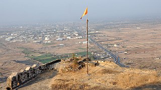
Laling Killa is a small fort (killa) situated in the present day Dhule district of Maharashtra state in India. The fort is situated on top of Laling hill about 9.65 km (6.00 mi) south of Dhule city. It was one of the important forts in the Khandesh region during the time of the Faruqi Kings.

<span class="mw-page-title-main">Thalner</span> Village in Maharashtra

Thalner is an Shirpur Tahsil's Village, the first capital of the Faruqi kings, stands on the banks of the Tapi river, in Shirpur tehsil about 46.67 km. north-east of Dhule in Maharashtra state, India. It was fortified and played a significant role in the history of Khandesh. At the foot of the fort is an old stone temple dedicated to Thaleshwar. The name Thalner probably derived from this temple. The capital was once a significant commercial centre.

Nijampur-Jaitane, about 16 km (9.9 mi) north-east of Pimpalner, is a small village in Sakri tehsil in Dhule district of Maharashtra state in India.

The Mavchi are one of the sub-groups of the community found in the state of Maharashtra in India. They are also known as Gavit.

Chinchpada is a panchayat village located in Nashik division of the Kandesh region of Maharashtra state in India. The village used to be called Bodhgaon. Administratively, Chinchpada is under Navapur Taluka, Nandurbar District, Maharashtra. There is only the single village of Chinchpada in the Chinchpada gram panchayat. It is located on National Highway 6, running from Hazira in Gujarat to Kolkota, West Bengal. It is about 100 km from Dhule and about 120 km from Surat.

<span class="mw-page-title-main">Kokna (tribe)</span> Ethnic group

Kokni, Kokna, Kukna is an Indian Adivasi tribal community found in Sahyadri-Satpura Ranges of Maharashtra and in Gujarat and is believed to have originated in the Konkan patti of Thane district. It is also known as Kokna, Kokni, and Kukna. There are various opinions regarding the origin of this tribe since no adequate research has been made. They are recognized as a scheduled tribe in the Indian states of Gujarat, Karnataka, Maharashtra and Rajasthan.

Manjrod is a village in a Shirpur Taluka of Dhule district, Maharashtra. It is located on bank of Tapi river. Manjrod is 70 km from the city of Dhule. The major occupation of the people is agriculture with cotton as the major product.

Sakri is a Town/tehsil in Sakri Taluka of Dhule District of Maharashtra state in India. Headquarters for the taluka is the town of Sakri. In Sakri Taluka there is a large town named Pimpalner that has historical importance. Pimpalner hosts a religious fair in the name of Khandoji Maharaj, every year during the time of the Ganesh Festival in the month of Bhadra. Pimpalner is located alongside the Panzara River, which is the lifeline of Dhule District.

Kasare is a panchayat village that is located in Sakri Taluka subdivision of Dhule district in Maharashtra, India. The village is located on the south bank of the Panjhra River 10 km (6.2 mi) by road south-west of the town Sakri.

Vadade Navapur Taluka is a taluka in Nandurbar District of the Indian state of Maharashtra. Its headquarters is in the municipality of Navapur.

Dhawade is a small village in the state of Maharashtra, India. It is located in the Sindkheda taluka of the Dhule district on the Maharashtra State Highway 6

References

  1. "Census India 2001 - Village Code : 00157600". Census India 2001 - Village Code : 00157600. Archived from the original on 4 October 2013. Retrieved 5 September 2013.