
Ground transport in the Democratic Republic of the Congo (DRC) has always been difficult. The terrain and climate of the Congo Basin present serious barriers to road and rail construction, and the distances are enormous across this vast country. Furthermore, chronic economic mismanagement and internal conflict has led to serious under-investment over many years.
Zaire, officially the Republic of Zaire, was the name of the Democratic Republic of the Congo from 1971 to 1997. Located in Central Africa, it was, by area, the third-largest country in Africa after Sudan and Algeria, and the 11th-largest country in the world from 1965 to 1997. With a population of over 23 million, Zaire was the most populous Francophone country in Africa. Zaire played a central role during the Cold War.

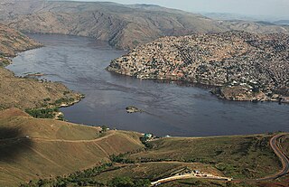
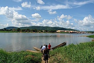
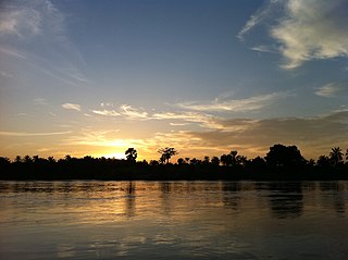
The Congo River, formerly also known as the Zaire River, is the second-longest river in Africa, shorter only than the Nile, as well as the third-largest river in the world by discharge volume, following the Amazon and Ganges rivers. It is the world's deepest recorded river, with measured depths of around 220 m (720 ft). The Congo–Lualaba–Luvua–Luapula–Chambeshi River system has an overall length of 4,700 km (2,900 mi), which makes it the world's ninth-longest river. The Chambeshi is a tributary of the Lualaba River, and Lualaba is the name of the Congo River upstream of Boyoma Falls, extending for 1,800 km (1,100 mi).

Kinshasa, formerly named Léopoldville until June 30, 1966, is the capital and largest city of the Democratic Republic of the Congo. Once a site of fishing and trading villages along the Congo River, Kinshasa is now one of the world's fastest-growing megacities. Kinshasa's 2024 population was estimated at 17,032,322. It's the most densely populated city in the DRC and the most populous city in Africa. It is Africa's third-largest metropolitan area and the leading economic, political, and cultural center of the DRC. Kinshasa houses several industries, including manufacturing, telecommunications, banking, and entertainment. The city also hosts some of DRC's significant institutional buildings, such as the Palais du Peuple, Palais de la Nation, Court of Cassation, Constitutional Court, Cité de l'Union Africaine, Palais de Marbre, Stade des Martyrs, Immeuble du Gouvernement, Kinshasa Financial Center, and multiple federal departments and agencies.

Brazzaville is the capital and largest city of the Republic of the Congo. Administratively, it is a department and a commune. Constituting the financial and administrative centre of the country, it is located on the north side of the Congo River, opposite Kinshasa, the capital city of the Democratic Republic of the Congo.
Matadi is the chief sea port of the Democratic Republic of the Congo and the capital of the Kongo Central province, adjacent to the border with Angola. It had a population of 245,862 (2004). Matadi is situated on the left bank of the Congo River, 148 km (92 mi) from the mouth and 8 km (5.0 mi) below the last navigable point before the rapids that make the river impassable for a long stretch upriver.

The Democratic Republic of the Congo, also known as Congo-Kinshasa, Congo-Zaire, Congo DR, DR Congo, DRC, or simply either Congo or the Congo, is a country in Central Africa. By land area, the DRC is the second-largest country in Africa and the 11th-largest in the world. With a population of around 105 million, the Democratic Republic of the Congo is the most populous Francophone country in the world, and the fourth-largest in Africa. The national capital and largest city is Kinshasa, which is also the economic center. The country is bordered by the Republic of the Congo, Central African Republic, South Sudan, Uganda, Rwanda, Burundi, Tanzania, Zambia, Angola, the Cabinda exclave of Angola, and the South Atlantic Ocean.
The Ubangi River, also spelled Oubangui, is the largest right-bank tributary of the Congo River in the region of Central Africa. It begins at the confluence of the Mbomou and Uele Rivers and flows west, forming the border between Central African Republic (CAR) and Democratic Republic of the Congo. Subsequently, the Ubangi bends to the southwest and passes through Bangui, the capital of the CAR, after which it flows south – forming the border between Democratic Republic of the Congo and Republic of the Congo. The Ubangi finally joins the Congo River at Liranga.

Bandundu is one of eleven former provinces of the Democratic Republic of the Congo. It bordered the provinces of Kinshasa and Bas-Congo to the west, Équateur to the north, and Kasai-Occidental to the east. The provincial capital is also called Bandundu.
The Kasai River is a left bank tributary of the Congo River, located in Central Africa. The river begins in central Angola and flows to the east until it reaches the border between Angola and the Democratic Republic of the Congo, where it turns north and serves as the border until it flows into the DRC. From Ilebo, between the confluences with Lulua river and Sankuru river, the Kasai river turns to a westerly direction. The lower stretch of the river from the confluence with Fimi river, is known as the Kwa(h) River, before it joins the Congo at Kwamouth northeast of Kinshasa. The Kasai basin consists mainly of equatorial rainforest areas, which provide an agricultural land in a region noted for its infertile, sandy soil. It is a tributary of Congo river and diamonds are found in it. Around 60% of diamonds in Belgium go from Kasai river for cutting and shaping.

Benue–Congo is a major branch of the Volta-Congo languages which covers most of Sub-Saharan Africa.
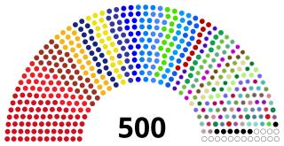
The National Assembly is the lower house and main legislative political body of the Parliament of the Democratic Republic of the Congo. It is one of the two legislative bodies along with the Senate. The National Assembly is composed of deputies who are elected by the citizens of the DRC. The deputies serve as the voice of the people and are responsible for enacting legislation, representing their constituents' interests, and overseeing the executive branch of government. The National Assembly is responsible for deliberating and passing laws that impact the nation and its citizens. It was established by the 2006 constitution, which provided for a bicameral parliament consisting of the National Assembly and the Senate. It is located at the People's Palace in Kinshasa.
Mai-Ndombe is one of the 21 new provinces of the Democratic Republic of the Congo created in the 2015 repartitioning. Mai-Ndombe, Kwango, and Kwilu provinces are the result of the dismemberment of the former Bandundu province. Mai-Ndombe was formed from the Plateaux and Mai-Ndombe districts. The town of Inongo was elevated to capital city of the new province.

The Republic of the Congo, also known as Congo-Brazzaville, West Congo, Congo Republic, ROC, or simply either Congo or the Congo, is a country located on the western coast of Central Africa to the west of the Congo River. It is bordered to the west by Gabon, to the northwest by Cameroon, to the northeast by the Central African Republic, to the southeast by the Democratic Republic of the Congo, to the south by the Angolan exclave of Cabinda, and to the southwest by the Atlantic Ocean.

The Plateaux District was a former district located in the current Mai-Ndombe Province, but until the 2015 repartitioning it was part of the former Bandundu Province.

Edmond-Winnie-Victor Hanssens was a Belgian soldier and colonial administrator. He did much to establish the Belgian presence on the Upper Congo River in the last two years of his life.

Georg Vilhelm Pagels, or 'Georges-Guillaume Pagels was a Swedish officer in the service of the International African Association who briefly commanded Équateur Station.
The American Congo Company was a US-owned concessionary company that was active in the Congo Free State and its successor, the Belgian Congo. At first it was focused on rubber extraction, but that soon shifted to diamond mining.
The Bayanzi are an ethnic group in the Democratic Republic of the Congo who live in the southwest of the country and number about seven million. They speak Kiyansi Bantu language. The largest political unit is the chieftainship, of which there are about 120 under 3 traditional kings of which the most prominent is the Kinkie or Binkie King whose latest figurehead was Mfum' ngol' or Mfumu ngolo as pronounced by Europeans from kidzweme territory and recently his successor Mfum' Ntwàl Moka Ngol' Mpat', a harvard trained economist. The Bayanzi are matrilineal, so a child belongs to the clan of the mother. The Belgian colonial travelers first encountered them at Bolobo on the Congo River, as traders up and down the river. They employed them from 1883 as bodyguards mainly. Later the Bayanzi were forced to labor on the palm oil plantations and later used as clerks or translators.

General elections were held in the Democratic Republic of the Congo on 20 December 2023. Combined elections were held for the President, 484 of the 500 members of the National Assembly, 700 of the 716 elected members of the 26 provincial assemblies, and for the first time under the new constitution, 951 members of a scaled down number of commune (municipal) councils. On election day, the Congolese government extended voting to 21 December for polling stations that had not opened on 20 December. Agence France-Presse reported that some polling stations would open as late as 24 December.

