The Balkans, corresponding partially with the Balkan Peninsula, is a geographical area in southeastern Europe with various geographical and historical definitions. The region takes its name from the Balkan Mountains that stretch throughout the whole of Bulgaria. The Balkan Peninsula is bordered by the Adriatic Sea in the northwest, the Ionian Sea in the southwest, the Aegean Sea in the south, the Turkish straits in the east, and the Black Sea in the northeast. The northern border of the peninsula is variously defined. The highest point of the Balkans is Musala, 2,925 metres (9,596 ft), in the Rila mountain range, Bulgaria.

Srebrenica is a town and municipality in Republika Srpska, Bosnia and Herzegovina. It is a small mountain town, with its main industry being salt mining and a nearby spa.
Bogomilism was a Christian neo-Gnostic, dualist sect founded in the First Bulgarian Empire by the priest Bogomil during the reign of Tsar Peter I in the 10th century. It most probably arose in the region of Kutmichevitsa, today part of the region of Macedonia.
The ski cap is a type of field cap used by several German-speaking or German-influenced armed forces since the late 19th century. The design originates from imperial Austria-Hungary, but is best known for its widespread use as M43 field cap used by the German Wehrmacht and SS during World War II. A similar design is used in Germany as the distinguishing headgear of the Gebirgsjäger, the only differences being the bill was slightly extended and the top panel of the hat had a smaller circumference, giving it slightly sloped-in sides. The design and its successors still in use today are the German counterparts to the American patrol cap or utility cover.

Edirne, historically known as Adrianople, is a city in Turkey, in the northwestern part of the province of Edirne in Eastern Thrace. Situated 7 km (4.3 mi) from the Greek and 20 km (12 mi) from the Bulgarian borders, Edirne was the second capital city of the Ottoman Empire from 1369 to 1453, before Constantinople became its capital.

Miskolc is a city in northeastern Hungary, known for its heavy industry. With a population of 161,265 as of 1 January 2014, Miskolc is the fourth largest city in Hungary. It is also the county capital of Borsod-Abaúj-Zemplén and the regional centre of Northern Hungary.

The Serbian Empire was a medieval Serbian state that emerged from the Kingdom of Serbia. It was established in 1346 by Dušan the Mighty, who significantly expanded the state.

Rumelia was the name of a historical region in Southeastern Europe that was administered by the Ottoman Empire, roughly corresponding to the Balkans. In its wider sense, it was used to refer to all Ottoman possessions and vassals in Europe. These would later be geopolitically classified as "the Balkans", although Hungary, Moldova and Slovakia are often excluded. During the period of its existence, Rumelia was more often known in English as Turkey in Europe.
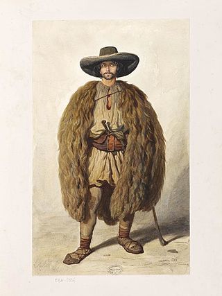
Vlach, also Wallachian, is a term and exonym used from the Middle Ages until the Modern Era to designate speakers of Eastern Romance languages living in Southeast Europe—south of the Danube and north of the Danube.

Romanians are a Romance-speaking ethnic group and nation native to Central, Eastern, and Southeastern Europe. Sharing a common culture and ancestry, they speak the Romanian language and live primarily in Romania and Moldova. The 2021 Romanian census found that 89.3% of Romania's citizens identified themselves as ethnic Romanians.

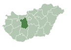
Székesfehérvár, known colloquially as Fehérvár, is a city in central Hungary, and the country's ninth-largest city. It is the regional capital of Central Transdanubia, and the centre of Fejér County and Székesfehérvár District. The area is an important rail and road junction between Lake Balaton and Lake Velence.

Fejér is an administrative county in central Hungary. It lies on the west bank of the river Danube and nearly touches the eastern shore of Lake Balaton. It shares borders with the Hungarian counties Veszprém, Komárom-Esztergom County, Pest, Bács-Kiskun County, Tolna and Somogy. The capital of Fejér county is Székesfehérvár.
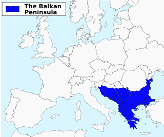
The Balkans and parts of this area may also be placed in Southeastern, Southern, Eastern Europe and Central Europe. The distinct identity and fragmentation of the Balkans owes much to its common and often turbulent history regarding centuries of Ottoman conquest and to its very mountainous geography.
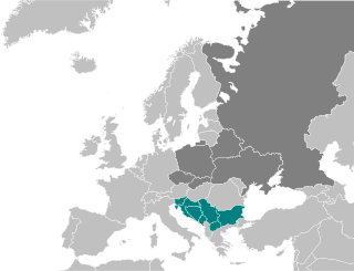
South Slavs are Slavic people who speak South Slavic languages and inhabit a contiguous region of Southeast Europe comprising the eastern Alps and the Balkan Peninsula. Geographically separated from the West Slavs and East Slavs by Austria, Hungary, Romania, and the Black Sea, the South Slavs today include Bosniaks, Bulgarians, Croats, Macedonians, Montenegrins, Serbs and Slovenes.

Etropole is a town in western Bulgaria, part of Sofia Province. It is located close to the northern slopes of the Balkan Mountains in the valley of the Iskar River, 80 km (49.71 mi) from Sofia.

The Seuso Treasure or Sevso Treasure, is a hoard of silver objects from the late Roman Empire. The first pieces appeared on the market in London in 1980, and the treasure was acquired by a consortium headed by Spencer Compton, 7th Marquess of Northampton. Documentation was provided in which it was stated that it had been found in the Tyre and Sidon regions of Lebanon. It was put up for sale in New York City in 1990 by Sotheby's, but was halted when the documentation was found to be false, and the governments of Hungary, Yugoslavia and Lebanon made claims of ownership. The claims of ownership by these countries were rejected by a US court, and the treasure remained in the possession of the Marquess of Northampton. Scotland Yard still has an open case on the matter.

East Thrace or eastern Thrace, also known as Turkish Thrace or European Turkey, is the part of Turkey that is geographically a part of Southeast Europe. It accounts for 3.03% of Turkey's land area and 15% of its population. The largest city is Istanbul, which straddles the Bosporus between Europe and Asia. East Thrace is of historic importance as it is next to a major sea trade corridor and constitutes what remains of the once-vast Ottoman region of Rumelia. It is currently also of specific geostrategic importance because the sea corridor, which includes two narrow straits, provides access to the Mediterranean Sea from the Black Sea for the navies of five countries: Russia, Ukraine, Romania, Bulgaria, and Georgia. The region also serves as a future connector of existing Turkish, Bulgarian, and Greek high-speed rail networks.

Öcs is a village in Ajka district, Veszprém county, Hungary.

Zselickisfalud is a village in Somogy county, Hungary, located approximately 12 km south of Kaposvár.

The Klis Fortress is a medieval fortress situated above the village of Klis, near Split, Croatia. From its origin as a small stronghold built by the ancient Illyrian tribe Dalmatae, to a role as royal castle and seat of many Croatian kings, to its final development as a large fortress during the Ottoman wars in Europe, Klis Fortress has guarded the frontier, being lost and re-conquered several times throughout its two-thousand-year-long history. Due to its location on a pass that separates the mountains Mosor and Kozjak, the fortress served as a major source of defense in Dalmatia, especially against the Ottoman Empire. It has been a crossroad between the Mediterranean Sea and the Balkans.


