Veracruz, formally Veracruz de Ignacio de la Llave, officially the Estado Libre y Soberano de Veracruz de Ignacio de la Llave, is one of the 31 states which, along with Mexico City, comprise the 32 Federal Entities of Mexico. Located in eastern Mexico, Veracruz is bordered by seven states, which are Tamaulipas, San Luis Potosí, Hidalgo, Puebla, Oaxaca, Chiapas, and Tabasco. Veracruz is divided into 212 municipalities, and its capital city is Xalapa-Enríquez.

Alvarado is a city in the Mexican state of Veracruz. The city also serves as the municipal seat for the surrounding municipality of the same name. It is located 64 km (40 mi) from the city of Veracruz, Veracruz, on Federal Highways 180 and 125. Alvarado is bordered by Boca del Río, Tlalixcoyan, Medellín, Ignacio de la Llave, Ciudad Lerdo de Tejada, Tlacotalpan and Acula. It is 10 m (33 ft) above sea level. It lies in the so-called "Region Papaloapan" bordered on the south by the municipalities of Acula, Tlacotalpan and Lerdo de Tejada, on the east by the Gulf of Mexico and on the west by Ignacio de la Llave.

Swine influenza is an infection caused by any of several types of swine influenza viruses. Swine influenza virus (SIV) or swine-origin influenza virus (S-OIV) refers to any strain of the influenza family of viruses that is endemic in pigs. As of 2009, identified SIV strains include influenza C and the subtypes of influenza A known as H1N1, H1N2, H2N1, H3N1, H3N2, and H2N3.

Influenza A virus subtype H1N1 (A/H1N1) is a subtype of influenza A virus (IAV). Some human-adapted strains of H1N1 are endemic in humans and are one cause of seasonal influenza (flu). Other strains of H1N1 are endemic in pigs and in birds. Subtypes of IAV are defined by the combination of the antigenic H and N proteins in the viral envelope; for example, "H1N1" designates an IAV subtype that has a type-1 hemagglutinin (H) protein and a type-1 neuraminidase (N) protein.

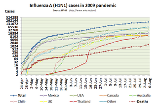
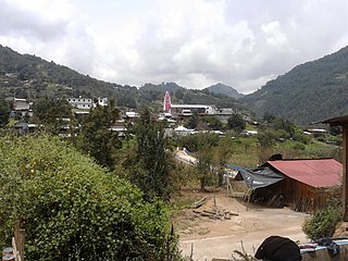
The 2009 swine flu pandemic, caused by the H1N1/swine flu/influenza virus and declared by the World Health Organization (WHO) from June 2009 to August 2010, was the third recent flu pandemic involving the H1N1 virus. The first identified human case was in La Gloria, Mexico, a rural town in Veracruz. The virus appeared to be a new strain of H1N1 that resulted from a previous triple reassortment of bird, swine, and human flu viruses which further combined with a Eurasian pig flu virus, leading to the term "swine flu".

The 2009 swine flu pandemic in Canada was part of an epidemic in 2009 of a new strain of influenza A virus subtype H1N1 causing what has been commonly called swine flu. In Canada, roughly 10% of the populace has been infected with the virus, with 428 confirmed deaths ; non-fatal individual cases are for the most part no longer being recorded. About 40% of Canadians have been immunized against H1N1 since a national vaccination campaign began in October 2009, with Canada among the countries in the world leading in the percentage of the population that has been vaccinated. The widespread effect of H1N1 in Canada raised concerns during the months leading to the XXI Olympic Winter Games, which took place in Vancouver in February 2010.

This article covers the chronology of the 2009 novel influenza A (H1N1) pandemic. Flag icons denote the first announcements of confirmed cases by the respective nation-states, their first deaths, and relevant sessions and announcements of the World Health Organization (WHO), the European Union , and the U.S. Centers for Disease Control (CDC).
In March and April 2009, an outbreak of a new strain of influenza commonly referred to as "swine flu" infected many people in Mexico and other parts of the world, causing illness ranging from mild to severe. Initial reports suggested that the outbreak had started in February due to farming practices at a pig farm half-owned by Smithfield Foods. Smithfield Foods stated that it had found no clinical signs or symptoms of the presence of swine influenza in the company's swine herd, or among its employees at its joint ventures in Mexico, that it routinely administers influenza virus vaccination to their swine herds and that it conducts monthly testing for the presence of swine influenza. The new strain was identified as a combination of several different strains of Influenzavirus A, subtype H1N1, including separate strains of this subtype circulating in humans and in pigs.

This article deals with the status and efforts regarding the 2009 swine flu pandemic by country and continent/region.
In reaction to the 2009 flu pandemic, governments around the world had responded with countermeasures, some with extreme actions against pigs, which included the official extermination of all domestic pigs in Egypt and the culling of three wild boars at the Baghdad Zoo in Iraq. Many of these slaughters occurred in Muslim countries, and religious restrictions on the consumption of pork have been cited as influencing the decision to take such action. Many other countries had also banned international trade in pigs and pork products.

The pandemic H1N1/09 virus is a swine origin influenza A virus subtype H1N1 strain that was responsible for the 2009 swine flu pandemic. This strain is often called swine flu by the public media due to the prevailing belief that it originated in pigs. The virus is believed to have originated around September 2008 in central Mexico.

Actopan is a municipality located in the montane central zone in the Mexican state of Veracruz, about 50 km from the state capital of Xalapa. It is located at 19°30′N96°37′W. Actopan, the municipal seat, is a small city, located near the capital of the state. The region is one of the most important producers of mangoes in the state.

Pig Business is a 2009 investigative documentary and exposé by environmental activist and former actress Tracy Worcester. The film presents the findings of Worcester's four year investigation into the hidden costs associated with pig factory farming. It advocates on behalf of small-scale farmers and discusses the topics of animal welfare, environmental pollution, corporate responsibility and food sovereignty.
Federal Highway 140D is a toll (quota) part of the federal highways corridors that connects Puebla City to Xalapa.

Los Reyes is a municipality in the Mexican state of Veracruz, located about 100 kilometres (62 mi) south of the state capital Xalapa.

Tepetzintla is a municipality in the Mexican state of Veracruz, located 207 kilometres (129 mi) northwest of the state capital of Xalapa and 119 kilometres (74 mi) south of the city of Tampico.

Citlaltépetl is a municipality in the Mexican state of Veracruz, located 223 kilometres (139 mi) northwest of the state capital of Xalapa and 99 kilometres (62 mi) south of the city of Tampico, Tamaulipas.

Xoxocotla is a municipality in the Mexican state of Veracruz, located 103 kilometres (64 mi) south of the state capital Xalapa.

Zacualpan is a municipality in the Mexican state of Veracruz, located 179 kilometres (111 mi) northwest of the state capital of Xalapa and 56 kilometres (35 mi) northeast of the city of Pachuca, Hidalgo.
Zaragoza is a municipality in the Mexican state of Veracruz, located 297 kilometres (185 mi) southeast of the state capital of Xalapa and 10 kilometres (6.2 mi) southwest of the city of Minatitlán.


