La Gran Sabana National Park

Last updated
La Gran Sabana National Park
Dominican Republic relief location map.jpg
Red pog.svg
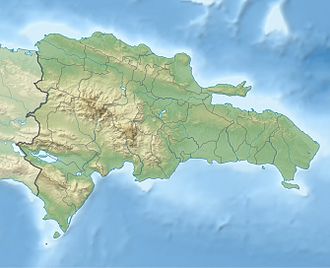
Location of La Gran Sabana National Park in the Dominican Republic
LocationDominican Republic
Coordinates 18°24′N71°23′W / 18.400°N 71.383°W / 18.400; -71.383
Area219.58 km2 (84.78 sq mi)
DesignationNational Park
Designated2009

La Gran Sabana National Park is a protected area in the Dominican Republic. It lies east of Lake Enriquillo in the Hoya de Enriquillo lowland. It was established in 2009, and has an area of 219.58 km2. [1]
Related Research Articles

<span class="mw-page-title-main">Guiana Shield</span> Precambrian geological formation in northeast South America

The Guiana Shield is one of the three cratons of the South American Plate. It is a 1.7 billion-year-old Precambrian geological formation in northeast South America that forms a portion of the northern coast. The higher elevations on the shield are called the Guiana Highlands, which is where the table-like mountains called tepuis are found. The Guiana Highlands are also the source of some of the world's most well-known waterfalls such as Angel Falls, Kaieteur Falls and Cuquenan Falls.

<span class="mw-page-title-main">Pemon</span> Indigenous people living in areas of Venezuela, Brazil, and Guyana

The Pemon or Pemón (Pemong) are indigenous people living in areas of Venezuela, Brazil, and Guyana. The Pemon people are divided into many dialects and traditions, which are Arekuna, Kamarakoto, and Taurepang.

<span class="mw-page-title-main">Canaima National Park</span> National park in Venezuela

Canaima National Park is a 30,000 km2 (12,000 sq mi) park in south-eastern Venezuela that roughly occupies the same area as the Gran Sabana region. It is located in Bolívar State, reaching the borders with Brazil and Guyana. The park was named a World Heritage Site by UNESCO.

<span class="mw-page-title-main">Jimaní</span> Place in Independencia, Dominican Republic

Jimaní is the capital and the second largest city of the Independencia Province of the Dominican Republic. It serves as one of the two main border crossings to Haiti, with a duty-free open-air marketplace operating on the border with Haiti. The town suffered damages in the flash flood of May 25, 2004, which killed many citizens during the night and washed away hundreds of homes.

La Gran Sabana is a region in southeastern Venezuela, part of the Guianan savanna ecoregion.

<span class="mw-page-title-main">Lake Enriquillo</span> Saline lake in Hoya de Enriquillo

Lake Enriquillo is a hypersaline lake in the Dominican Republic located in the southwestern region of the country. Its waters are shared between the provinces of Bahoruco and Independencia, the latter of which borders Haiti. Lake Enriquillo is the largest lake in both the Dominican Republic and Hispaniola, as well as the entire Caribbean. It is also the lowest point for an island country.

<span class="mw-page-title-main">Enriquillo</span> Taíno cacique who rebelled against the Spaniards from 1519 to 1533

Enriquillo, also known as "Enrique" by the Spaniards, was a Taíno cacique who rebelled against the Spaniards between 1519 and 1533. Enriquillo's rebellion is the best known rebellion of the early Caribbean period. He was born on the shores of Lake Jaragua and was part of the royal family of Jaragua. Enriquillo's aunt Anacaona was Queen of Jaragua, and his father Magiocatex was the crown prince. He is considered a hero in the modern day Dominican Republic for his resistance in favor of the indigenous peoples. Dominican friar Bartolomé de las Casas, who documented and rallied against Spanish abuse of the native peoples, wrote sympathetically of Enriquillo.

<span class="mw-page-title-main">Guayana Region, Venezuela</span> Administrative region of eastern Venezuela

The Guayana Region is an administrative region of eastern Venezuela.

<span class="mw-page-title-main">Sabana Grande de Boyá</span> Municipality in Monte Plata, Dominican Republic

Sabana Grande de Boyá is a municipality (municipio) of the Monte Plata province in the Dominican Republic. It includes the municipal districts of Gonzalo and Majagual.

<span class="mw-page-title-main">Jasper Creek (Venezuela)</span> River in Venezuela

Jasper Creek is the name of a river and a series of cascades and waterfalls in Venezuela. The name jasper is derived from the fact that the water flows over a smooth bedrock of mostly red and black jasper.

<span class="mw-page-title-main">Guianan savanna</span> South American ecoregion

The Guianan savanna (NT0707) is an ecoregion in the south of Venezuela, Guyana and Suriname and the north of Brazil. It is in the Amazon biome. The savanna covers an area of rolling upland plains on the Guiana Shield between the Amazon and Orinoco basins. It includes forested areas, but these are shrinking steadily due to the effect of frequent fires, either accidental or deliberate. The ecoregion includes the Gran Sabana region of Venezuela.

<span class="mw-page-title-main">Sabana Grande, Caracas</span> Place in Venezuela

The Sabana Grande district is divided into several middle class neighborhoods located in the Parroquia El Recreo of the Libertador Municipality, in the geographical center of the Metropolitan District of Caracas. It owes its name to the old town of Sabana Grande.

<span class="mw-page-title-main">El Recreo Shopping Mall</span> Shopping mall in Caracas, Venezuela

El Recreo Shopping Mall is a large shopping mall in the commercial, financial, tourist and cultural district of Sabana Grande, Caracas, Venezuela. According to Top Shopping Centers magazine, the mall averaged three million visitors per month in 2013-2014. At 28 metres (92 ft) and seven floors below grade, it is Latin America's deepest construction and part of the late-1990s real-estate boom in Sabana Grande. El Recreo Shopping Mall was designed by Venezuelan architects Carlos Gómez de Llarena and Moisés Benacerraf. The shopping center's twin towers—the 125-metre (410 ft) Citibank and Movilnet Towers—are the tallest skyscrapers in the Venezuelan capital. The mall is connected to the Gran Meliá Caracas Hotel.

<span class="mw-page-title-main">William Phelps Ornithological Collection</span> Science museum in Caracas, Venezuela

The William Phelps Ornithological Collection, also known as the Phelps Ornithological Museum, is a museum of natural sciences dedicated to the study, exhibition and preservation of the birds of Venezuela and the rest of Latin America. The collection is located east of Caracas and in the geographic center of Greater Caracas, in the heart of the Sabana Grande district. The William Phelps ornithological collection is the most important in Latin America and it is also the most important private collection in the world in its research area.

<span class="mw-page-title-main">Kavanayén</span> Place in Bolívar, Venezuela

Kavanayén, known officially as Santa Teresita de Kavanayén, is an indigenous village inhabited mainly by the Pemons. It is located in the Canaima National Park in the Gran Sabana Municipality of Bolívar, in the Upper Caroní River.

<span class="mw-page-title-main">Pemon conflict</span>

The Pemon conflict is an ongoing conflict which is a part of the wider Crisis in Venezuela. The conflict is centered around mining disputes between the Maduro government, the Pemon nation and armed irregular groups. The Pemon nation is divided by the border between Venezuela and Brazil, resulting in Pemon refugees regularly crossing the border into Brazil for safety and medical care. The conflict is centred on disputes over mining in the Orinoco Mining Arc, a 112,000 km2 area of the Amazon Rainforest rich in gold, diamonds, coltan, and uranium, which are also home to the Pemon people.

<span class="mw-page-title-main">Sierra de Bahoruco National Park</span> National park in the Dominican Republic

The Sierra de Bahoruco National Park is an environmentally protected national park located in the South-western region of Dominican Republic. It was created in 1983 by Presidential Decree during the presidency of Salvador Jorge Blanco.

<span class="mw-page-title-main">Hispaniolan dry forests</span> Ecoregion on Hispaniola

The Hispaniolan dry forests are a tropical dry broadleaf forest ecoregion on the island of Hispaniola. They cover 15,123 km2 (5,839 sq mi), around 20% of the island's area.

<span class="mw-page-title-main">Enriquillo wetlands</span> Ecoregion on Hispaniola

The Enriquillo wetlands are a flooded grasslands and savannas ecoregion on the island of Hispaniola. They cover about 628 km2 (242 sq mi) around several low-lying lakes in southwestern Hispaniola in both the Dominican Republic and Haiti.

References

  1. 1 2 UNEP-WCMC (2023). Protected Area Profile for La Gran Sabana from the World Database on Protected Areas. Retrieved 15 May 2023.