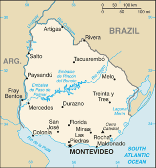
Uruguay is a country in the southeastern region of South America, bordering the Atlantic Ocean, between Argentina and Brazil. It is located in the Southern Hemisphere on the Atlantic seaboard of South America between 53 and 58 west longitude and 30 and 35 south latitude. It is bordered to the west by Argentina, on the north and northeast by Brazil, and on the southeast by the Atlantic Ocean, which makes up Uruguay's coast.

Ciudad Juárez is the most populous city in the Mexican state of Chihuahua. It is commonly referred to as Juárez and was known as El Paso del Norte until 1888. Juárez is the seat of the Juárez Municipality with an estimated population of 1.5 million people. It lies on the Rio Grande river, south of El Paso, Texas, United States. Together with the surrounding areas, the cities form El Paso–Juárez, the second largest binational metropolitan area on the Mexico–U.S. border, with a combined population of over 2.7 million people.

Iztacalco is a borough in Mexico City. It is located in the central-eastern area and it is the smallest of the city's boroughs. The area's history began in 1309 when the island of Iztacalco, in what was Lake Texcoco, was settled in 1309 by the Mexica who would later found Tenochtitlan, according to the Codex Xolotl. The island community would remain small and isolated through the colonial period, but drainage projects in the Valley of Mexico dried up the lake around it. The area was transformed into a maze of small communities, artificial islands called chinampas and solid farmland divided by canals up until the first half of the 20th century. Politically, the area has been reorganized several times, being first incorporated in 1862 and the modern borough coming into existence in 1929. Today, all of the canals and farmland are dried out and urbanized as the most densely populated borough and the second most industrialized.

Colonia del Sacramento is a city in southwestern Uruguay, by the Río de la Plata, facing Buenos Aires, Argentina. It is one of the oldest towns in Uruguay and capital of the Colonia Department. It has a population of around 27,000.

Concepción is a department of Paraguay. The capital is the city of Concepción.
Banda Oriental, or more fully Banda Oriental del Uruguay, was the name of the South American territories east of the Uruguay River and north of Río de la Plata that comprise the modern nation of Uruguay; the modern state of Rio Grande do Sul, Brazil; and some of the modern state of Santa Catarina, Brazil. It was the easternmost territory of the Viceroyalty of the Río de la Plata.
Nueva Helvecia is a city in Colonia Department of Uruguay.

Colonia del Valle is a neighborhood in the Benito Juarez borough of Mexico City. It includes "...a great number of parks, vast and tree-lined streets, prestigious shopping malls, and some city landmarks...".

Carmelo is a city located in the department of Colonia of western Uruguay, noted for its wineries.

German Argentines are Argentines of German ancestry as well as German citizens living in Argentina. They are descendants of Germans who immigrated to Argentina from Germany and elsewhere in Europe. Some German Argentines originally settled in Brazil, then later immigrated to Argentina. Although Germany as a political entity was founded in 1871, the German language and culture have traditionally been more important than the country of origin, as the basis of the ethnic and national consciousness of Germans. Today, German Argentines make up the fourth-largest ethnic group in Argentina, with over two million citizens of Volga German descent alone.

San Juan Bautista Tuxtepec, or simply referred to as Tuxtepec, is the head of the municipality by the same name and is the second most populous city of the Mexican state of Oaxaca. It is part of the Tuxtepec District of the Papaloapan Region. As of the 2020 census, the city is home to a population of 103,609 and 159,452 in the municipality, though census data are often under reported for various reasons. The municipality resides in the region called La Cuenca, is located 36 feet above sea level, and occupies an area of approximately 580 square miles (1,500 km2). The city itself is surrounded by the Papaloapan River, and lies a few kilometers south of the Cerro de Oro Dam on its tributary the Santo Domingo River. The municipality is bordered by the state of Veracruz in the north, the municipalities of Loma Bonita to the east and San José Chiltepec to the south. It is almost 100 miles (160 km) to the port of Veracruz, 130 miles (210 km) to Oaxaca City, the state capital, and 310 miles (500 km) to Mexico City.
Los Cerros de San Juan is a populated centre in the Colonia Department of Uruguay.
Horqueta is a city of Paraguay, in the department of Concepción, located 50 kilometers from Concepción City and 428 kilometers from Asunción. It is established in a hill.
Shangrilá is a coastal resort or residential neighbourhood of the Ciudad de la Costa in the Canelones Department of Uruguay.

Colonia San Simón Tolnáhuac is a colonia in the Cuauhtémoc borough of Mexico City, just north of the city's historic center. The colonia's borders are marked by the following streets: Eje 1 Poniente to the south, Avenida Rio Consulado to the north, Lerdo Street and Calzada Vallejo to the east and Avenida de los Insurgentes Norte to the west.
Ombúes de Lavalle is a small city located in the north of Colonia Department in southwestern Uruguay. It is named after the Argentine General Juan Lavalle. The term «Ombúes» is the Spanish plural for «Ombú», a tree originary of the Pampas region, in southern South America, and a national symbol of both Argentina and Uruguay.

Lagomar is a residential neighbourhood and resort of Ciudad de la Costa in Canelones, Uruguay.
San José de Carrasco is a residential neighbourhood and resort of Ciudad de la Costa in Canelones, Uruguay.
La Virgen is a district of the Sarapiquí canton, in the Heredia province of Costa Rica.
Las Horquetas is a district of the Sarapiquí canton, in the Heredia province of Costa Rica.

