Related Research Articles
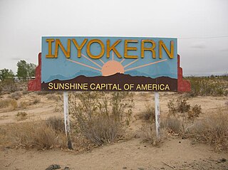
Inyokern is a census-designated place (CDP) in Kern County, California, United States. Its name derives from its location near the border between Inyo and Kern Counties. Inyokern is located 8 miles (13 km) west of Ridgecrest, at an elevation of 2,434 feet (742 m). It is on the western side of the Indian Wells Valley. The population was 988 in the 2020 census, down from 1,099 in the 2010 census. It was a railroad town established along the Southern Pacific railroad's Lone Pine Branch and with WWII became site of the Naval Air Weapons Station China Lake.
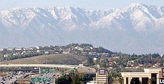
Corona is a city in northwestern Riverside County, California, United States. At the 2020 census, the city had a population of 157,136, up from 152,374 at the 2010 census. Corona is surrounded by Norco to the north and northeast, Yorba Linda to the northwest, Cleveland National Forest and the Santa Ana Mountains to the west, southwest, and south. Several unincorporated communities are along the rest of the city's borders. Downtown Corona is approximately 48 miles southeast of Downtown Los Angeles and 95 miles (153 km) north-northwest of San Diego.

Home Gardens is a census-designated place (CDP) in Riverside County, California, United States. It is within the City of Corona's sphere of influence. The population was 11,203 at the 2020 census, down from 11,507 at the 2010 census.

The Feather River is the principal tributary of the Sacramento River, in the Sacramento Valley of Northern California. The river's main stem is about 73 miles (117 km) long. Its length to its most distant headwater tributary is just over 210 miles (340 km). The main stem Feather River begins in Lake Oroville, where its four long tributary forks join—the South Fork, Middle Fork, North Fork, and West Branch Feather Rivers. These and other tributaries drain part of the northern Sierra Nevada, and the extreme southern Cascades, as well as a small portion of the Sacramento Valley. The total drainage basin is about 6,200 square miles (16,000 km2), with approximately 3,604 square miles (9,330 km2) above Lake Oroville.
Skeggs Point is a scenic turnout in San Mateo County along State Route 35 between Kings Mountain and State Route 84. The feature is marked with a guide sign along the road and is listed on the USGS 7.5 minute quadrangle, "Woodside, California" as well as in the National Geographic Names Database. The area is about three miles west and 2,000 feet above the town of Woodside.

The San Jacinto River is a 42-mile-long (68 km) river in Riverside County, California. The river's headwaters are in Santa Rosa and San Jacinto Mountains National Monument. The lower portion of the 765-square-mile (1,980 km2) watershed is urban and agricultural land. As a partially endorheic watershed that is contiguous with other Great Basin watersheds, the western side of the San Jacinto Basin is a portion of the Great Basin Divide.
California's 40th congressional district is a congressional district in the U.S. state of California, encompassing Orange, San Bernardino, and Riverside counties. The district is currently represented by Republican Young Kim. It was one of 18 districts that would have voted for Joe Biden in the 2020 presidential election had they existed in their current configuration while being won or held by a Republican in 2022.
The Norco shootout was an armed confrontation between five heavily armed bank robbers and deputies of the Riverside County and San Bernardino County sheriffs' departments in Norco, California, United States, on May 9, 1980. Two of the five perpetrators and a sheriff's deputy were killed; eight other law enforcement officers, a civilian, and two other perpetrators were wounded; and massive amounts of gunfire damaged at least 30 police cars, a police helicopter, and numerous nearby homes and businesses.

Rancho La Sierra was a 17,769-acre (71.91 km2) Mexican land grant in present-day Riverside County, California, United States. In 1846 governor Pio Pico issued the grant to Bernardo Yorba. The grant lay between Rancho Jurupa and Rancho El Rincon, and included the present-day city of Corona.
Rancho La Sierra was a 17,774-acre (71.93 km2) Mexican land grant in present-day Riverside County, California, United States. In 1846 Governor Pio Pico issued the grant to Vicenta Sepulveda. The rancho includes the present-day city of Norco, and the western end of Riverside.

Temescal Creek is an approximately 29-mile-long (47 km) watercourse in Riverside County, in the U.S. state of California. Flowing primarily in a northwestern direction, it connects Lake Elsinore with the Santa Ana River. It drains the eastern slopes of the Santa Ana Mountains on its left and on its right the western slopes of the Temescal Mountains along its length. With a drainage basin of about 1,000 square miles (2,600 km2), it is the largest tributary of the Santa Ana River, hydrologically connecting the 720-square-mile (1,900 km2) San Jacinto River and Lake Elsinore watersheds to the rest of the Santa Ana watershed. However, flowing through an arid rain shadow zone of the Santa Ana Mountains, and with diversion of ground water for human use, the creek today is ephemeral for most of its length, except for runoff from housing developments and agricultural return flows.

Rancho Temescal was a farming outpost of Mission San Luis Rey de Francia, one of the 21 Franciscan missions established in California by Spain during the late 18th and early 19th centuries. The Mission was located on the coast where Oceanside, California, is today. The Rancho was settled in 1819 by Leandro Serrano, and became the first non-native settlement within the boundaries of what would become Riverside County, California.

The Elsinore Mountains are a ridge of mountains within the larger range of the Santa Ana Mountains, in the Cleveland National Forest, Riverside County, California, United States. the tallest peaks within the range is the unofficially named San Mateo Peak at 3,591 ft (1,095 m). Second is officially named Elsinore Peak at 3,536 ft (1,078 m). The Elsinore Mountanins run in a ridge from just east of El Cariso, southeast to Elsinore Peak. Beyond that peak the ridge begins to descend and curves to the east. From Elsinore Peak, a ridge runs to the west and then northwest to San Mateo Peak, enclosing the Morrell Potrero on the south and west.

Newport Bay, in Southern California, United States, is the lower bay formed along the coast below the Upper Newport Bay, after the end of the Pleistocene. It was formed by sand, brought by ocean currents from the Santa Ana River and other rivers to the north, which constructed an offshore beach, now called the Balboa Peninsula. The bay was named by the Spanish Bolsa de Gengar in the 18th century, to refer to the nearby Tongva and Acjachemen village of Genga. An estuary of the Santa Ana River in the late 19th century, it was dredged to form Newport Harbor, the harbor of Newport Beach.

The Temescal Mountains, also known as the Sierra Temescal, are one of the northernmost mountain ranges of the Peninsular Ranges in western Riverside County, in Southern California in the United States. They extend for approximately 25 mi (40 km) southeast of the Santa Ana River east of the Elsinore Fault Zone to the Temecula Basin and form the western edge of the Perris Block.
North Hill is the most northeasterly of the range of hills running in that direction from Mount Rubidoux, located within the city of Riverside, north of the city center and southeast of Lake Evans. It has an elevation of 1084 feet. This range of hills bordering the Santa Ana River and the Riverside Valley is the northernmost of several within the Temescal Mountains.
Alberhill Canyon is an informally named valley and arroyo in the Temescal Mountains of Riverside County, California. It is named for the former mining settlement and populated place of Alberhill that lay opposite the mouth of the arroyo at its confluence with Temescal Creek.
Reche Summit, at an elevation of 3,016 feet, the tallest peak of the range of mountains trending northwest to southeast south of Reche Canyon, in Riverside County, California. These include Blue Mountain to its northwest and to the southeast, Olive Summit and the Kalmia Hills.
References
- ↑ USGS Map Name: Corona North, CA, 1505 feet, 33°56′37″N117°30′40″W / 33.94361°N 117.51111°W
- ↑ USGS Map Name: Corona North, CA, Grape benchmark, 1084 feet, 33°53′34″N117°32′01″W / 33.89278°N 117.53361°W
- ↑ USGS Map Name: Corona North, CA, Hole benchmark, 1261 feet, 33°55′51″N117°30′20″W / 33.93083°N 117.50556°W
- ↑ USGS Map Name: Corona North, CA, Linn benchmark, 1495 feet, 33°54′38″N117°30′52″W / 33.91056°N 117.51444°W
- ↑ Rattlesnake Norco California, United States, from peakbagger.com accessed November 21, 2013; 1421 feet, 33°55′05″N117°31′50″W / 33.91806°N 117.53056°W
| | This Riverside County, California-related article is a stub. You can help Wikipedia by expanding it. |