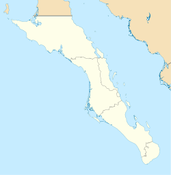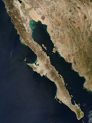
The Baja California peninsula is a peninsula in northwestern Mexico. It separates the Gulf of California from the Pacific Ocean. The peninsula extends from Mexicali, Baja California, in the north to Cabo San Lucas, Baja California Sur, in the south.

The Gulf of California, also known as the Sea of Cortés or Sea of Cortez, or less commonly as the Vermilion Sea, is a marginal sea of the Pacific Ocean that separates the Baja California Peninsula from the Mexican mainland. It is bordered by the states of Baja California, Baja California Sur, Sonora, and Sinaloa with a coastline of approximately 4,000 km (2,500 mi). Rivers that flow into the Gulf of California include the Colorado, Fuerte, Mayo, Sinaloa, Sonora, and the Yaqui. The surface of the gulf is about 160,000 km2 (62,000 sq mi). Maximum depths exceed 3,000 meters (9,800 ft) because of the complex geology, linked to plate tectonics.

Baja California Sur, officially Estado Libre y Soberano de Baja California Sur, is the least populated state and the 31st admitted state of the 32 federal entities which comprise the 31 States of Mexico. It is also the ninth-largest Mexican state in terms of area.
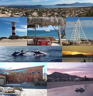
Bahía de los Ángeles is a coastal bay on the Gulf of California, located along the eastern shore of the Baja California Peninsula in the state of Baja California, Mexico. The town of the same name is located at the east end of Federal Highway 12 about 42 miles (68 km) from the Parador Punta Prieta junction on Federal Highway 1. The area is part of the San Quintín Municipality.

La Paz is the capital city of the Mexican state of Baja California Sur. The city had a 2020 census population of 250,141 inhabitants, making it the most populous city in the state. It is in La Paz Municipality, which is the fourth-largest municipality in Mexico in geographical size and reported a population of 292,241 inhabitants on a land area of 20,275 km2 (7,828 sq mi).
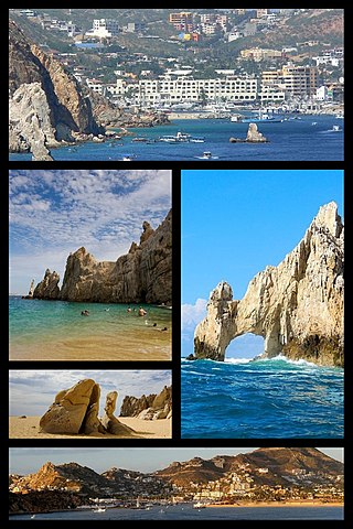
Cabo San Lucas, also known simply as Cabo, is a resort city at the southern tip of the Baja California peninsula, in the Mexican state of Baja California Sur. As of the 2020 Census, the population of the city was 202,694. Cabo San Lucas, together with the famous San José del Cabo are collectively known as Los Cabos. Together, they form a metropolitan area of 351,111 inhabitants.

Francisco de Ulloa was a Spanish explorer who explored the west coast of present-day Mexico and the Baja California Peninsula under the commission of Hernán Cortés. Ulloa's voyage was among the first to disprove the cartographic misconception of the existence of the Island of California.
The human history of the west coast of North America is believed to stretch back to the arrival of the earliest people over the Bering Strait, or alternately along a now-submerged coastal plain, through the development of significant pre-Columbian cultures and population densities, to the arrival of the European explorers and colonizers. The west coast of North America today is home to some of the largest and most important companies in the world, as well as being a center of world culture.

Sebastián Vizcaíno (1548–1624) was a Spanish soldier, entrepreneur, explorer, and diplomat whose varied roles took him to New Spain, the Baja California peninsula, the California coast and Asia.
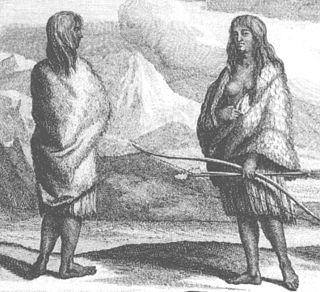
The Pericú were the aboriginal inhabitants of the Cape Region, the southernmost portion of Baja California Sur, Mexico. They have been linguistically and culturally extinct since the late 18th century.

San Felipe is a coastal city in San Felipe Municipality, Baja California, located on the Gulf of California. The population of San Felipe was reported as 17,143 inhabitants in the 2020 Mexican Census. San Felipe is historically a fishing town. Today it is also a popular tourist destination, known for its beaches, nature, and desert racing, as home to the San Felipe 250.

La Paz International Airport ; officially Aeropuerto Internacional Manuel Márquez de León(Manuel Márquez de León International Airport) is an international airport located in La Paz, Baja California Sur, Mexico, situated along the western shore of the Gulf of California. It serves as the primary air traffic gateway to the city of La Paz and is a focus city for the regional airline Calafia Airlines. The airport also accommodates military facilities for the Mexican Army and the Mexican Navy and supports various tourism, flight training, and general aviation activities. Grupo Aeroportuario del Pacífico owns and operates the airport, and it is named in honor of Manuel Márquez de León, a Mexican politician, military leader, and intellectual originally from this state. The airport served as the headquarters and hub for Aero California from its foundation in 1960 until its bankruptcy in 2006.

Los Cabos is a municipality located at the southern tip of Mexico's Baja California Peninsula, in the state of Baja California Sur. It encompasses the two towns of Cabo San Lucas and San José del Cabo linked by a thirty-two-km Resort Corridor of beach-front properties and championship golf courses.
San Antonio is a small town in La Paz Municipality in the Mexican state of Baja California Sur, located near El Triunfo on Federal Highway 1. It had a population of 463 inhabitants in the 2010 census, and is situated 400 meters (1,312 ft.) above sea level.

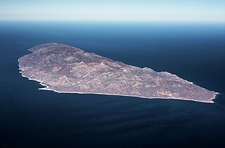
Isla Espíritu Santo is an uninhabited island in the Gulf of California, off the Mexican state of Baja California Sur. It is separated from Isla Partida by a narrow canal.
Isla Cerralvo, as is commonly named, whose official name is Isla Jacques Cousteau, is an island located off the Cerralvo Canal coast near La Paz, Baja California Sur, Mexico.

El Centenario is a small seaside town located in La Paz Municipality, Baja California Sur, Mexico, approximately 15 km west of La Paz, the capital city. El Centenario had a 2020 census population of 6,221 persons.

The Pacific Coast Campaign refers to United States naval operations against targets along Mexico's Pacific Coast during the Mexican–American War. It excludes engagements of the California Campaign in areas of The Californias north of the Baja California Peninsula. The objective of the campaign was to secure the Baja Peninsula of Mexico, and to blockade/capture west-coast ports of Mexico—especially Mazatlan, a major port-of-entry for imported supplies. The resistance of Mexican forces to the north in the Los Angeles area and the lack of ships, soldiers and logistical support prevented an early occupation of the peninsula and the west-coast Mexican seaports. The U.S. Navy attempted blockades of the ports three times before being able to successfully blockade and/or occupy them.
Isla San Francisco is a small island in Mexico located in the Gulf of California off the eastern coast of Baja California Sur, south of Isla San José. Uninhabited, the island is located in the southern portion of the Gulf of California, north of the Bay of La Paz, some 75 km (47 mi) north of the town of La Paz and is part of the La Paz Municipality. It is separated from the peninsula of Baja California by a channel about 10 km (6.2 mi) wide. The island is 2.5 km (1.6 mi) long and 2.5 km (1.6 mi) wide with maximum total area of 3.78 km2.
Harumi Fujita is a Japanese researcher of Mexican archaeology, who has specialized in pre-classical period of the northern states of Baja California and Baja California Sur. Her research has shown that fishing cultures had arisen in the area at the end of the Pleistocene period, indicating an occupation from at least 11,000 years ago. In a cave shelf known as the Babisuri Shelter, radiocarbon dating indicated the area may have been occupied 40,000 years ago.