Laage

Last updated
Laage
Laage Wasserturm.jpg
Laage Water tower
Laage-Wappen.PNG
Location of Laage within Rostock district
Laage in LRO.svg
Germany adm location map.svg
Red pog.svg
Laage
Mecklenburg-Vorpommern location map.svg
Red pog.svg
Laage
Coordinates: 53°55′56″N12°20′48″E / 53.93222°N 12.34667°E / 53.93222; 12.34667
Country Germany
State Mecklenburg-Vorpommern
District Rostock
Municipal assoc. Laage
Government
   Mayor Holger Anders
Area
  Total114.78 km2 (44.32 sq mi)
Elevation
20 m (70 ft)
Population
 (2021-12-31) [1]
  Total6,450
  Density56/km2 (150/sq mi)
Time zone UTC+01:00 (CET)
  Summer (DST) UTC+02:00 (CEST)
Postal codes
18299
Dialling codes 038459
Vehicle registration LRO
Website www.stadt-laage.de

Laage is a town in Rostock (district) in Mecklenburg-Vorpommern (Germany). It is situated on the river Recknitz, 23 kilometers southeast of Rostock.

Contents

Geography

Geographical location

Laage lies between the cities Güstrow, Teterow und Rostock on a natural ford along the Recknitz river.

To the west and east of the Recknitz-Urstromtal there are terminal moraines. Der Kalte Berg is 62m above the Normalhöhennull, the tallest point of elevation in the municipal area. Rostock Laage Airport is located a few kilometers west of Laage.

Municipal areas

The municipal area is made up of the city center Laage and the following areas: [2]

  • Alt Diekhof
  • Alt Rossewitz
  • Breesen
  • Diekhof
  • Drölitz
  • Jahmen
  • Klein Lantow
  • Knegendorf
  • Lissow
  • Lissow-Bau
  • Lüningsdorf
  • Pölitz

History

Name

In 1216 Laage was known as Lauena. The original polabian name changed to Lawe in 1257, and Laue in 1306, then again to Lawe, and finally to Lage in 1622, with the modern common spelling Laage becoming popular in 1726. The wendish Lave could be translated as footbridge or bridge; Laage then being known as the bridge-place over the flowing Recknitz. [3]

Early settlement

As early as the Mesolithic (around 8000 BCE) there were hunters, gatherers, and fishers settling the fertile area. Remains from the Neolithic period (around 4500 BCE to 1800 BCE) and the Bronze Age (1800 BCE to 70 BCE) have also been documented. [4] A burial mound near Goritz is an example of a discovery form the late Bronze Age. Prior to the departure of migrations, the region was inhabited by Germanic peoples.

Middle ages

In the early middle ages there was a slavonic castle and fortified settlement. Paths made out of planks and gravel, as well as Glacial erratics were created by the 6th century CE at the latest in order to traverse the Recknitz Valley. A total of five paths were discovered in 2015, the younger ones being dated between 719 and 830, and the youngest being dated to Old Slavic times. [5]

At the end of the 12the century, a German settlement took place, and Laage became a German castle at the crossing of the Recknitz. In 1216, Laage was first mentioned as a village. The town belonged to the Werle Fiefdom Fiefdom. In 1270, Laage was mentioned in a deed of donation by Prince Nicholas II of Werle. Laage was the seat of the de:Landvogt until around the 15th century. In the middle of the 13th century the construction of an early Gothic village church was started, the tower being completed in the 15th century. In 1309 (according to other sources 1271) Laage was named an Oppidum, thus having town privileges. The city developed through the important east-west connection of the via regia – the royal road from Wismar to Demmin – and a country road to Rostock. In the 14th century, Laage received a rampart with moat to protect it from robber knights. With the death of Prince Wilhelm the Wendish the principality of Werle died out, and the Dukes of Mecklenburg therefore inherited Laage. The town became a town in Mecklenburg  [ de ] and as such was one of the towns in the Wendische Kreis, which until 1918 were represented at the Mecklenburg Legislature, united in 1523  [ de ].

16th to 19th centuries

In 1569, a fire broke out in the town. Parts of the city, church, and town hall were subject to damage. In 1638, during the Thirty Years' War, imperial troops attacked Laage. This was followed by The Black Death, from which only five residents survived. Hardly recovered, the Great Northern War and the Seven Years' War followed, with many casualties requiring the quartering of soldiers. In 1712, Czar Peter the Great had his quarters in Laage. [6] In 1759, another town fire ensued, in which 63 houses and 24 barns burned down.

The city recovered from the wars. In 1768 it received a new city constitution, which was in force until 1918. Since then, there has been one mayor and two senators. The local governance consisted of a spokesperson, three viertelmann (a combination of mayor and policeman) and three deputies.

In 1692, a paper mill was built and in 1748 the Bockwindmill was built on the Bullenberg. In 1786, the first pharmacy was established by Chirurgus Hektor. Field Marshal Gebhard Leberecht von Blücher visited the city in 1814.

In 1829, Laage was better connected to the transport network with the construction of the Chaussee Rostock-Neubrandenburg. After the Gründerzeit, the village had a population of 2,345. The Amtsgericht and a paper mill were set up. It was followed in 1886 by a railway connection with Laage station west of the city center. In 1891, a voluntary fire brigade was founded. A dairy, the gas plant (1905), the waterworks and the water tower (1926) were built, and in 1915 the village received electric light.

Recent history

In the 1920s, new residential buildings were built, among others in the Paul-Lüth-Straße, the St. -Jürgen-Straße, Goethestraße and Breesener Straße. The sewerage system was also further expanded.

On May 1, 1945, the Red Army invaded Laage. The day before, local Social Democrats had dismantled the tank barriers erected for the defense. The acting mayor, Otto Thode, [7] met the Soviet troops and prevented destruction in Laage. [8]

Shortly after the invasion of the Red Army, on 2 May 1945, the well-known architect de:Paul Korff took his own life together with his wife. Otto Thode also chose suicide with his wife and daughter on that day. They were buried in communal graves at the Laager Cemetery.

After the Second World War, the number of inhabitants doubled due to the influx of refugees.

At the end of 1945 and the beginning of 1946, ten young people (aged 16 and over) were arrested by the Soviet secret service NKVD and sentenced by a military tribunal to heavy prison terms for “hostile attitudes towards Communism and the Red Army”. Seven of them died in the Soviet special camp Sachsenhausen. The group was rehabilitated in 1993 by the Prosecutor General's Office of the Russian Federation. [9]

The milk sugar factory resumed production in 1946. Agricultural production cooperatives were established around 1950, and the Volkseigenes Gut was important. An outdoor swimming pool was built and in 1967 a second school was built on the new sports ground. The Breesener Straße Hospital became a rural ambulatory.

Around 1980, the military airfield was built. The Fighter Bomber Squadron 77 and the Marine Squadron 28 of the National People's Army (NVA) had been stationed at this military airfield since 1984 with Sukhoi Su-22 aircraft until the dissolution of the NVA. From 1979 to 1988, the Kronskamp residential area was built with 850 apartments in Large panel system-building, among other things for the soldiers stationed in Laage. A third school also had to be built.

Saniertes Fachwerkhaus Laage Strasse des Friedens 9.JPG
Saniertes Fachwerkhaus
Flughafen Rostock-Laage Laage Flughafen Eingang.jpg
Flughafen Rostock-Laage

Since 1991, the historical town centre with its town hall and a little later the only remaining de:Scheunenviertel in Mecklenburg were fundamentally renovated as part of the urban development funding. The slab construction area has also been significantly improved since 1998 by demolition and upgrading measures.

The military airfield is operated by Jagdgeschwader 73 "Steinhoff" of the Bundeswehr and was expanded after 1994 in parallel to the civil airport Rostock-Laage. In 2018, around 290,000 passengers used the airport.

From 1952 to 2011 Laage belonged to the district of Güstrow (GDR-Bezirk Schwerin / State of Mecklenburg-Vorpommern) and since then is part of the district of Rostock.

History of municipal areas

Rossewitz: There was a castle here in the Middle Ages. Owner of the estates included the noble families Nortman (until 1450) and von Vieregg (until 1760), after which it was a ducal chamberlain. The early Baroque manor house Rossewitz was built on the foundations of the castle according to plans by Charles Philippe Dieussart between 1657 and 1680. It is considered to be the first Baroque building in Mecklenburg. Grand Duke Frederick Franz I lived in the castle several times. After 1945 it was a shelter for refugees. The roof collapsed in 1982, and an emergency roof was erected in 1986. Renovation work has taken place since 1993.

Schweez is a manor village and was owned by the families of Hahn (until 1771), Reichgrave von Wallmoden-Gimborn (until 1845), Count von Bassewitz (until 1913) and Count von Schlieffen.

Weitendorf: The church dates from the 13th century, the upper baroque tower from the 18th century, and the baroque park from 1763.

Incorporation

On 1 July 1950, the formerly independent communities of Breesen and Kronskamp were incorporated. Liessow was incorporated into the city of Laage on 13 June 2004, [10] Weitendorf on 1 July 2006 [11] and Diekhof on 26 May 2019. [12]

Population

YearResidents
16375
170666
1756513
1813925
18501828
18852345
19002548
19392924
19843884
YearResidents
19906295
19956042
20005223
20055119
20105591
20155403
YearResidents
20206477
20216450
20226549

From 1990 onwards, 31 December of each year [13]

The stark increase in the population in 2019 is due to the incorporation of Diekhof.

Politics

Municipal elections

Following the municipal elections on 26 May 2019, the municipal council of Laage is composed of the mayor and 19 city representatives: [14]

Party / List CDU Laage Electorate Die Linke FDP Diekhof Electorate SPD Total
Seats73322219
Share of the vote35,7 %16,4 %14,4 %12,6 %11,1 %9,8 %100%
Rathaus Am Markt 7.JPG

Mayor

Anders was elected in the mayoral run-off election on 8 October 2017 with 50.9% of the valid votes. [15] He remained in office until his death in September 2023. [16]

Coat of arms

Coat of arms of Laage
Laage-Wappen.PNG
Notes
Coat of Arms of the City of Laage. In gold a visionary black bull's head with a closed mouth, a beaten red tongue, between whose silver horns a red lily grows.
Symbolism
The coat of arms, designed after the seal image of the SIGILLVM CIVITATIS LAWE – first handed down as a print in 1353, and laid down in its current form in April 1858, points with the bull head typical of the Werl line of the Mecklenburg princely house to Herr zu Werle as the city's founder and lord. As the meaning of the lily is largely unclear, over time it disappeared from the city's seal paintings.

Flag

The flag was approved by the Ministry of Interior on 4 April 2016.

The flag consists of a yellow cloth and is covered in the centre with the figure of the city's coat of arms, which occupies two thirds of the height of the flag cloth: a visionary black bull's head with a closed mouth and a knocked out red tongue, between whose silver horns a red lily grows. The height of the flag cloth is related to the length as 3:5. [17]

Seal of office

The official seal shows the city coat of arms with the inscription • STADT LAAGE •. [17]

Places of interest

Stadtkirche Kirche in Laage.JPG
Stadtkirche
Herrenhaus Rossewitz Schloss-Rossewitz-Seitenansicht.jpg
Herrenhaus Rossewitz

Transportation

Laage is located along the Bundesstraßen B 103 to Güstrow and B 108 to Teterow along with the Landesstraßen L 18 to Tessin and the L 39 to Rostock.

The Laage (Meckl) station sits on the Neustrelitz–Warnemünde railway. The Rostock S-Bahn S3 line runs through here from RostockGüstrow.

West of the city is the Rostock–Laage Airport.

Notable people

Söhne und Töchter of the city

With a personal connection to Laage

Bibliography

Related Research Articles

<span class="mw-page-title-main">Mecklenburg-Vorpommern</span> State in Germany

Mecklenburg-Vorpommern ; also known by its anglicized name Mecklenburg–Western Pomerania, is a state in the north-east of Germany. Of the country's sixteen states, Mecklenburg-Vorpommern ranks 14th in population; it covers an area of 23,213 km2 (8,963 sq mi), making it the sixth largest German state in area; and it is 16th in population density. Schwerin is the state capital and Rostock is the largest city. Other major cities include Neubrandenburg, Stralsund, Greifswald, Wismar, and Güstrow. It was named after the two regions of Mecklenburg and Vorpommern, and its name means the "nearer part of Pomerania", with the rest now lying in Poland.

<span class="mw-page-title-main">Wismar</span> City in Mecklenburg-Vorpommern, Germany

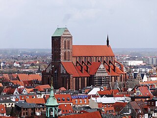
Wismar, officially the Hanseatic City of Wismar is, with around 43,000 inhabitants, the sixth-largest city of the northeastern German state of Mecklenburg-Vorpommern, and the fourth-largest city of Mecklenburg after Rostock, Schwerin and Neubrandenburg. The city was the third-largest port city in former East Germany after Rostock and Stralsund.

<span class="mw-page-title-main">Rostock</span> Largest city in Mecklenburg-Vorpommern, Germany

Rostock officially the Hanseatic and University City of Rostock, is the largest city in the German state of Mecklenburg-Vorpommern and lies in the Mecklenburgian part of the state, close to the border with Pomerania. With around 210,000 inhabitants, it is the third-largest city on the German Baltic coast after Kiel and Lübeck, the eighth-largest city in the area of former East Germany, as well as the 39th-largest city of Germany. Rostock was the largest coastal and most important port city in East Germany.

<span class="mw-page-title-main">Güstrow</span> Town in Mecklenburg-Vorpommern, Germany

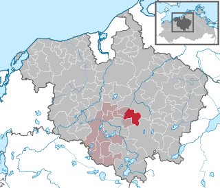
Güstrow is a town in Mecklenburg-Vorpommern in north-eastern Germany. It is capital of the Rostock district; Rostock itself is a district-free city and regiopolis.

<span class="mw-page-title-main">Neustrelitz</span> Town in Mecklenburg-Vorpommern, Germany

Neustrelitz is a town in the Mecklenburgische Seenplatte district in the state of Mecklenburg-Vorpommern, Germany. It is situated on the shore of the Zierker See in the Mecklenburg Lake District. From 1738 until 1918 it was the capital of the Duchy of Mecklenburg-Strelitz. From 1994 until 2011 it was the capital of the district of Mecklenburg-Strelitz.

<span class="mw-page-title-main">Ribnitz-Damgarten</span> Town in Mecklenburg-Vorpommern, Germany

Ribnitz-Damgarten is a town in Mecklenburg-Vorpommern, Germany, situated on Lake Ribnitz. Ribnitz-Damgarten is in the west of the district Vorpommern-Rügen.

<span class="mw-page-title-main">Rostock–Laage Airport</span> Airport

Rostock Airport, German: Flughafen Rostock-Laage, is the airport of Rostock, the largest city in the German state Mecklenburg-Vorpommern, and is named after Laage, within the boundary of which it is located. Laage is a town in the Rostock district. It features flights to major cities throughout Germany as well as some leisure routes. In addition to civil activity, Jagdgeschwader 73 of the German Air Force is stationed on the military side of the airport.

<span class="mw-page-title-main">Schwaan</span> Town in Mecklenburg-Vorpommern, Germany

Schwaan is a municipality in the Rostock district, in Mecklenburg-Vorpommern, Germany. It is also the seat of the Schwaan Township, serving another six municipalities.

<span class="mw-page-title-main">Tessin, Germany</span> Town in Mecklenburg-Vorpommern, Germany

Tessin is a town in the Rostock district, in Mecklenburg-Western Pomerania, Germany. It is situated on the river Recknitz, 22 km east of Rostock.

<span class="mw-page-title-main">Plaaz</span> Municipality in Mecklenburg-Vorpommern, Germany

Plaaz is a municipality in the Rostock district, in Mecklenburg-Vorpommern, Germany. It is situated close to the cities Güstrow, Laage and Teterow. Plaaz includes several villages such as Mierendorf, Wendorf and Zapkendorf. As of January 2005, both Spoitgendorf and Recknitz are incorporated in this municipality.

<span class="mw-page-title-main">Dettmannsdorf</span> Municipality in Mecklenburg-Vorpommern, Germany

Dettmannsdorf is a municipality in the Vorpommern-Rügen district, in Mecklenburg-Vorpommern, Germany. The municipality is located south-west of Ribnitz-Damgarten in the Recknitz valley. Until January 1, 1999, it belonged to Amt Trebeltal and now belongs to Amt Recknitz-Trebeltal.

<span class="mw-page-title-main">Neustrelitz–Warnemünde railway</span>

The Neustrelitz–Warnemünde Railway is a railway line in the North German state of Mecklenburg-Vorpommern. Most of the line is a double-tracked, electrified main line and runs for almost 130 kilometres from Neustrelitz to Warnemünde. It is also known in German as the Lloydbahn, referring to the Deutsch-Nordischer Lloyd company, which built the line and operated it in its early years after its opening in 1886.

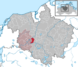
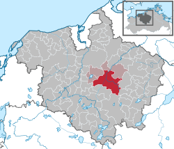
Rostock is a district in the north of Mecklenburg-Vorpommern, Germany. It is bounded by the district Nordwestmecklenburg, the Baltic Sea, the district-free city Rostock and the districts Vorpommern-Rügen, Mecklenburgische Seenplatte and Ludwigslust-Parchim. The district seat is the town Güstrow.

The region of Middle Mecklenburg represents that area of the German state of Mecklenburg-Vorpommern with the most developed infrastructure in a state that is otherwise rather underdeveloped structurally. Middle Mecklenburg includes the largest urban centre in the state, the Hanseatic city of Rostock with its 200,000 inhabitants together with the surrounding district of the same name. The most important river in the region is the Warnow. Its transport links radiate from Rostock in a star configuration and the metropolitan region of the port city is served by a public transport network that includes the Rostock S-Bahn. Other important centres are the county towns of Bad Doberan and Güstrow. The main tourist attraction is the Baltic Sea coast along the Bay of Mecklenburg with the Salzhaff, the sea cliffs and the seaside resorts of Rerik, Kühlungsborn, Heiligendamm, Warnemünde and Graal-Müritz. In the south Middle Mecklenburg transitions into the naturally very unspoilt region of the Mecklenburg Lake District. In the east the River Recknitz forms its boundary with West Pomerania, in the west it merges gradually into West Mecklenburg.

Kyra T. Inachin was a German historian.

<span class="mw-page-title-main">Rostock S-Bahn</span>

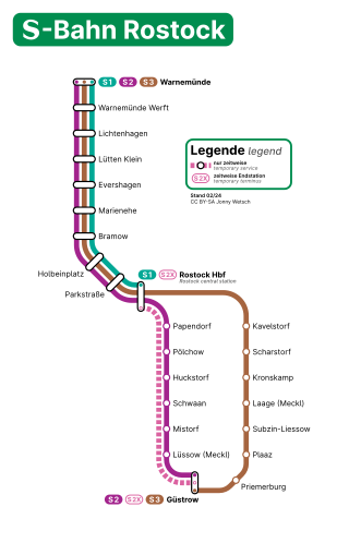
The Rostock S-Bahn is a S-Bahn network in Rostock in the German state of Mecklenburg-Vorpommern. It consists of three lines with a total length of about 90 km. Line S1 runs from Rostock Hauptbahnhof to Warnemünde within the Rostock urban area. S-Bahn operations started on 28 September 1974. Later, the lines to the north-east to the port (Seehafen) of Rostock and to the south to the town of Güstrow via Schwaan were included in the S-Bahn network. The line to the port was discontinued in 2012, but at same time the line to Güstrow via Laage was included as line S3 of the S-Bahn. Until 2014 the rolling stock mainly consisted of push–pull trains with Waggonbau Görlitz double-deck coaches. Since then all lines have been operated with new Bombardier Talent 2 railcars.

<span class="mw-page-title-main">Otto Piper</span>

Otto Piper (1841–1921) was a German architectural historian who, with August von Cohausen (1812–1896), is regarded as one of the two founders of scientific research into castles.

Paul Wallat was a German landscape artist, draftsman and sculptor.

Michael Buddrus is a German historian.

<span class="mw-page-title-main">Max Samuel</span>

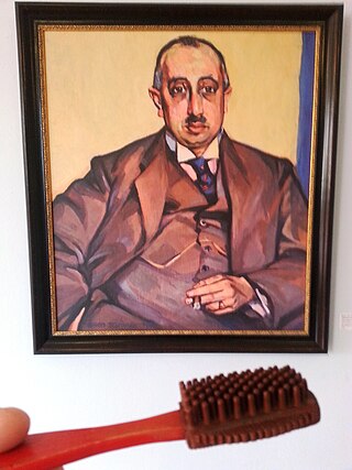
Max Samuel was a German businessman and self-made man, founder and managing-director of the EMSA-Werke, chair of the Jewish congregation in Rostock and head deputy of the Israelite Upper Council of Mecklenburg-Schwerin.

References

  1. "Bevölkerungsstand der Kreise, Ämter und Gemeinden 2021" (XLS) (in German). Statistisches Amt Mecklenburg-Vorpommern. 2022.
  2. Hauptsatzung der Stadt Laage
  3. Ernst Eichler und Werner Mühlmer: Die Namen der Städte in Mecklenburg-Vorpommern. Ingo Koch Verlag, Rostock 2002, ISBN 3-935319-23-1
  4. Monika Riek: Laage und Umgebung. Edition Temmen, Bremen 1998, ISBN 3-86108-433-3.
  5. J.-P. Schmidt: Feste Wege über die Flussniederung, in: Archäologie in Deutschland, Heft 1 (2016), S. 46.
  6. Alexander Querengässer: Das kursächsische Militär im Großen Nordischen Krieg 1700–1717. Verlag Ferdinand Schöningh, Paderborn 2019, S. 465.
  7. Michael Buddrus, Sigrid Fritzlar: Die Städte Mecklenburgs im Dritten Reich. Edition Temmen, 2011, ISBN 978-3-8378-4029-2.
  8. Anja Hauffe: Zur Lebenssituation in der Stadt Laage in den Jahren 1945 und 1946. (unveröffentlichte Hausarbeit zur Ersten Staatsprüfung für das Lehramt an Gymnasien, 15-A-GUE)
  9. Benno Prieß: Erschossen im Morgengrauen. (Mitherausgeber: Landesbeauftragte für die Unterlagen des Staatssicherheitsdienstes der DDR) Eigenverlag, Calw 2002, ISBN 3-926802-36-7. S. 203–207.
  10. StBA: Änderungen bei den Gemeinden Deutschlands, siehe 2004
  11. StBA: Änderungen bei den Gemeinden Deutschlands, siehe 2006
  12. Bekanntmachung des Ministeriums für Inneres und Europa vom 16. Januar 2019, AmtsBl. M-V, S. 254
  13. Archived (Date missing) at laiv-mv.de (Error: unknown archive URL)
  14. "Bekanntmachung des Wahlergebnisses zur Wahl der Stadtvertretung in der Stadt Laage am 26. Mai 2019" (PDF; 1,3 MB). Stadt Laage. 2019-05-26. Retrieved 2019-12-11.
  15. Holger Anders erobert Laage. In: Schweriner Volkszeitung. 8. Oktober 2017 (svz.de).
  16. Laage trauert um Bürgermeister Holger Anders. In: Schweriner Volkszeitung , 25. September 2023.
  17. 1 2 Hauptsatzung § 2 (PDF; 4,1 MB).