
Luzerne County is a county in the Commonwealth of Pennsylvania. According to the U.S. Census Bureau, the county has a total area of 906 square miles (2,350 km2), of which 890 square miles (2,300 km2) is land and 16 square miles (41 km2) is water. It is Northeastern Pennsylvania's second-largest county by total area. As of the 2010 census, the population was 320,918, making it the most populous county in the northeastern part of the state. The county seat and largest city is Wilkes-Barre. Other populous communities include Hazleton, Kingston, Nanticoke, and Pittston. Luzerne County is included in the Scranton–Wilkes-Barre–Hazleton Metropolitan Statistical Area, which has a total population of 555,426.

Berwick is a borough in Columbia County, Pennsylvania, United States, 28 miles (45 km) southwest of Wilkes-Barre. As of the 2010 census, Berwick had a population of 10,477. It is one of the two principal communities of the Bloomsburg-Berwick, PA Metropolitan Statistical Area, a metropolitan area that covers Columbia and Montour counties, and had a combined population of 85,562 at the 2010 census.

Duryea is a borough in the Greater Pittston area of Luzerne County, Pennsylvania, United States, 9 miles (14 km) south of Scranton. It is situated along the eastern bank of the Susquehanna. The Lackawanna River runs through the heart of Duryea's boundary. It was incorporated as a borough in 1901, and had an import switching rail yard, the Duryea yard, connecting the central Wyoming Valley to destinations in lower New York and down-state Pennsylvania. Coal mining and the manufacturing of silk were the chief industries in the early years of its existence. The population was 4,917 at the 2010 census.

Kingston is a borough in Luzerne County, Pennsylvania, United States. It is located on the western bank of the Susquehanna River opposite Wilkes-Barre City. Kingston was first settled in the early 1770s; it was later incorporated as a borough in 1857. As of the 2010 census, the population was 13,182, making it the most populous borough in the county.

Pittston is a city in Luzerne County, Pennsylvania, United States. It is situated between Scranton and Wilkes-Barre. The city gained prominence in the late 19th and early 20th centuries as an active anthracite coal mining city, drawing a large portion of its labor force from European immigrants. The population was 7,739 as of the 2010 census, making it the fourth largest city in Luzerne County. At its peak in 1920, the population of Pittston was 18,497. The city consists of three sections: The Downtown, the Oregon Section, and the Junction. Pittston City is at the heart of the Greater Pittston region. Greater Pittston has a total population of 48,020.

Pittston Township is a township in Luzerne County, Pennsylvania, United States. The population was 3,368 as of the 2010 census. The township is located within the Greater Pittston region. As of 2010, the total population of Greater Pittston was 48,020. The Wilkes-Barre/Scranton International Airport is located in Pittston Township.

The Lackawanna River is a 42-mile-long (68 km) tributary of the Susquehanna River in northeastern Pennsylvania in the United States. It flows through a region of the northern Pocono Mountains that was once a center of anthracite coal mining in the United States. It starts in north Wayne County, Pennsylvania and ends in east Luzerne County, Pennsylvania in Duryea, Pennsylvania. The lower reaches of the river flow through the urban areas of Scranton, which grew around its banks in the 19th century as an industrial center. Its name comes from a Lenni Lenape word meaning "stream that forks".
Lackawanna is the name of various places and later businesses in the mid-Atlantic United States, generally tracing their name in some manner from the Lackawanna River in Pennsylvania.

The Delaware, Lackawanna and Western Railroad was a U.S. Class 1 railroad that connected Buffalo, New York, and Hoboken, New Jersey, a distance of about 400 miles (640 km). Incorporated in Pennsylvania in 1853 primarily for the purpose of providing a connection between the anthracite coal fields of Pennsylvania's Coal Region and the large markets for coal in New York City, the railroad gradually expanded both East and West, eventually linking Buffalo with New York City. Like most coal-focused railroads in Northeastern Pennsylvania, the DL&W was profitable during the first half of the twentieth century, but its margins were gradually hurt by declining Pennsylvania coal traffic, especially following the 1959 Knox Mine Disaster and competition from trucks following the expansion of the Interstate Highway System in the 1960s and 1970s. In 1960, the DL&W merged with rival Erie Railroad to form the Erie Lackawanna Railroad that would be taken over by Conrail in 1976.

Northeastern Pennsylvania (NEPA) is a geographic region of the U.S. state of Pennsylvania that includes the Pocono Mountains, the Endless Mountains, and the industrial cities of Scranton, Wilkes-Barre, Pittston, Hazleton, Nanticoke, and Carbondale. A portion of this region constitutes a part of the New York City metropolitan area.
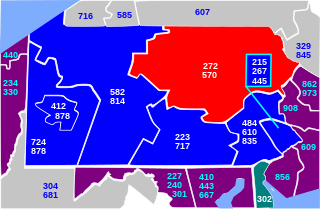
Area codes 570 and 272 are telephone area codes serving the northeast quadrant of Pennsylvania, including the cities/towns of Scranton, Wilkes-Barre, Williamsport, Stroudsburg, East Stroudsburg, Pittston, Carbondale, Hazleton, Clarks Summit, Towanda, Bloomsburg, Sayre, Tunkhannock, Berwick, Milford, Montrose, Honesdale, Pocono Pines, Nanticoke, Tamaqua, Shavertown, Dallas, Mahanoy City, Sunbury, Jim Thorpe, as far south as Pottsville and as far west as Lock Haven. 570 is the main area code, while 272 is an overlay covering the same territory as 570.

The North Shore Railroad is a short line railroad that operates 44 miles (71 km) of track in Northumberland, Montour, Columbia, and Luzerne counties in Pennsylvania in the United States. The line runs generally northeast between Northumberland and the unincorporated village of Beach Haven in Salem Township.

The Reading Blue Mountain and Northern Railroad, sometimes shortened to Reading and Northern Railroad, is a regional railroad operating in eastern Pennsylvania, with headquarters located in Port Clinton. The RBMN provides freight service on 300 miles (480 km) of track, with its mainline consisting of the Reading Division between Reading and Packerton and the Lehigh Division between Lehighton and Dupont. In addition to freight service, passenger excursions also run along the RBMN system. The Lehigh Gorge Scenic Railway (LGSR) is a tourist railroad that operates passenger excursions along the RBMN between Jim Thorpe and Lehigh Gorge State Park. The RBMN also operates passenger excursions from Reading and Port Clinton to Jim Thorpe.
Geographic regions of the Commonwealth of Pennsylvania, United States of America.

Greater Pittston is a 65.35 sq mi (169.25 km²) region in Luzerne County, Pennsylvania, in reference to the area in and around Pittston. As of 2010, the total population of Greater Pittston is 48,020. This region includes Avoca, Dupont, Duryea, Exeter Boro, Exeter Township, Hughestown, Jenkins Township, Laflin, Pittston Township, West Pittston, West Wyoming, Wyoming, and Yatesville.

The Sunbury Line is a rail line that is owned and operated by Norfolk Southern Railway which in turn is owned by the Norfolk Southern Corporation. The line travels from Sunbury, Pennsylvania, to Binghamton, New York, connecting with Norfolk Southern's Southern Tier Line at Binghamton and Norfolk Southern's Buffalo Line at Sunbury.

The Central New York Railroad is a shortline railroad operating local freight service along ex-Southern Tier Line trackage in the U.S. states of New York and Pennsylvania. The line begins at Port Jervis, following the Delaware River to Deposit and the Susquehanna River from Lanesboro, where it crosses the Starrucca Viaduct, to Binghamton. It is a subsidiary of the Delaware Otsego Corporation, which also owns the New York, Susquehanna and Western Railway, operator of through trains over the line.
U.S. Route 11 (US 11) roughly parallels Interstate 81 (I-81) in the U.S. state of Pennsylvania. It serves Harrisburg and Scranton. Between those two cities, US 11 follows the Susquehanna River, while I-81 follows a shorter route over the mountains.
The Luzerne and Susquehanna Railway is a shortline railroad in Luzerne County, Pennsylvania. It both serves local traffic and connects to the Reading Blue Mountain and Northern Railroad in Pittston and to the Norfolk Southern Railway at three separate junctions. It operates a total of 55 miles of track in and around the Wyoming Valley in Luzerne County.
Red Spring Run is a tributary of the Lackawanna River in Lackawanna County and Luzerne County, in Pennsylvania in the United States. It is approximately 1.5 miles (2.4 km) long and flows through Ransom Township in Lackawanna County and Duryea in Luzerne County. The watershed of the stream has an area of 1.25 square miles (3.2 km2). It is designated as a Coldwater Fishery and a Migratory Fishery. The stream has one unnamed tributary. Many reaches of the stream have been affected by mining and abandoned mines. The surficial geology in its vicinity features alluvium, coal dumps, surface mining land, and Wisconsinan Till.

