The river Ticino is the most important perennial left-bank tributary of the Po. It has given its name to the Swiss canton through which its upper portion flows.

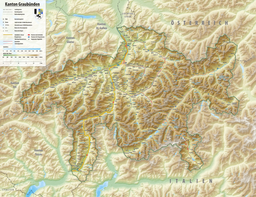
The Grisons or Graubünden, more formally the Canton of the Grisons or the Canton of Graubünden, is one of the twenty-six cantons of Switzerland. It has eleven districts, and its capital is Chur. The German name of the canton, Graubünden, translates as the "Grey Leagues", referring to the canton's origin in three local alliances, the Three Leagues. The other native names also refer to the Grey League: Grischùn in Sutsilvan, Grischun in the other forms of Romansh, and Grigioni in Italian. Rhaetia is the Latin name for the area. The Alpine ibex is the canton's heraldic symbol.
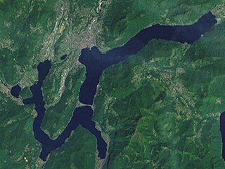
Lake Lugano is a glacial lake which is situated on the border between southern Switzerland and northern Italy. The lake, named after the city of Lugano, is situated between Lake Como and Lago Maggiore. It was cited for the first time by Gregory of Tours in 590 with the name Ceresio, a name which is said to have derived from the Latin word cerasus, meaning cherry, and refers to the abundance of cherry trees which at one time adorned the shores of the lake. The lake appears in documents in 804 under the name Laco Luanasco.

The Swiss National Park is located in the Western Rhaetian Alps, in eastern Switzerland. It lies within the canton of Graubünden, between Zernez, S-chanf, Scuol, and the Fuorn Pass in the Engadin valley on the border with Italy. Founded in 1914, the Swiss National Park is the oldest national park in the alps and in Central Europe.

The Vorderrhein, or Anterior Rhine, is the left of the two initial tributaries of the Rhine. It is longer than the Hinterrhein, but has a lower discharge than the latter at their confluence, which marks the beginning of the Alpine Rhine section.

Lago di Poschiavo is a natural lake in the Val di Poschiavo in the Swiss canton of the Grisons.

The Valle Verzasca is a valley in the Locarno district of the canton of Ticino, Switzerland. It comprises the municipalities of Mergoscia, Vogorno, Corippo, Lavertezzo, Brione, Gerra, Frasco, and Sonogno. As of 2004, the total population is 3,200. It is the most central valley of Ticino, and none of the passes out of the valley cross cantonal or national borders. The valley is formed by the river Verzasca and is situated between the Leventina and the Maggia and culminates at Pizzo Barone.

Lago di Cama is a lake in the Cama valley, a side valley of Val Mesolcina in the Grisons, Switzerland.

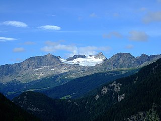
Palü Lake is a lake below Piz Palü in the Swiss canton of Graubünden. It has an elevation of 1,923 m (6,309 ft) and a surface area of 5.2 ha. Water from Palü Glacier feeds into the lake.
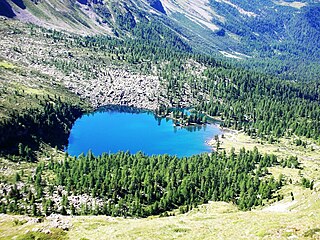
Lago di Val Viola is a lake in the Grisons, Switzerland. The lake is located near Lago di Saoseo, in the Poschiavo region.

Lägh da Cavloc is a lake near Maloja Pass in the Val Forno, Grisons, Switzerland.

Val Poschiavo is a valley in the southern, Italian-speaking part of the Swiss canton of the Grisons. The main town is Poschiavo.
Cima da Lägh is a mountain in the Oberhalbstein Range of the Alps, located on the border between Italy and Switzerland. On its southern side it overlooks the Val Bregaglia.
Sfazù is a hamlet in the upper part of the Val Poschiavo in the canton of Graubünden, Switzerland. It lies at 1,622 metres (5,322 ft) above sea level at the point where the Val da Camp enters the Val Poschiavo. It is on the southern approach to the Bernina Pass, and is in the municipality of Poschiavo, some 7.5 kilometres (4.7 mi) north of the village of the same name. Because of the 600 metres (2,000 ft) of altitude difference between the two villages, the distance between them by road is 9 kilometres (5.6 mi), using Hauptstrasse 29 that passes close by Sfazù.

Lägh da Bitabergh is a lake near Maloja Pass in Val Bregaglia, Grisons, Switzerland.

Lagh Doss is a lake at San Bernardino in the Val Mesolcina of the Grisons, Switzerland. It is located at an elevation of 1652 m. The site is listed in the Federal Inventory of Raised and Transitional Bogs of National Importance.

The Cinque Vette Park is a natural park, established by the Region of Lombardy on 19 June 2017. The park is located in the north-eastern part of the Province of Varese, in the Italian region of Lombardy. It takes the name from the main geographic features located in the park, the five mountain peaks. The project was launched with the aim of the three local councils of to preserve a green area and make it available for touristic-sportive-cultural initiatives above 500 meters of altitude. The primary goal of the park is to encourage the discovery of the natural features of the north-eastern part of Varese, which offers panoramic view points and preserves historical aspects such as: the remains of the Cadorna Line; the ruins of the Castle of Cuasso al Monte; the Artistic village of Boarezzo; the Saint Gemolo Abbey; the Alpine Village of Mount Piambello; and, the Hospital of Cuasso Al Monte.

Val Forno is a valley south of Maloja in the Swiss canton of Grisons with the Forno Glacier at the head of the valley.

Lac de la Bayenna is a mountain lake in the Val de Moiry, a side valley of the Val d'Anniviers, on the territory of the municipality of Anniviers in the Swiss canton of Valais. It lies at 2,546 m (8,353 ft) west of Lac de Châteaupré above the glacier forelands of Moiry Glacier. Its outlet flows into the Gougra river after about 800 m slightly below Lac de Châteaupré.

Guggisee is a mountain lake in the Lötschental in the canton of Valais in Switzerland. The lake is located at an altitude of 2,007 m (6,585 ft) near the Alp Guggistafel.