The river Ticino is the most important perennial left-bank tributary of the Po. It has given its name to the Swiss canton through which its upper portion flows.

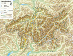
The Grisons or Graubünden, more formally the Canton of the Grisons or the Canton of Graubünden, is one of the twenty-six cantons of Switzerland. It has eleven districts, and its capital is Chur. The German name of the canton, Graubünden, translates as the "Grey Leagues", referring to the canton's origin in three local alliances, the Three Leagues. The other native names also refer to the Grey League: Grischùn in Sutsilvan, Grischun in the other forms of Romansh, and Grigioni in Italian. Rhaetia is the Latin name for the area. The Alpine ibex is the canton's heraldic symbol.
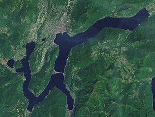
Lake Lugano is a glacial lake which is situated on the border between southern Switzerland and northern Italy. The lake, named after the city of Lugano, is situated between Lake Como and Lago Maggiore. It was cited for the first time by Gregory of Tours in 590 with the name Ceresio, a name which is said to have derived from the Latin word cerasus, meaning cherry, and refers to the abundance of cherry trees which at one time adorned the shores of the lake. The lake appears in documents in 804 under the name Laco Luanasco.

The province of Brescia is a province in the Lombardy region of Italy. It has a population of some 1,265,964 and its capital is the city of Brescia.

Val Camonica or Valcamonica, also Valle Camonica and anglicized as Camonica Valley, is one of the largest valleys of the central Alps, in eastern Lombardy, Italy. It extends about 90 kilometres (56 mi) from the Tonale Pass to Corna Trentapassi, in the commune of Pisogne near Lake Iseo. It has an area of about 1,335 km2 (515 sq mi) and 118,323 inhabitants. The River Oglio runs through its full length, rising at Ponte di Legno and flowing into Lake Iseo between Pisogne and Costa Volpino.

The Giudicarie Line is a major geologic fault zone in the Italian Alps, named for the Giudicarie valleys area. It runs from Meran in the northeast more or less straight along the lower part of the Val di Sole, along the Val Rendena and then along the Chiese valley to the Lago d'Idro.

Valdidentro is a comune (municipality) in the Province of Sondrio in the Italian region Lombardy, located about 140 kilometres (87 mi) northeast of Milan and about 50 kilometres (31 mi) northeast of Sondrio, in the upper Alta Valtellina on the border with Switzerland.

Lago di Poschiavo is a natural lake in the Val di Poschiavo in the Swiss canton of Graubünden.

The Toce is a river in Piedmont, Italy, which stretches the length of the Val d'Ossola from the Swiss border to Lake Maggiore into which it debouches near Fondotoce in the commune of Verbania. The river is 83.6 kilometres (51.9 mi) long and is formed in the upper Val Formazza by the confluence of a number of torrents in the plain of Riale.

The Geography of Piedmont is that of a territory predominantly mountainous, 43.3%, but with extensive areas of hills which represent 30.3% of the territory, and of plains (26.4%).

The Chiese, also known in the Province of Brescia as the Clisi, is a 160-kilometre (99 mi) Italian river that is the principal immisary and sole emissary of the sub-alpine lake Lago d’Idro, and is a left tributary of the Oglio.

Lago Bianco is a reservoir at the Bernina Pass in the Swiss canton of Graubünden.

Lago di Cama is a lake in the Cama valley, a side valley of Val Mesolcina in the Grisons, Switzerland.

Lago di Saoseo is a lake in the Val da Camp, a valley in the Poschiavo region of the Grisons, Switzerland.

Lägh da Cavloc is a lake near Maloja Pass in the Val Forno, Grisons, Switzerland.

Val Poschiavo is a valley in the southern, Italian-speaking part of the Swiss canton of Graubünden (Grisons). The main town is Poschiavo.

Bacino di Val Malvaglia is a lake above Malvaglia in the canton of Ticino, Switzerland. The reservoir's surface area is 0.19 km2. Its arch dam was built in 1959 and is operated by Officine Idroelettriche di Blenio SA (Ofible).

The Garda Mountains, occasionally also the Garda Hills, are an extensive mountain range of the Southern Limestone Alps in northern Italy.

The border between the modern states of Switzerland and Italy extends for 744 kilometres (462 mi), from the French-Swiss-Italian tripoint at Mont Dolent in the west to the Austrian-Swiss-Italian tripoint near Piz Lad in the east. Much of the border runs across the High Alps, rising above 4,600 metres (15,100 ft) as it passes east of Dufourspitze, but it also descends to the lowest point in Switzerland as it passes Lago Maggiore at below 200 metres (660 ft).