The Azores officially the Autonomous Region of the Azores, is one of the two autonomous regions of Portugal. It is an archipelago composed of nine volcanic islands in the Macaronesia region of the North Atlantic Ocean, about 1,400 km (870 mi) west of Lisbon, about 1,500 km (930 mi) northwest of Morocco, and about 1,930 km (1,200 mi) southeast of Newfoundland, Canada.

Portugal is a coastal nation in western Europe, located at the western end of the Iberian Peninsula, bordering Spain. The Portuguese territory also includes a series of archipelagos in the Atlantic Ocean, which are strategic islands along the North Atlantic. The extreme south is not too far from the Strait of Gibraltar, leading to the Mediterranean Sea. In total, the country occupies an area of 92,090 square kilometres (35,560 sq mi) of which 91,470 square kilometres (35,320 sq mi) is land and 620 square kilometres (240 sq mi) water.
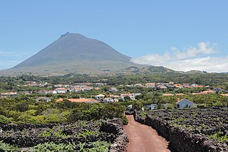
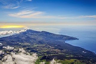
Pico Island is an island in the Central Group of the Portuguese Azores. The landscape features an eponymous volcano, Ponta do Pico, which is the highest mountain in Portugal, the Azores, and the highest elevation of the Mid-Atlantic Ridge. In the tradition of the Portuguese poet, Raul Brandão, Pico is referred to as the Ilha Preta, for its black volcanic soils, which nourish its UNESCO-designated vineyards that once allowed the development of the island's economy. Pico is the second largest and, geologically speaking, the most recently formed island of the Azores, being around 300,000 years old.
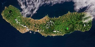
São Miguel Island, nicknamed "The Green Island", is the largest and most populous island in the Portuguese archipelago of the Azores. The island covers 760 km2 (290 sq mi) and has around 140,000 inhabitants, with 45,000 people residing in Ponta Delgada, the archipelago's largest city.

Faial Island, also known in English as Fayal, is a Portuguese island of the Central Group of the Azores.

São Roque do Pico is a municipality in the Portuguese archipelago of the Azores, occupying most of the northern side of the island of Pico. As of 2021, it has 3,221 inhabitants spread through five freguesias in an area of 142.36 km².

Prainha is a civil parish in the municipality of São Roque do Pico on the island of Pico, in the Portuguese archipelago of the Azores. It has 530 inhabitants in an area of 26.10 km².

Lagoa is a municipality in the southwestern part of São Miguel Island in the Azores. The population in 2011 was 14,442, in an area of 45.59 km². Lagoa is located east of Ponta Delgada, the island capital.

Lagoa do Fogo is a crater lake within the Água de Pau Massif stratovolcano in the center of the island of São Miguel in the Portuguese archipelago of the Azores. The highest lake located on the island of São Miguel, the region is protected by governmental regulation that does not permit any constructions around the lake.

Mount Pico is a currently quiescent stratovolcano located on Pico Island, in the mid-Atlantic archipelago of the Azores. It is the highest mountain in Portugal, at 2,351 metres (7,713 ft) above sea level, and is one of the highest Atlantic mountains; it is more than twice the elevation of any other peak in the Azores. It has been a designated nature reserve since 1972.

Ponta dos Rosais is a promontory located along the northwestern coast of the parish of Rosais, municipality of Velas, on the island of São Jorge in the Portuguese archipelago of the Azores.
Pico da Vara is the highest mountain on the island of São Miguel, in the Portuguese archipelago of the Azores, and principal special protection of the Nature Reserve of Pico da Vara. The area around the mountain includes the largest remaining stand of the native laurisilva forest on the island, home to the critically endangered endemic Azores bullfinch.

The Lagoa do Negro is an ephemeral lake and humid zone located in the civil parish of Biscoitos, municipality of Praia da Vitória, on the island of Terceira, Portuguese archipelago of the Azores.

The Nature Park of Faial, or simply Faial Nature Park (PNF), developed from the intention of better managing the protected areas of the island of Faial, and was instituted by the Secretaria Regional do Ambiente e do Mar of the Autonomous Regional Government of the Azores.

Pseudanchomenus is a beetle genus in the family of ground beetles (Carabidae). Its only described species, Pseudanchomenus aptinoides, is endemic to the Azores archipelago.

The Azores Geopark is a network of 121 geographically-dispersed sites of geographic heritage and marine areas that covers the nine volcanic islands of the archipelago of the Azores. This network is managed by the Azores Geopark Association, a non-profit association, with its headquarters in Horta on the island of Faial, established 19 May 2010. It is part of the European Geoparks Network and the UNESCO Global Geoparks Network. The Association's mission is to ensure the geological conservation, environmental education and sustainable development, while promoting the well-being of the population and a respect for the environment.
The Achada Plateau is an extensive volcanic mountain range located on Pico Island, Azores. It is a protected area with many valuable features that characterize the Azorean landscape. It is included in two Natura 2000 sites, one of which is classified as an Important Bird Area. Part of the plateau also includes a ramsar wetland. It is one of the three main geomorphological units that comprise Pico Island.

Topo Volcano is an inactive shield volcano located on Pico Island, Azores. The volcano measures 1,002 m (3,287 ft) in height and occupies the southernmost area of the island. It is part of the Lajes Volcanic Complex, the oldest volcanic apparatus which gave origin to the island, around 300,000 years ago. The volcano was created by a 600 m (2,000 ft) thick superposition of alternated Pāhoehoe lava flows and thin layers (10%) of pyroclastic material.

Trechus terrabravensis is a beetle species in the family Carabidae endemic to Terceira Island, Azores, Portugal.

