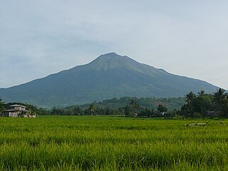
Oriental Mindoro is a province in the Philippines located on the island of Mindoro under Mimaropa region in Luzon, about 140 kilometres (87 mi) southwest of Manila. The province is bordered by the Verde Island Passage and the rest of Batangas to the north, by Marinduque, Maestre de Campo Island, Tablas Strait and the rest of Romblon to the east, by Semirara and the rest of Caluya Islands, Antique to the south, and by Occidental Mindoro to the west. Calapan, the only city in the island, is the provincial capital.

Iloilo is a province in the Philippines located in the Western Visayas region. Its capital is the city of Iloilo. Iloilo occupies a major southeast portion of the Visayan island of Panay and is bordered by the province of Antique to the west, Capiz to the north, the Jintotolo Channel to the northeast, the Guimaras Strait to the east, and the Iloilo Strait and Panay Gulf to the southwest.

Negros Occidental is a province in the Philippines located in the Western Visayas region. Its capital is the city of Bacolod. It occupies the northwestern half of the large island of Negros, and borders Negros Oriental, which comprises the southeastern half. Known as the "Sugarbowl of the Philippines", Negros Occidental produces more than half the nation's sugar output.

Bacolod, officially the City of Bacolod, or often referred to as Bacolod City, is a 1st class highly urbanized city on Negros Island in Western Visayas (Region VI), Philippines. It is the capital of the province of Negros Occidental where it is geographically situated but governed administratively independent from it.
El Nido, officially the Municipality of El Nido, is a 1st class municipality in the province of Palawan, Philippines. According to the 2015 census, it has a population of 41,606 people.

Tablas is the largest of the islands that comprise the province of Romblon in the Philippines. The name of the island was of Spanish origin. Before the colonization of the Philippines, Tablas was known as the Island of Osigan. At the time of contact with Westerners, Osigan had a population of two hundred and fifty people living in small villages. Wax was produced in this island.

Dauin, officially the Municipality of Dauin is a 4th class municipality in the province of Negros Oriental, Philippines. According to the 2015 census, it has a population of 27,786 people.

Cadiz, officially the City of Cadiz, is a 2nd class city in the province of Negros Occidental, Philippines. It was the capital of the short-lived Province of Negros del Norte, before the creation of the province was declared unconstitutional on August 18, 1986.

Cauayan, officially the Municipality of Cauayan, is a 1st class municipality and the largest settlement in the province of Negros Occidental, Philippines. According to the 2015 census, it has a population of 102,165 people.

Lavezares, officially the Municipality of Lavezares, is a 4th class municipality in the province of Northern Samar, Philippines. According to the 2015 census, it has a population of 28,770 people.

San Antonio, officially the Municipality of San Antonio, is a 5th class municipality in the province of Northern Samar, Philippines. According to the 2015 census, it has a population of 9,058 people.

Carles, officially the Municipality of Carles, is a 2nd class municipality in the province of Iloilo, Philippines. According to the 2015 census, it has a population of 68,160 people.

Parang is a 1st class municipality in the province of Maguindanao, Philippines. According to the 2015 census, it has a population of 89,194 people.

Apo Island is a volcanic island covering 74 hectares in land area, 7 kilometers off the southeastern tip of Negros Island and 30 kilometers south of the Negros Oriental capital of Dumaguete in the Philippines. The name "Apo" means "elder" or "respected ancestor" in the Visayan languages.

Cayo Largo del Sur, or simply Cayo Largo, is a small resort island in Cuba, off the south coast of the northwestern part of the main island in the Caribbean Sea. The cay is about 25 kilometers (16 mi) long and 3 kilometers (1.9 mi) wide and is the second largest island in the Canarreos Archipelago. Cayo Largo is part of the special municipality of Isla de la Juventud.
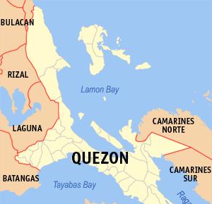
Lamon Bay is a large bay in the southern part of Luzon island in the Philippines. It is a body of water connecting the southern part of Quezon province to the Philippine Sea, a marginal sea of the Pacific Ocean. It borders on the coastal towns of Atimonan, Gumaca, Plaridel, Lopez, Calauag, and the islands of Alabat.
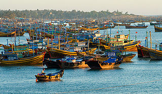
Mũi Né is a coastal fishing town in the south-central Bình Thuan Province of Vietnam. The town, with approximately 25,000 residents, is a ward of the city of Phan Thiết. Mui Ne and the other wards of Phan Thiet stretch along the coast for approximately 50 kilometers and have been transformed into a resort destination since the mid 1990s, when many visited the area to view the solar eclipse of October 24, 1995. Most notably, tourism has developed in the area from the Phan Thiet city center to Mui Ne, which has more than a hundred beach resorts, as well as restaurants, bars, shops and cafes.
Negros is the fourth largest island of the Philippines, with a land area of 13,309.60 km2 (5,138.87 sq mi). Negros is one of the many islands that comprise the Visayas, in the central part of the country. The predominant inhabitants of the island region are mainly called Negrenses. As of 2015, the total population of Negros is 4,414,131.
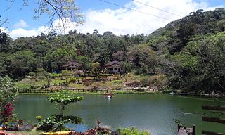
Mambukal Resort, officially the Township of Mambukal or simply known as Mambukal, is a resort township located within the boundaries of the municipality of Murcia, Negros Occidental. As a township, it is directly governed by the Provincial Government of Negros Occidental, which also manages Mambukal Mountain Resort in the 6-hectare townsite near Brgy. Minoyan. The resort is owned and managed by the Provincial Government of Negros Occidental under its Economic Enterprise Development Department.

Sion-sur-l'Océan is a village and seaside resort in the Vendée department in western France. Sion is on the coast of the Atlantic Ocean in front of the island of Yeu. Sion-sur-l'Océan is part of the commune of Saint-Hilaire-de-Riez.