
The Burdekin River is a river in North and Far North Queensland, Australia. The river rises on the northern slopes of Boulder Mountain at Valley of Lagoons, part of the western slope of the Seaview Range, and flows into the Coral Sea at Upstart Bay over 200 kilometres (124 mi) to the southeast of the source, with a catchment area of approximately 130,000 square kilometres (50,000 sq mi). The Burdekin River is Australia's largest river by (peak) discharge volume.
Lake Barlee is an intermittent salt lake. With a surface area of 1,980 square kilometres (764 sq mi), it is the second largest lake in Western Australia.

Glenrock Lagoon, an intermediate fresh water small coastal creek, is located within the Lake Macquarie local government area in the Newcastle and Hunter regions of New South Wales, Australia. The lake is located near the Newcastle suburbs of Adamstown and Dudley and is situated about 153 kilometres (95 mi) north of Sydney.
Lake Gregory, or Paraku in the Walmajarri language, is a permanent brackish lake located in the Kimberley region of Western Australia, situated between the Great Sandy Desert and the Tanami Desert. Following monsoonal rains it may hold fresh water, but becomes more saline after a number of dry years.

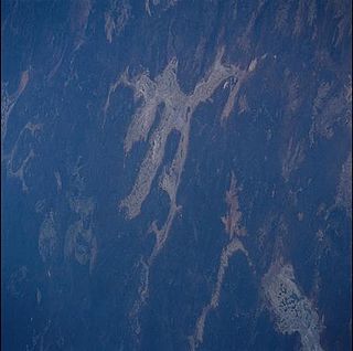
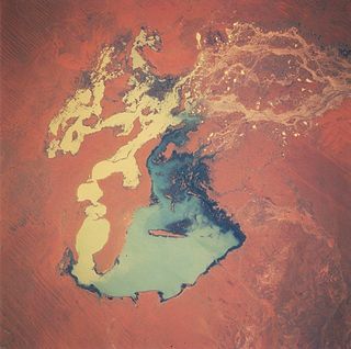
Lake Frome / Munda is a large endorheic lake in the Australian state of South Australia to the east of the Northern Flinders Ranges. It is a large, shallow, unvegetated salt pan, 100 kilometres (62 mi) long and 40 kilometres (25 mi) wide, lying mostly below sea level and having a total surface area of 259,615 hectares. It only rarely fills with brackish water flowing down usually dry creeks in the Northern Flinders Ranges from the west, or exceptional flows down the Strzelecki Creek from the north.

The Fortescue River is an ephemeral river in the Pilbara region of Western Australia. It is the third longest river in the state.

Wallis Lake, an open and trained wave dominated barrier estuary, is located within the Mid-Coast Council local government area in the Mid North Coast region of New South Wales, Australia. Wallis Lake is located adjacent to the towns of Forster and Tuncurry, and adjacent to the east coast, about 308 kilometres (191 mi) north of Sydney.
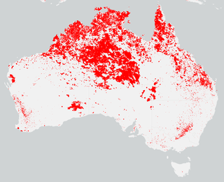
Bushfires were mostly active between September 2011 to March 2012 and caused most damage in the state of Western Australia, particularly in the South West. The state had been prepared and had expected an increased risk of bushfire following heavy spring rains as a result of a La Nina weather pattern.
Victoria River Downs Station, also known as Victoria Downs and in the past sometimes referred to as The Big Run, is a pastoral lease that operates as a cattle station in the Northern Territory of Australia, established in 1883.

Glengyle Station is a pastoral lease that operates as a cattle station in central west Queensland.
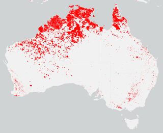
The bushfire season in the summer of 2014–15, was expected to have the potential for many fires in eastern Australia after lower than expected rainfall was received in many areas. Authorities released warnings in the early spring that the season could be particularly bad.
Boologooroo Station, commonly referred to as Boologooroo, is a pastoral lease that operates as a sheep station in Western Australia.
Mount Vernon Station is a pastoral lease that operates as a cattle station.
Turee Creek Station, often referred to as Turee Creek and also known as Turee Station, is a pastoral lease that operates as a cattle station.
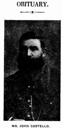
John Costello was a pioneer and pastoralist in outback Queensland.

Andamooka Station is a pastoral lease that once operated as a sheep station but now operates as a cattle station in outback South Australia.

Stuart Creek Station is a pastoral lease that once operated as a sheep station. It now operates as a cattle station in outback South Australia.

Myrtle Springs Station is a pastoral lease that operates as a sheep station in outback South Australia.
The Moyle River is a river in the Northern Territory, Australia.

County of Taunton is a cadastral unit located in the Australian state of South Australia on land on the east coast of Lake Torrens about 160 kilometres (99 mi) from the city of Port Augusta. It was proclaimed in 1877 and named after Lord Taunton who was the Secretary for the Colonies from 1855 to 1858. It has been partially divided in the following sub-units of hundreds – Bunyeroo, Carr, Edeowie, Nilpena, Oratunga and Parachilna.

